- Home
- :
- All Communities
- :
- Products
- :
- ArcGIS Online
- :
- ArcGIS Online Questions
- :
- Re: default shape area different than calculated a...
- Subscribe to RSS Feed
- Mark Topic as New
- Mark Topic as Read
- Float this Topic for Current User
- Bookmark
- Subscribe
- Mute
- Printer Friendly Page
default shape area different than calculated area
- Mark as New
- Bookmark
- Subscribe
- Mute
- Subscribe to RSS Feed
- Permalink
If I draw a polygon in an ArcGIS Online web map or in ArcPro using an AGOL layer, the default "shape__area" field is off by about a factor of 5. I need to calculate the area (in acres) of field boundaries using the default "shape__area", but dividing by 43560 (sq. ft./ac) does not work. Please see the image below where you can see the default shape__area, manually entered Acres, and measured Area in ArcPro. For some reason, the conversion from shape__area to (manually entered) acres is consistently around 8500. 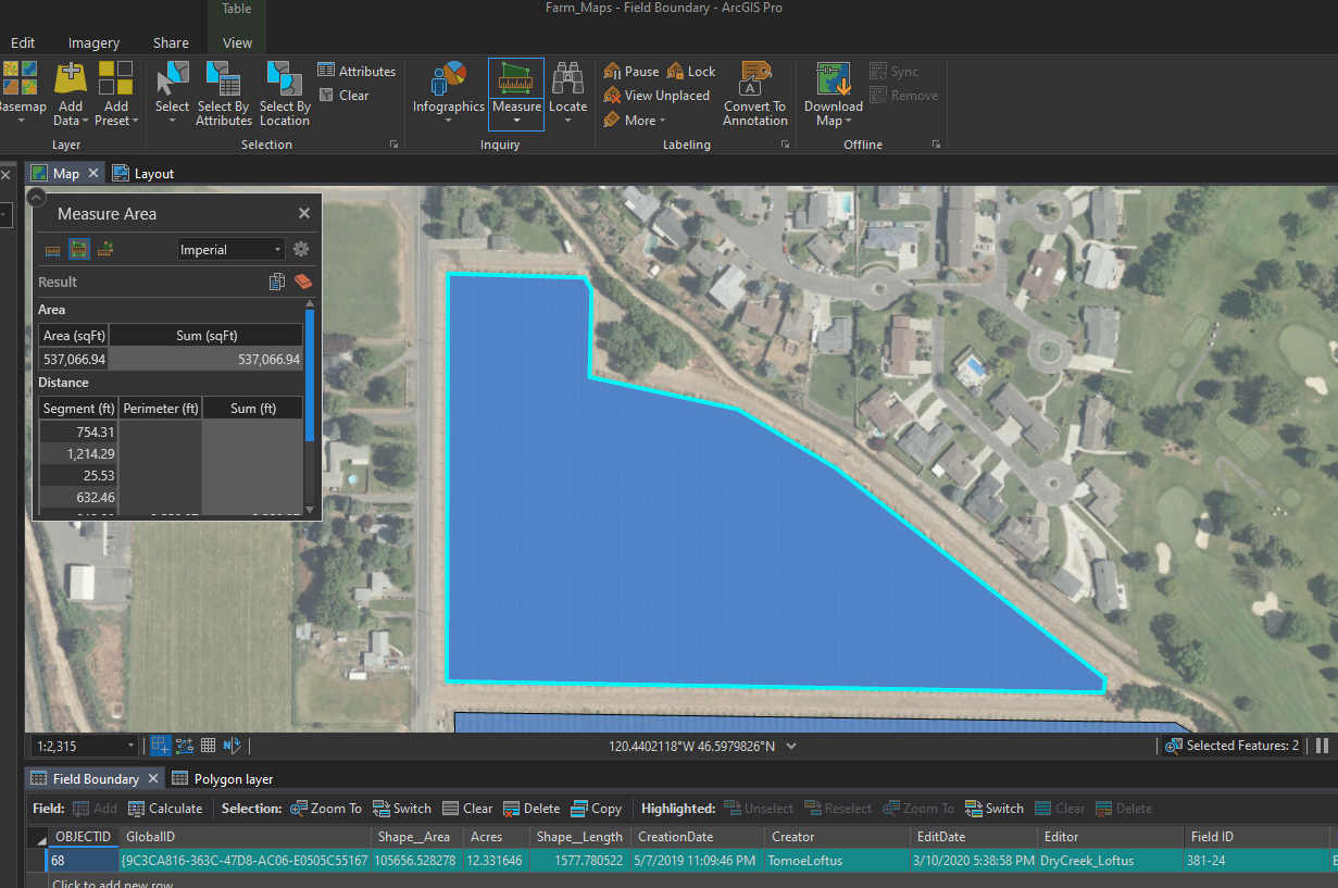
Solved! Go to Solution.
Accepted Solutions
- Mark as New
- Bookmark
- Subscribe
- Mute
- Subscribe to RSS Feed
- Permalink
For anyone else that finds themselves with this problem, the answer did lie in the projection. If I create a polygon feature layer in AGOL, it will have the WGS 84 coordinate system and give wonky area calculations. To solve this, I opened the feature layer in ArcPro, assigned a State Plane coordinate system, and calculated the area in ArcPro in the layer's attribute table. To check my work, I opened the feature layer in AGOL and used the "draw area" tool in a web map to verify the measured area matches the calculated area, and it did. I also created another data column and calculated the areas in AGOL, again to verify the areas are the same.
- Mark as New
- Bookmark
- Subscribe
- Mute
- Subscribe to RSS Feed
- Permalink
Also - Im assuming this has something to do with coordinate systems since AGOL layers are in WGS 84 and my projection is Wa State Plane South.
- Mark as New
- Bookmark
- Subscribe
- Mute
- Subscribe to RSS Feed
- Permalink
For anyone else that finds themselves with this problem, the answer did lie in the projection. If I create a polygon feature layer in AGOL, it will have the WGS 84 coordinate system and give wonky area calculations. To solve this, I opened the feature layer in ArcPro, assigned a State Plane coordinate system, and calculated the area in ArcPro in the layer's attribute table. To check my work, I opened the feature layer in AGOL and used the "draw area" tool in a web map to verify the measured area matches the calculated area, and it did. I also created another data column and calculated the areas in AGOL, again to verify the areas are the same.