- Home
- :
- All Communities
- :
- Products
- :
- ArcGIS Online
- :
- ArcGIS Online Questions
- :
- Attachment issues
- Subscribe to RSS Feed
- Mark Topic as New
- Mark Topic as Read
- Float this Topic for Current User
- Bookmark
- Subscribe
- Mute
- Printer Friendly Page
Attachment issues
- Mark as New
- Bookmark
- Subscribe
- Mute
- Subscribe to RSS Feed
- Permalink
I have a feature dataset that I has attachments enabled, and when I enabled them there were two additional files created, one with "__ATTACH" and one with "__ATTACHREL" on the end of the file name as a table and relationship class. I have the dataset published so our staff can attach them via AGOL, but I cannot access the images from my desktop ArcMap. I am fairly certain that I'm missing some step somewhere, but I can't believe that this should be the case. I need to be able to use the attachments, and right now they are pointless.
I have tried working with a copy of the data, thinking maybe I set up the attributes wrong but when I try to use the attachment toolset in Toolbox, it doesn't like the tables that are automatically generated for use in a match table. So why generate a match table when there is already a table and relationship class that is automatically set up?
- Mark as New
- Bookmark
- Subscribe
- Mute
- Subscribe to RSS Feed
- Permalink
Hi Saskia,
When you publish the data, are you creating an ArcGIS Online hosted feature service, or an ArcGIS Server service?
Would you be able to copy the data to a File Geodatabase, zip it and attach to this thread?
- Mark as New
- Bookmark
- Subscribe
- Mute
- Subscribe to RSS Feed
- Permalink
ArcGIS Server service, and I would be happy to get you the file. I put the file in here, but the tables that automatically are generated are not generated in the geodatabase with the features. I will be happy to include those 2 tables if you would like.
- Mark as New
- Bookmark
- Subscribe
- Mute
- Subscribe to RSS Feed
- Permalink
That is strange. When you enable attachments, the attachment table will automatically be created in the geodatabase. Can you attach the tables as well?
- Mark as New
- Bookmark
- Subscribe
- Mute
- Subscribe to RSS Feed
- Permalink


In the first screen shot, you can see the contents of the geodatabase for the projects in the right panel, in the lower screen shot you can see in the left panel where the CIP_ATTACH and CIP_ATTACHREL tabels are placed. I'll copy you the two tables if you would like them.
- Mark as New
- Bookmark
- Subscribe
- Mute
- Subscribe to RSS Feed
- Permalink
Hola Saskia,
In looking at the information provided and screenshots, which really helps. Usually when enabling for attachments on the feature class that is within a feature dataset. The tables that are created, will reside outside the feature dataset and not within the feature dataset as the feature class resides. In looking at the fgdb you provided, there was only one feature class (CIP). I went ahead and created a feature dataset and brought in your feature class. I then looked to enable the feature class for attachments, and you will see how the two tables created will sit outside the feature dataset and not inside with the feature classes. You will now be able to publish the feature class as either a map service or feature service or both, and then use them within the webmap in AGOL. I hope this assist you, if you have any other questions, please let us know. I am also uploading the fgdb with these changes to it, as a zip file.
Gracias, Saskia!
- Mark as New
- Bookmark
- Subscribe
- Mute
- Subscribe to RSS Feed
- Permalink
Thanks, Juan. When I originally enabled the attachments, the tables were outside the feature dataset. The problem is when I try to use them in ArcMap in order to run reports. Any ideas on that?? They are working fine in the AGOL map, which is great, but I can't access them from desktop software.
- Mark as New
- Bookmark
- Subscribe
- Mute
- Subscribe to RSS Feed
- Permalink
Hola Saskia,
If you are looking to use the canned reporting from within ArcMap, I don’t see where you would be able to use the attachments to generate a report of them. The Report Wizard as you can see in the screenshot, looks for a field that it will generate the report from that identified field. The attached images are embedded within the geodatabase, and I don’t see where the Report Wizard will be able to access them. You may want to log a support case with our Desktop Team for verification on this but in going back to my desktop days. I don’t see where this would be an out of the box option for you. Gracias, Saskia! 
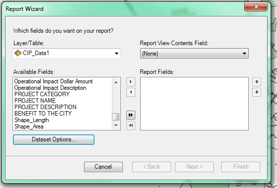
Juan
- Mark as New
- Bookmark
- Subscribe
- Mute
- Subscribe to RSS Feed
- Permalink
That is what I have run into. How can you access them to view them in ArcMap? I can't seem to even be able to view the ones that city staff has uploaded, which will cause me to rethink more than just our reporting. I really appreciate your help with this. I will certainly put in a ticket with your desktop support to get the full scoop, but feel like I'm missing something that should be simple and just can't see my way through the forest.
- Mark as New
- Bookmark
- Subscribe
- Mute
- Subscribe to RSS Feed
- Permalink
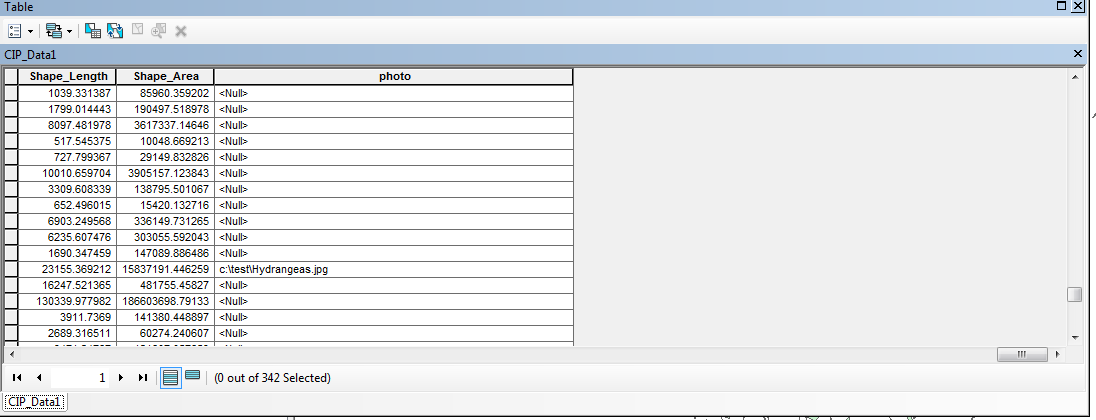
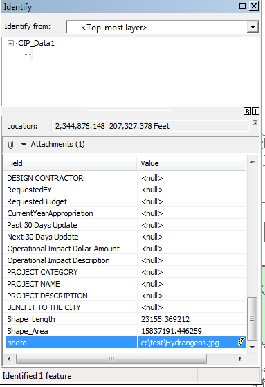
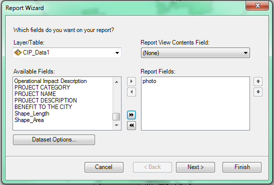
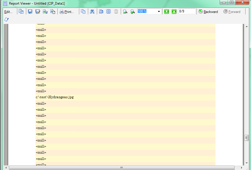
Hola Saskia,
Ok, so this is a bit old school and yes I can be old school. Prior to using attachments, you were able to create a field (eg. photo) and enter the path directory of where your attachments would reside, local or on the server. As you can see in my screen shots, you are then able to generate a report for that field, again it is a bit old school workflow but it may give you what you are looking to do. Just keep in mind this is more manual work by creating a new field on your data, where using the Enabled for attachments can will easier. I hope this give you another option to use from within ArcMap, and this will allow you to run reports. Gracias, Saskia!
Using Hyperlinks
http://desktop.arcgis.com/en/desktop/latest/map/working-with-layers/using-hyperlinks.htm
Juan