- Home
- :
- All Communities
- :
- Products
- :
- ArcGIS Online
- :
- ArcGIS Online Questions
- :
- Arcade Expression for Geometry in ArcGIS Online Po...
- Subscribe to RSS Feed
- Mark Topic as New
- Mark Topic as Read
- Float this Topic for Current User
- Bookmark
- Subscribe
- Mute
- Printer Friendly Page
Arcade Expression for Geometry in ArcGIS Online Popup
- Mark as New
- Bookmark
- Subscribe
- Mute
- Subscribe to RSS Feed
- Permalink
Hi. In ArcGIS Online using the web map Attribute Expressions builder, I'm trying to pull feature xy coordinates to show in a popup. In the builder, my code successfully tests with a value; but the value in the popup and layer table is empty. I'm using a map service if that matters.
So, is this code supposed to work? Or am I doing something wrong?
Thanks.
- Mark as New
- Bookmark
- Subscribe
- Mute
- Subscribe to RSS Feed
- Permalink
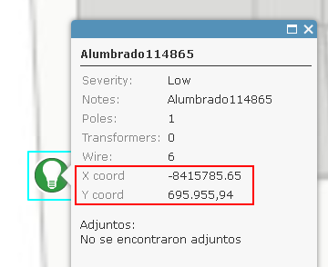
Not sure what might be going wrong in your case. I just configured something similar and it works.

I entered the pop-up settings and added two expressions:

and the result is displayed:
- Mark as New
- Bookmark
- Subscribe
- Mute
- Subscribe to RSS Feed
- Permalink
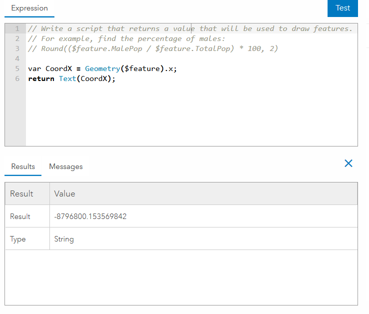
This function seems to work properly.
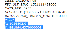
Text(Geometry($feature).x);
and returns this in the popup

Have you checked the popup configuration to see if it's displaying the custom expression?
- Mark as New
- Bookmark
- Subscribe
- Mute
- Subscribe to RSS Feed
- Permalink
Thanks for the help so far. Are you using map services or feature layers/services?
Thanks.
- Mark as New
- Bookmark
- Subscribe
- Mute
- Subscribe to RSS Feed
- Permalink
I used a hosted feature service.
- Mark as New
- Bookmark
- Subscribe
- Mute
- Subscribe to RSS Feed
- Permalink
Thanks everyone for the help so far. I do see the code works with map services. The field in the table won't always populate (for me anyway) so I didn't catch that it worked in the popup.
I think the problem is with the map service I started with. I haven't figure out why, yet, but it appears that the "point" feature-type layer loaded via the map service is really a "multipoint" layer/feature class. For some reason the point-related arcade expression code works with the layer in the expression builder, but perhaps not outside of the builder. I'm looking more closely at our map service and the map viewer.
If anyone would like to take a closer look, here's the map service: NCDOT_STIP (MapServer)
Thanks again. I really appreciate the help.
- Mark as New
- Bookmark
- Subscribe
- Mute
- Subscribe to RSS Feed
- Permalink
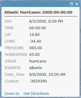
For multipoint geometry you may want to try this:
return Round(Geometry($feature).points[0].X, 2)and:
return Round(Geometry($feature).points[0].Y, 2)... since it is a collection of points although each multipoint only has a single point (as far as I could see from a query on your REST service)
- Mark as New
- Bookmark
- Subscribe
- Mute
- Subscribe to RSS Feed
- Permalink
How can i get de X and Y point from my feature in the coordenate system from the rest url?
I need to create a custom expression to put it on the popup window with this info.
the Geoametry function retorns only in web mercator.
- Mark as New
- Bookmark
- Subscribe
- Mute
- Subscribe to RSS Feed
- Permalink
In case you need the coordinates in WGS 1984, I have a couple of posts that show an example of how you can convert Web Mercator coords to WGS 1984. This might be useful in case you need to create a hyperlink to Streetview or Waze or send the coordinates to prefill a Survey123 form.
Examples (in Spanish) can be found here: