- Home
- :
- All Communities
- :
- Products
- :
- ArcGIS Online
- :
- ArcGIS Online Questions
- :
- Alignment issues: Desktop -> ArcGIS Online -> Coll...
- Subscribe to RSS Feed
- Mark Topic as New
- Mark Topic as Read
- Float this Topic for Current User
- Bookmark
- Subscribe
- Mute
- Printer Friendly Page
Alignment issues: Desktop -> ArcGIS Online -> Collector
- Mark as New
- Bookmark
- Subscribe
- Mute
- Subscribe to RSS Feed
- Permalink
Hello, I'm preparing to use ArcGIS collector to gather field data in Cambodia. This involves creating a file geodatabase in ArcMap, preparing it for upload to ArcGIS Online, creating a webmap, accessing the webmap on collector, and then collecting information.
I'm having a problem getting the base layer from ArcGIS online to align with the data I have prepared in ArcMap 10.6. I am using a number of layers from previous work -- including national borders, populated locations, roads, rivers, etc. Much of that information is native Indian_1960_48N but I made sure that the dataframe on the .mxd is WGS_1984 so when it is added I believe that ArcMap should project it on the fly to WGS_1984.
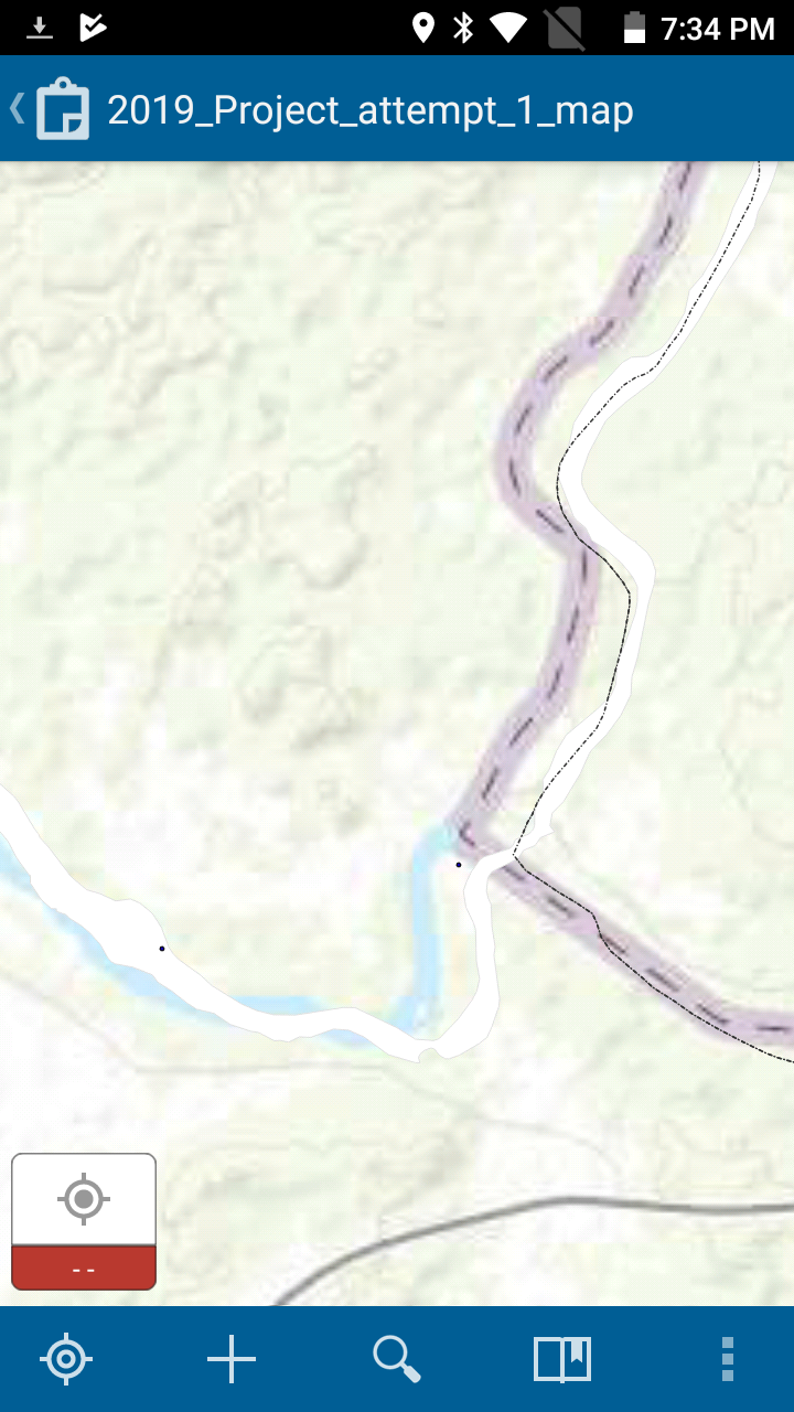
However, once I have publish this as a service to ArcGIS online, and add a basemap to it (World Topographic for example), my data is skewed by about 25 - 100 meters from the basemap, even though my data all lines up with itself. The same is true if import the ESRI basemap into my ArcGIS project (i.e. in ArcMap) -- the rivers, borders, etc. are all somewhat off.
The inserted image shows the ESRI world topo basemap, with blue river and thick blue border line, and my information (white river, thin dotted border line)
I'm concerned that when I collect information in the field, it will align with the basemap and when I sync it or import it to my GDB it will be out of sync with the layers there.
It seems strange that there would be that much difference between the wgs 1984 web mercator and the WGS 84 UTM 48N that my map is in, no?
What can I do? Is there someway to "project" all my layers to the correct WGS_84? Thanks.
- Mark as New
- Bookmark
- Subscribe
- Mute
- Subscribe to RSS Feed
- Permalink
This seems to be a geo-datum transformation issue and it looks like the default transformation between these two projections does not work well. Would you be able to set the datum transformation from ArcMap between the source data projection and the map/data frame projection when authoring the sd file. We will honor the datum transformation if exists in sd file and it will be saved with the created feature service.
Khaled Hassen
Online Feature Service Lead