- Home
- :
- All Communities
- :
- Products
- :
- ArcGIS Online
- :
- ArcGIS Online Questions
- :
- Adding CSV file from a URL is not showing columns
- Subscribe to RSS Feed
- Mark Topic as New
- Mark Topic as Read
- Float this Topic for Current User
- Bookmark
- Subscribe
- Mute
- Printer Friendly Page
Adding CSV file from a URL is not showing columns
- Mark as New
- Bookmark
- Subscribe
- Mute
- Subscribe to RSS Feed
- Permalink
In ArcGIS Online, when adding a csv file from a URL (Add Layer from Web), the system doesn't recognize the columns, it only shows _html_. But my csv file contains the following columns: FID, ISO-3166 alpha-2, NS deployed
- Mark as New
- Bookmark
- Subscribe
- Mute
- Subscribe to RSS Feed
- Permalink
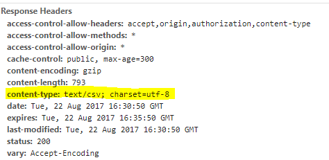
Hi Sébastien - one thing to check is the response from the server providing the csv. The headers that are returned when the request is made from the map viewer may be causing the CSV to be interpreted as something other than text (which would potentially cause parsing to fail, etc).
You can check this out using a browser's developer tools (Chrome has a great set). Esri technical support can assist as well. In the response headers from the request for the CSV, you should see content-type as a property. This is an example from the USGS for their recent earthquakes feed:
- « Previous
-
- 1
- 2
- Next »
- « Previous
-
- 1
- 2
- Next »