- Home
- :
- All Communities
- :
- Products
- :
- ArcGIS Online
- :
- ArcGIS Online Ideas
- :
- Range Slider for non-time-enabled data in ArcGIS O...
- Subscribe to RSS Feed
- Mark as New
- Mark as Read
- Bookmark
- Follow this Idea
- Printer Friendly Page
Range Slider for non-time-enabled data in ArcGIS Online
- Mark as New
- Bookmark
- Subscribe
- Mute
- Subscribe to RSS Feed
- Permalink
Hello everybody,
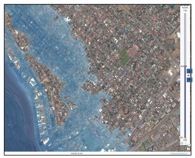
I just came across the range slider option in ArcGIS Pro (Get started with the range slider—ArcGIS Pro | ArcGIS for Desktop) which works fabulously for developing Climate Change related coastal flood scenarios (see picture).
The Range Slider very easily enables us to produce flood maps which are available for other parts of the world already - but which were produced with complicated Java Scripting (e.g. NOAA's Sea Level Rise Viewer, and the Australian CoastalRisk Viewer) However, when I tried to push my ArcGIS Pro Range Slider maps online, I found that the Range Slider is not at all available in ArcGIS Online! 😞
I tried a work around using the Time Slider, but the results are not very satisfactory, as I had to persuade AGOL that my flood levels are actually years. Converting a flood level of 4.5m into a year 4500 looked quite clumsy in the output...
Therefore, PLEASE could you implement the Range Slider into AGOL as well?
It would make our Climate Change adaptation work in Africa SO much easier.
Many thanks in advance!
- « Previous
-
- 1
- 2
- Next »
This is a great idea! Most of the time web map users are trying to filter some sort of data. And what could be better for such task than using an interactive slider?
I want this so much. It would be such a simple, fantastic way for my end users to filter data. I was so bummed when I saw such a slider was available in Pro, but not Online.
This could also be used for some many purposes. A big one I could use would be to quickly switch between building floors and their associated data. (i.e. 1st Floor Floor plan with 1st Floor Fire Extinguishers and then switching to 2nd Floor Plan and 2nd Floor Fire Extinguishers). Implementing this in ArcGIS Online in a simple way for users is impossible right now.
Here is a link to a similar proposal which other users may be interested in voting up: https://community.esri.com/ideas/14469-advanced-time-slider-widget-for-dashboard-theme
Count me in too.
Please allow AGOL the time functions and options that arcgis Pro has. The time function is a very powerful tool for GIS project buy-in by administrators, supervisors, and the public. Currently the online version of the time slider is severely limiting! Specifically, I would love to see AGOL enable the ArcPro time option that allows the slider to focus only available data instead of equal time frames or time ranges. Thanks!
Agreed with all above. The online version of the time slider and slider instant app should be more configurable.
It would be really nice to have this range slider in AGOL if it's able to show BCE times! Right now, ArcGIS Online is not compatible with BCE Dates - we have to do some interesting spreadsheet workaround if we want to show any dates that are pre-1 CE.
FWIW, while not available in the Map Viewer in ArcGIS Online, one can now use the Slider Instant App in ArcGIS Online to obtain a similar experience as the Range Slider in Pro. It supports a slider experience that can utilize data from either time-enabled or numeric fields.
You must be a registered user to add a comment. If you've already registered, sign in. Otherwise, register and sign in.