- Home
- :
- All Communities
- :
- Products
- :
- ArcGIS Online
- :
- ArcGIS Online Ideas
- :
- Making the Selected Item Symbology for Colour Blin...
- Subscribe to RSS Feed
- Mark as New
- Mark as Read
- Bookmark
- Follow this Idea
- Printer Friendly Page
- Report Inappropriate Content
Making the Selected Item Symbology for Colour Blindness
- Mark as New
- Bookmark
- Subscribe
- Mute
- Subscribe to RSS Feed
- Permalink
- Report Inappropriate Content
I work at a council and we require to put a web map app. onto our website showing parish boundaries. The problem I have is that when you select an area it turns the outline cyan (I know, a standard thing for ArcGIS) however this makes it invisible for colour-blind people. As we are a council we must conform to certain accessibility standards for anything we put onto our public facing map. For this reason I would like a functionality to amend the 'highlighted' item symbology so that it can be seen by those who are colour blind.
- Mark as Read
- Mark as New
- Bookmark
- Permalink
- Report Inappropriate Content
Hi Abi Tassie, the ColorBrewer 2.0 website includes an option to only show colourblind safe colour schemes.
In addition, from ESRI's ArcGIS Blog post titled 'Brewing a new color palette for ArcGIS Pro':
...we worked with our friend and colleague Cynthia Brewer to implement her ColorBrewer color schemes as part of ArcGIS Pro.
...With such high quality research already done, it made sense to incorporate it into ArcGIS Pro rather than users having to go outside the software to find colors they wanted to work with. With Cindy’s agreement, we baked the ColorBrewer specifications into ArcGIS Pro to give map-makers access to these great color schemes as a default. Now, picking great color schemes has never been so easy. Of course, the ColorBrewer schemes which support colorblind safe palettes are also included.
Hope this helps.
- Mark as Read
- Mark as New
- Bookmark
- Permalink
- Report Inappropriate Content
Hi Richard,
Sorry, perhaps I didn't explain very well. It's not symbology I need changed but rather the default colour it changes when you select something like below:
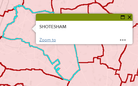
Thanks,
Abi
You must be a registered user to add a comment. If you've already registered, sign in. Otherwise, register and sign in.