- Home
- :
- All Communities
- :
- Products
- :
- ArcGIS Network Analyst
- :
- ArcGIS Network Analyst Questions
- :
- Re: Use of "Location Allocation" option to determi...
- Subscribe to RSS Feed
- Mark Topic as New
- Mark Topic as Read
- Float this Topic for Current User
- Bookmark
- Subscribe
- Mute
- Printer Friendly Page
Use of "Location Allocation" option to determine locations of a Wastewater treatment plants
- Mark as New
- Bookmark
- Subscribe
- Mute
- Subscribe to RSS Feed
- Permalink
- Report Inappropriate Content
Hello all!
I have a study area of 400 km2 where there are around 180 villages spread (See picture attached). I am trying to determine the best location of a number of Wastewater treatment plants (WWTP) in a way that the distance from each village to the WWTP would be the minimum possible, assuming that the pipes will be installed right under the main roads that connect the villages between them.
I need to make the network analysis many times with the variation of number and location of the WWTP to determine the cheapest way in terms of number of WWTP and their location. The costss in this case are directly derived from the lenght of the pipes - which I assume is the same lenght of the roads under which the pipes would be installed.
I am using the Location - Allocation option in ArcGIS Pro, but I can not figure out how to set the options in order for the analysys not to consider the impedance but only the distance of the roads (because in my case the pipes and transport of wastewater will not be affected by the velocity on the roads, so I do not need to save time in that kind of transportation).
Could you please guide me? Am I using an incorrect tool? or maybe do I need to build a model to do the analysis that I require?
The main goal of my research is to define what is the best option for the villages in the study area: a wastewater treatment plant for each of the 180 villages? or how many villages I should connect to one WWTP in a way that the pipes would be as shortest ad possible, therefore reducing the costs associated with the pipes?
Thank you very much!! I really need a guidance on this matter.
Att: Sara Ramos

- Mark as New
- Bookmark
- Subscribe
- Mute
- Subscribe to RSS Feed
- Permalink
- Report Inappropriate Content
If I understand correctly, you want to find the optimal solution that minimizes the distance along the roads from the villages to the wastewater treatment plant potential sites. So, for your network analysis problem, you need to optimize distance rather than travel time.
You need to set the Travel Mode option (it's on the Location-Allocation ribbon) to use a travel mode that optimizes distance. Your post doesn't mention what network data source you're using, but if you're using ArcGIS Online or Streetmap Premium, there should be a "Driving Distance" travel mode that solves for distance instead of drive time. If you are using your own network dataset, then it's up to you to construct a travel mode on that network dataset that uses an impedance attribute that calculates distance instead of time. If you clarify what type of network you're using, I can provide further detail on that if necessary.
- Mark as New
- Bookmark
- Subscribe
- Mute
- Subscribe to RSS Feed
- Permalink
- Report Inappropriate Content
Dear Melinda,
You completely understood what I intend to do :). I made my own netwok dataset from a shapefle of the streets of the area of interest (yellow lines in the image that I attached in the previous post).
When I adjusted the properties of that Network dataset, I chose as "Type": Driving, and as "Impedance": Length (see image attached). However I am not sure if my own network database is correctly set-up.
In this case, that is all what should be done for this case? I mean, the impedance attribute should be based on length instead of time?
Thank you very much for your answer and attention.
Regards,
Sara Ramos
- Mark as New
- Bookmark
- Subscribe
- Mute
- Subscribe to RSS Feed
- Permalink
- Report Inappropriate Content
There are a few steps/levels that need to be considered, but it seems like everything is mostly set up correctly already. Below is a sort of reverse-order list of things that need to be considered. I'm starting with the part you select when doing your analysis, and it's sort of backing up all the way through the network configuration. You would have to do the steps in the reverse order, but I'm explaining it this way because I think it's easier to understand conceptually.
- When you do your analysis, make sure to select your "automobil_distance" travel mode on the ribbon. That ensures that you are using the travel mode you specifically configured for your purpose.
- You need to make sure the "automobil_distance" travel mode is configured the way you want it. A travel mode is essentially just a bucket of other settings that model a particular mode of travel. You want to use an impedance based on distance, so your Impedance property in the Costs section needs to be set to a cost attribute that models distance. In your case, it's set to a cost attribute called "Length", which shows units of meters in your screenshot, so this seems good.
- You need to make sure that the "Length" cost attribute is correctly calculating the length of the streets. To do that, switch to the Costs tab in the network dataset properties Travel Attributes page, find "Length" in the list of cost attributes, and examine its properties. My guess is that this is the automatically-generated distance attribute you always get when you create a new network dataset, so it's probably just using the shape length of the roads to calculate the length. If this is good enough for you, just leave it. Otherwise, you might want to read more about cost attributes and evaluators so you can properly configure the way it calculates distance.
- Mark as New
- Bookmark
- Subscribe
- Mute
- Subscribe to RSS Feed
- Permalink
- Report Inappropriate Content
Dear Melinda,
Thank you very much for the information. Yes, what you mentioned was considered when I made network dataset, and I am running the tool for location allocation with different configurations to analyse the results.
I might write again in the near future if a new issue arises.
Thanks a lot again!!
Sara Ramos
- Mark as New
- Bookmark
- Subscribe
- Mute
- Subscribe to RSS Feed
- Permalink
- Report Inappropriate Content
Dear Melinda,
I used ArcGIS online to run the loccation allocation analysis, using exactly the same information (about facilities and demands) that I have been using with muy own network dataset (the one that I created). However, the results in ArcGIS online are different than the ones that I get using my dataset and ArcGIS Pro.
Therefore, I am wondering why does this happen. It might be that my dataset has errors? Is there a way to kind of validate my network dataset? I created my dataset basically with the polylines that I delineated of all the roads in my study area. No more information was included.
Thank you very much again and I look forward to help on this respect.
Regards,
Sara Ramos
- Mark as New
- Bookmark
- Subscribe
- Mute
- Subscribe to RSS Feed
- Permalink
- Report Inappropriate Content
It is not unexpected to get different results with ArcGIS Online and your own network. The network dataset used by ArcGIS Online is a comprehensive dataset using the highest-quality data available from our data vendors. It includes detailed street and path geometry as well as an extensive set of attributes defining the characteristics of the streets, which are used in calculating impedances and restrictions.
Your own data may have some differences in geometry - roads in slightly different places, certain roads missing, etc. Thus, the optimal paths between places on the network may differ slightly. You might also have some connectivity errors - places where the streets seem topologically connect but aren't actually logically connected in the network.
Even if the geometry of the streets is identical, there is probably a difference in attributes between your data and the ArcGIS Online data. The impedance calculations may be different, and ArcGIS Online might be using some restrictions that you are not.
Finally, it should be noted that the ArcGIS Online data contains information about turn restrictions - specific turns that are not allowed or which incur a delay. If you use the "Driving Distance" travel mode, these turn restrictions will be used, even though, for your use case, this probably doesn't make sense. If your own network doesn't have any turn restrictions, it may allow you to build your pipes following the streets around a corner where vehicles are not allowed to turn, like an intersection where you cannot turn left. But for pipes, I presume this doesn't matter. Thus, your data may actually be more appropriate for this situation. Note that there are ways you can adjust the travel modes even when using ArcGIS Online to turn off this restriction, so the issue is not insurmountable.
As far as testing your network, it's pretty hard to interpret the results of a Location-Allocation problem. It might be better to do some Service Areas where you turn on the Lines output. This will help you look for holes in your network where things might be cut off. You can also use Route to test some specific point-to-point routes to see if the results make sense.
If you are concerned about topological connectivity in your network, you can try using this downloadable sample tool to identify topologically disconnected areas: https://www.arcgis.com/home/item.html?id=b2227f745a6c4e1c94dd57810729d2a9
- Mark as New
- Bookmark
- Subscribe
- Mute
- Subscribe to RSS Feed
- Permalink
- Report Inappropriate Content
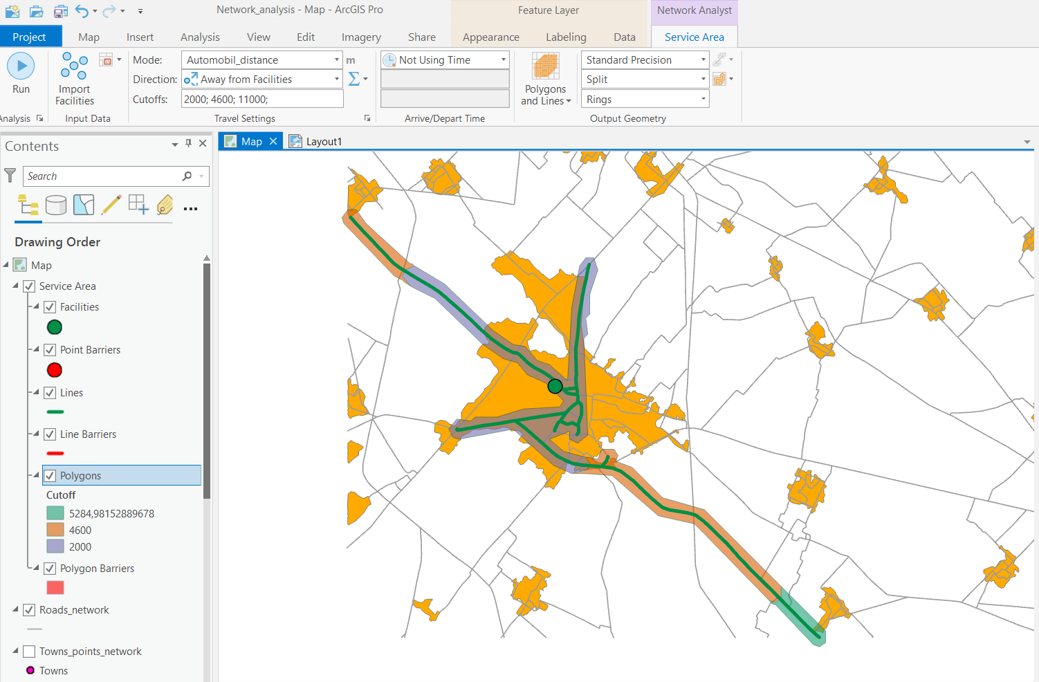
Dear Melinda,
You are right, I realised that something might be wrong with my network because when I ran the "service area" analysis the result does not include all the streets in my network, just some of them (as you can see in the image attached).
On the other hand, I downloaded the phyton package that you suggested to identify topologically disconnected areas, and read about environemnts and the instaltion of packages. However I am quite new in this topic and have not been able to find out how to install a phyton package that is not listed in the "add packages" within the "Phyton package manager" in Arcgis Pro, but that I downloaded. Could you please inform to me where I can get instructions to this instalation?
In case it is important, my ArcGIS version is Arcgis Pro 2.5.2
Again, thank you very much!
Sara Ramos
- Mark as New
- Bookmark
- Subscribe
- Mute
- Subscribe to RSS Feed
- Permalink
- Report Inappropriate Content
I don't completely understand your workflow, but basically this is what you need to do:
- In ArcGIS Pro, go to the Backstage area (hit the blue Project button), and click the Python option on the left:
- Click Manage Environments to clone your default environment.
- Once that's done and the new environment is activated, click the Add Packages button.
- Search for networkx. You should be able to click the item for networkx in the list and install it.
- After that, I think you should be good to go.

- Mark as New
- Bookmark
- Subscribe
- Mute
- Subscribe to RSS Feed
- Permalink
- Report Inappropriate Content
Dear Melinda,
I have divided my study area in 22 sub-areas and then I have run the "location allocation" tool sevetal times to create different scenarios in each sub area changing the number of Waste Water Treatment Plants as well as the cutoff, in order to compare and choose the most cost-effective option.
However this is quite time consuming, as for each configuration (number of WWTP and cutoff) I need to create a new layer for the location alocation analysis.
So, I have a question, is it a way that I can do this in a faster way? instead of repeating the creation of the location alocation layer, choosing the facilities, demands etc for each of my configurations?
Thank you very much for your attention!
Regards,
Sara Ramos