- Home
- :
- All Communities
- :
- Products
- :
- ArcGIS Network Analyst
- :
- ArcGIS Network Analyst Questions
- :
- Re: Unexpected Service Area Polygon
- Subscribe to RSS Feed
- Mark Topic as New
- Mark Topic as Read
- Float this Topic for Current User
- Bookmark
- Subscribe
- Mute
- Printer Friendly Page
Unexpected Service Area Polygon
- Mark as New
- Bookmark
- Subscribe
- Mute
- Subscribe to RSS Feed
- Permalink
Can someone please tell me how is it possible that a service area polygon is formed in this way i.e. in a place where there is no road network? I have a few such polygons formed after I ran the solver. And also all these wierd polygons don't respect my break values. I input 500m and 1000m breaks and this particular polygon for example is formed at a 0.003745m break. How does this even happen? I mean a less than 1m break? I want at least 500m and that too on the road network. The road network is located a little north of the point as you can see in the picture. Why doesn't the polygon form there?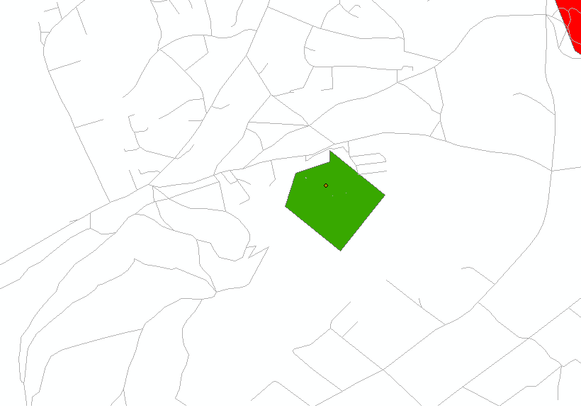
- Mark as New
- Bookmark
- Subscribe
- Mute
- Subscribe to RSS Feed
- Permalink
Or in this picture for example why isn't the 1000m polygon (red) formed for this point? I see the road network beyond the green 500m polygon (green). Then why not use it?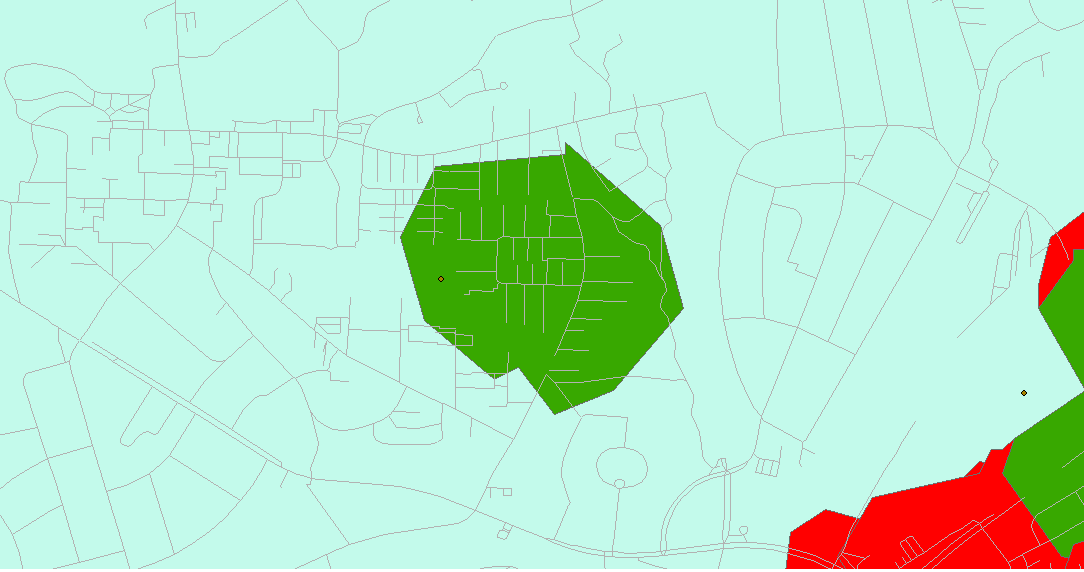
- Mark as New
- Bookmark
- Subscribe
- Mute
- Subscribe to RSS Feed
- Permalink
This definitely looks weird. It doesn't look like the service areas are lining up with the street data either. What version of ArcGIS are you using? Where is your network coming from? Are you sure you're solving on the same network that you're displaying in the map? What happens if you generate service area lines?
- Mark as New
- Bookmark
- Subscribe
- Mute
- Subscribe to RSS Feed
- Permalink
The network is the correct one for sure because here you can see the polygon is formed perfectly on the network. I didn't use the service area lines. Ill check that. And I'm using 10.3 version.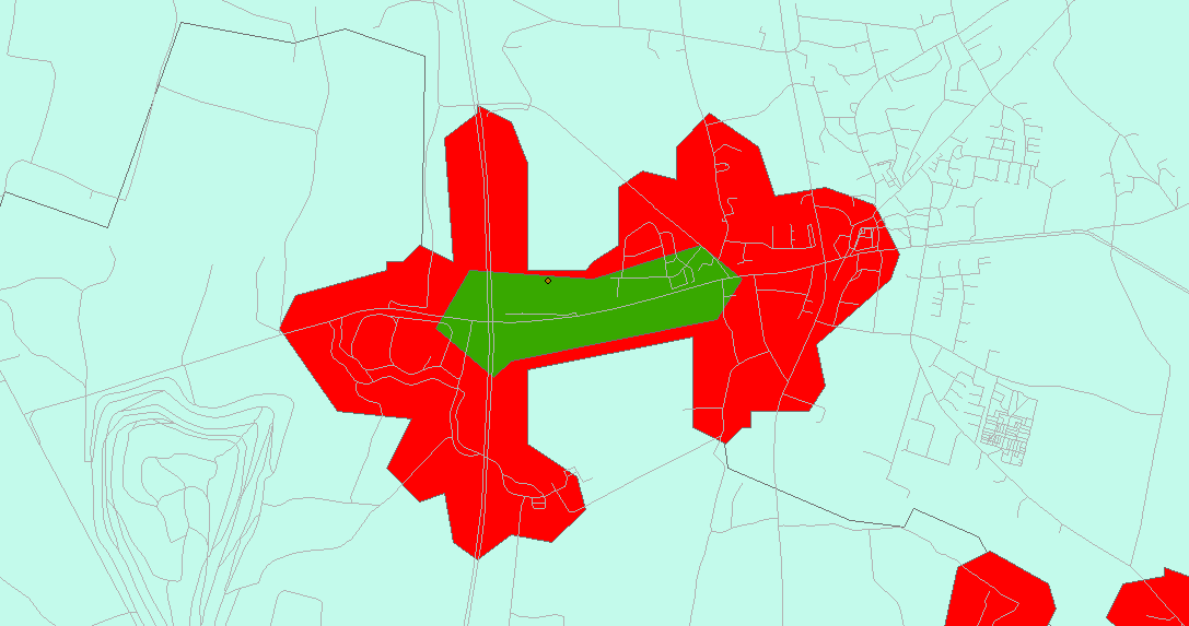
- Mark as New
- Bookmark
- Subscribe
- Mute
- Subscribe to RSS Feed
- Permalink
First image...Is the data projected or in geographic coordinates (note...not the dataframe...the actual data)
Second image...looks reasonable to me.
The green area...It would take an inordinate amount of travel to connect a larger area to the left of the point. Remember, the travel is based upon access via road ... not through free space. The polygon looks weird, because 'it' connects the dots for the distances given along a road network. Do it yourself...travel along each possible road segment and place a dot at the desired travel distance...then connect the dots as a polygon.
Area to the right with the green and red polygons...several possibilities, the point is not within the search tolerance and isn't connecting with any of the roads....or it is, but, it can only be reached by roads to the right and not by those to the left.
Throw in a one-way street or a street closure if you want to see strange service areas, closest facilities etc or change your 'impedance' to something other than distance (ie time etc).
- Mark as New
- Bookmark
- Subscribe
- Mute
- Subscribe to RSS Feed
- Permalink
Yes my data is originally also projected. But I still don't understand. It connects the dots for distances along the network, right, so why doesn't it go further not to the left but the same direction in which it formed the green 500m polygon and form the next red polygon at a distance of 1000m? Just like in the 3rd image. And also how is it possible that the break points for these polygons are something other than 500m or 1000m? You can see in the table there other break points as well. how????? I mean even if the road network doesn't form on one side, the polygons should be formed at 500 and 1000m distance in whichever direction the road network is present. Isn't it how this works?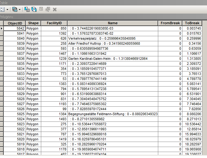
- Mark as New
- Bookmark
- Subscribe
- Mute
- Subscribe to RSS Feed
- Permalink
I am not sure why you are showing a polygon layer which has no particular service area highlighted. In your last image, I see a point at some distance from a road network ... apparently within your threshold distance, so it was found...that point is surrounded by a green polygon and a red polygon which I presume are the 500m and 1000m distance polygons (don't know what your impedance is ... distance/time/something else). It looks weird in the area of the point because there are few roads near it, it is surrounded by huge gaps in space. What NA uses to place a point that is not exactly along a network but displaced from it, would be conjecture on my part. To test the distance, move the point to the access point on the road to the facility. Consider a shopping mall in the middle of a big open block. There may be one, two or more access points along the roads surround the area. They should be the points you use to assess time to/facility assuming road transport.
- Mark as New
- Bookmark
- Subscribe
- Mute
- Subscribe to RSS Feed
- Permalink
Are you re-building the network dataset? It is possible that the locations of the points are no longer accurate because the source feature id's may have changed by the build's OR you had some older network location fields and the load locations used them instead of geometry as a way to locate the facilities.
You can also "see" where a facility is located by selecting one in the NAWindow and press the number 1 key. It will flash the snapped location on the map.
In the NAWindow you can right-click on the Facilities and do relocate all. And then resolve the service area again the see if the problem goes away.