- Home
- :
- All Communities
- :
- Products
- :
- ArcGIS Network Analyst
- :
- ArcGIS Network Analyst Questions
- :
- Re: Topoengine Error
- Subscribe to RSS Feed
- Mark Topic as New
- Mark Topic as Read
- Float this Topic for Current User
- Bookmark
- Subscribe
- Mute
- Printer Friendly Page
Topoengine Error
- Mark as New
- Bookmark
- Subscribe
- Mute
- Subscribe to RSS Feed
- Permalink
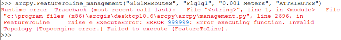
By using closest facility, I found closest path between 78 points. Now, I am trying to split this route at intersection points by using feature to line management tool. However, I am getting a Topoengine error. What I tried to solve this problem is that :
1. I used repair geometry.
2. I used check geometry.
3. I unchecked background processing from geoprocessing option.
4. I copied the data to new file geodatabase.
But, I could not fix this problem. If you have any suggestion to me, I will be appreciated for that.
Thanks !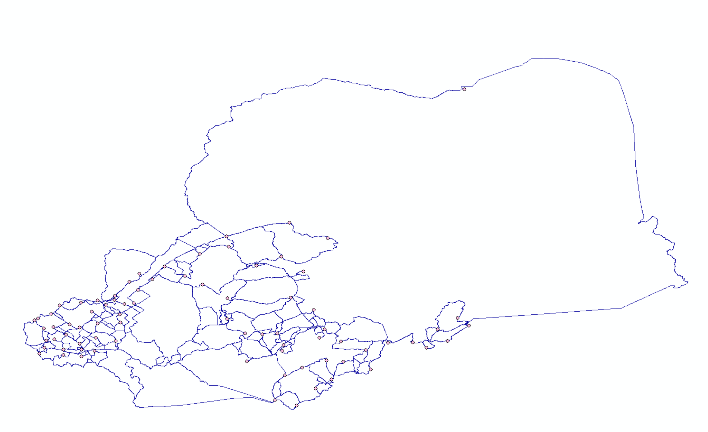
- Mark as New
- Bookmark
- Subscribe
- Mute
- Subscribe to RSS Feed
- Permalink
I believe this data is for "display". It is not really suitable for routing.
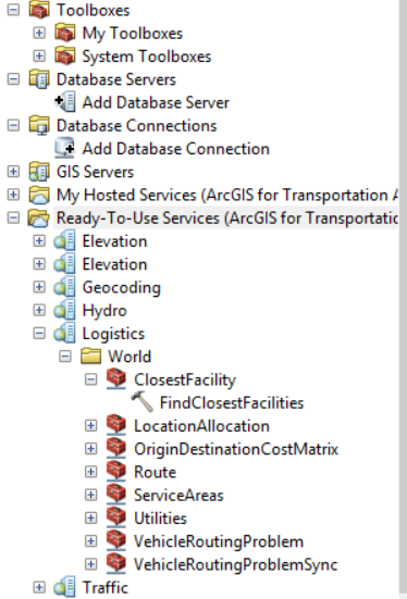
If you have an AGOL account and credits, you can use the online closest facility service and get routes with current street network. You can access this from the Ready To Use services in ArcCatalog.
Consuming the logistics services using ArcMap—Help | ArcGIS Desktop
Jay Sandhu
- Mark as New
- Bookmark
- Subscribe
- Mute
- Subscribe to RSS Feed
- Permalink
Why do you think that it is not suitable for routing ? After exporting this data as shapefile, I created Network Analysis.
Actually, I have 234 CSD coordinates but since this program gave me a error, I decided to split my data into three excel file as 78 CSD coordinates. Do you think that can I find shorthest path between 234 CSD coordinates by using this online closest facility service ?
I saw Ready to Use Service, I signed up with my community esri account, but I could not see like what you are seeing in the Picture above. Is this online ArcGis ?
I need to purchase, right ? I saw monthly pricing.
Do you think that is this better to use rather than using route network file ?
Before that, I was studying on Road network files . Do you think that is this file suitable ?
Sorry for asking too many questions. I am appreciated for your help. !!
Thank you so much!!
- Mark as New
- Bookmark
- Subscribe
- Mute
- Subscribe to RSS Feed
- Permalink
>Why do you think that it is not suitable for routing?
This data does not contain any information on transportation related attribute such as drive times, speed limits, one-way information, turn restrictions, how the ramps connect (z-levels), etc. If you create topology and flatten out these intersections then you will get wrong paths. There are many other things needed to make a meaningful road network.
You also mention:
>I was studying on Road network files
If you see the information on that web page, it says: "these files are not suitable for engineering applications, emergency dispatching services, surveying or legal applications"
So it depends on what is your use case for the routes you are creating.
As far as ArcGIS online, you could create a new trail account and try out these ready to use services. It comes with some limited amount of credits. More information here:
ArcGIS Trial | Free 21-Day Trial
Jay Sandhu
- Mark as New
- Bookmark
- Subscribe
- Mute
- Subscribe to RSS Feed
- Permalink
Thank you so much for your answer !. I am appreciated for that. I did what you suggest to me.
These are the steps that I followed :
1. I signed up ArcGis Trial.
2. Then, I used closest facility from ready to use services.
3. I found shorthest path between 78 CSD coordinates.
4. I exported this shorthest path.
5. I applied feature to line management tool to split line at their intersection points.
6. I got an same error saying that invalid topology (topoengine error).
- Mark as New
- Bookmark
- Subscribe
- Mute
- Subscribe to RSS Feed
- Permalink
I really do not understand why I have to use Online ArcGis. I can find shorthest path between points by using North America Major Highway. But, my porblem is coming when I appyly feature to line tool to the shorthest path.
Thank you so much!!
I am appreciated.
- « Previous
-
- 1
- 2
- Next »
- « Previous
-
- 1
- 2
- Next »