Turn on suggestions
Auto-suggest helps you quickly narrow down your search results by suggesting possible matches as you type.
Cancel
- Home
- :
- All Communities
- :
- Products
- :
- ArcGIS Network Analyst
- :
- ArcGIS Network Analyst Questions
- :
- Stops not properly located on edge
Options
- Subscribe to RSS Feed
- Mark Topic as New
- Mark Topic as Read
- Float this Topic for Current User
- Bookmark
- Subscribe
- Mute
- Printer Friendly Page
Stops not properly located on edge
Subscribe
2838
4
03-20-2013 05:57 AM
03-20-2013
05:57 AM
- Mark as New
- Bookmark
- Subscribe
- Mute
- Subscribe to RSS Feed
- Permalink
Hello Everyone,
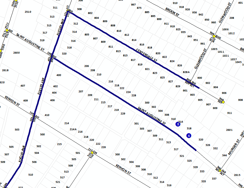
We are experiencing an issue where stops are not being located properly along a network edge. The attached picture is a great example of the issues we are having.
The image shows stops 5 and 6. Stop 6 is properly located along Saint Augustine St whereas stop 5 is being incorrectly located along Centerdale St. The determining factor for this appears to be the stops offset from Saint Augustine St. However, this issue only arises on random streets.
[ATTACH=CONFIG]22786[/ATTACH]
This occurs while using the defualt settings for the "Network Locations" tab (snap to closest, search tolerance 5000 m). It also occurs if we adjust these values.
We are using distance as the cost.
Any help would be greatly appreciated.
4 Replies
03-20-2013
09:48 AM
- Mark as New
- Bookmark
- Subscribe
- Mute
- Subscribe to RSS Feed
- Permalink
Given the screen shot, stop 5 should locate on the Saint Augustine street as it is closest to it. Can you make sure that you are locating using geometry and not by location fields? Also make sure you do not have "Exclude restricted portions of the network" turned on (network locations tab). You can interactively check where things are snapping by making sure the NA Window is open and the stop 5 is selected and then press the number 1 key. It will flash where the stop 5 is snapping to. You can drag the stop 5 around and keep on clicking the number 1 key to see where it snaps to. Perhaps that will give a clue to what is going on.
Jay Sandhu
Jay Sandhu
03-20-2013
09:55 AM
- Mark as New
- Bookmark
- Subscribe
- Mute
- Subscribe to RSS Feed
- Permalink
Thanks Jay,
I did a bit of additional testing right after having posted this issue and may have found the cause. I exported the feature dataset out to a file geodatbase (to avoid user locks.) I noticed that we had built the network using elevation values derived from the geometry of our street centerlines. I deleted the existing network and rebuilt it without using z values.................................... and the issue was resolved 🙂
Not sure why this is the case. I looked at the z-values from the street centerline geometry and all appears to be fine. There are no major discrepencies or severe changes in elevation along the give streets.
I won't know for sure if this is the true cause/fix for my issue until I replicate the process in our production database. I will be ure to post once we have a chance to try it out.
Thanks again for you response - we truly appreciate the assistance,
Shaun
03-21-2013
10:07 AM
- Mark as New
- Bookmark
- Subscribe
- Mute
- Subscribe to RSS Feed
- Permalink
Yes, 3D geometry can cause that! Network Analyst supports 3D data but the problem is that ArcMap is a 2D app. So if stops are in 2D with elevation 0 and they are being located to the closest 3D edge and if some edges have 0 elevation, they may be closer in 3D space. So the fix is to either make sure the street data is 2D or make sure the stops are in 3D! If you do have 3D stops then you can use the AddLocations tool to add stops to a route analysis layer. (Note there is no way to use a mouse click in ArcMap and get a 3D location).
Jay Sandhu
Jay Sandhu
03-21-2013
01:01 PM
- Mark as New
- Bookmark
- Subscribe
- Mute
- Subscribe to RSS Feed
- Permalink
Jay,
Thank you for the clarification! I was trying to understand the relationship but was not getting very far. This reenforces the decision the remove the elevtaion data from the network properties.
We are rebuilding our network this evening. Fingers crossed!
Thanks again Jay,
Shaun
Thank you for the clarification! I was trying to understand the relationship but was not getting very far. This reenforces the decision the remove the elevtaion data from the network properties.
We are rebuilding our network this evening. Fingers crossed!
Thanks again Jay,
Shaun