- Home
- :
- All Communities
- :
- Products
- :
- ArcGIS Network Analyst
- :
- ArcGIS Network Analyst Questions
- :
- Re: service area
- Subscribe to RSS Feed
- Mark Topic as New
- Mark Topic as Read
- Float this Topic for Current User
- Bookmark
- Subscribe
- Mute
- Printer Friendly Page
- Mark as New
- Bookmark
- Subscribe
- Mute
- Subscribe to RSS Feed
- Permalink
Buongiorno
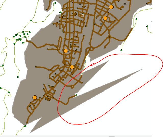
I am trying to use network analysis - service area - to create a polygon based on distance, for example 1000 meters.
In my case, dot = schools. So I want to see an area covered by 1000 meters.
There's one thing I can't understand... Why does it generate some weird clippings? as in the photo
Thank you so much!
Thai
serviceareapolygonsnetworkanalysis footprint polygon nearest distance
Solved! Go to Solution.
- Mark as New
- Bookmark
- Subscribe
- Mute
- Subscribe to RSS Feed
- Permalink
From this video, I see that your network dataset has an unknown spatial reference. This could also be part of the problem. You should always give your data a spatial reference.
- Mark as New
- Bookmark
- Subscribe
- Mute
- Subscribe to RSS Feed
- Permalink
Hi Melinda,
sorry for my delay, in this period we have been work with many urban themes to the new Urban plan
many thanks for your support...yes, 'unknown spatial reference' was the problem.
Thanks
- « Previous
-
- 1
- 2
- Next »
- « Previous
-
- 1
- 2
- Next »