Turn on suggestions
Auto-suggest helps you quickly narrow down your search results by suggesting possible matches as you type.
Cancel
- Home
- :
- All Communities
- :
- Products
- :
- ArcGIS Network Analyst
- :
- ArcGIS Network Analyst Questions
- :
- Service Area Weird Polygons
Options
- Subscribe to RSS Feed
- Mark Topic as New
- Mark Topic as Read
- Float this Topic for Current User
- Bookmark
- Subscribe
- Mute
- Printer Friendly Page
Service Area Weird Polygons
Subscribe
2662
1
04-15-2013 02:46 PM
04-15-2013
02:46 PM
- Mark as New
- Bookmark
- Subscribe
- Mute
- Subscribe to RSS Feed
- Permalink
Hi there,
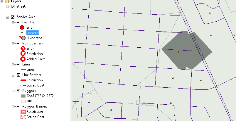
I am trying to create service area polygons for census block centroids within a city. I used 800 metres as the default break but one of my polygons came out looking very strange with a distance of 92 metres (which is smaller than the default break). Please find the screenshot below. Could anyone help me to figure out the problem? Many thanks in advance.
[ATTACH=CONFIG]23533[/ATTACH]
1 Reply
04-16-2013
04:29 AM
- Mark as New
- Bookmark
- Subscribe
- Mute
- Subscribe to RSS Feed
- Permalink
Hi there,
I am trying to create service area polygons for census block centroids within a city. I used 800 metres as the default break but one of my polygons came out looking very strange with a distance of 92 metres (which is smaller than the default break). Please find the screenshot below. Could anyone help me to figure out the problem? Many thanks in advance.
[ATTACH=CONFIG]23533[/ATTACH]
Looks okay to me given the fact that your street is not connected to the rest of the network.
That should just about do it....