- Home
- :
- All Communities
- :
- Products
- :
- ArcGIS Network Analyst
- :
- ArcGIS Network Analyst Questions
- :
- Service Area polygons are jagged
- Subscribe to RSS Feed
- Mark Topic as New
- Mark Topic as Read
- Float this Topic for Current User
- Bookmark
- Subscribe
- Mute
- Printer Friendly Page
- Mark as New
- Bookmark
- Subscribe
- Mute
- Subscribe to RSS Feed
- Permalink
In support of fire department deployment planning I'm generating Service Areas with the "Ready to Run Tools" in Pro 2.4.1.
SETTINGS: Not Overlapping, Rings, Standard Detail, 300 ft clipping
I've post-processed the results by clipping them to within 300 feet from my local roads dataset (to get rid of bogus fills in areas without roads).
PROBLEM: In an area that contains a divided roadway the polygon boundaries are unacceptably jagged (see screen shot).
1) Is there any way to improve the appearance of these polygon boundaries? I've tried the "High" detail and that doesn't appear significantly better.
2) I'd REALLY prefer to sidestep these polygon issues entirely by having an output type of "line", rather than polygon. It appears this is an option that went away; is there any plan to bring that functionality back in Pro?
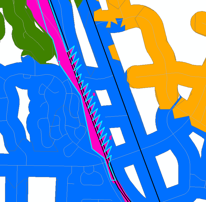
To speak more broadly about this, it appears that the "Generate Service Areas" tool really works well if you are in a large urban area with regular street patterns, but has many problems in rural areas when it comes to the details of polygon generation at a fine scale. Filling in areas that are surrounded by roads (like a big lake) and creating these jagged polygon boundaries create a problem of perception when I show the results to customers. If the results look weird, the customers doubt the accuracy of the result.
Thanks
Washoe County GIS
Solved! Go to Solution.
Accepted Solutions
- Mark as New
- Bookmark
- Subscribe
- Mute
- Subscribe to RSS Feed
- Permalink
Hi Jay,
With the last ArcGIS Online update, we added the ability to generate lines from a service area when using arcgis.com as your network dataset source. For right now, the only way to generate lines from the Service Area service is to do it from the Ready-to-Use tool Generate Service Area, which it sounds like you're using. With ArcGIS Pro 2.5, you'll be able to choose to generate lines when using a Service Area layer and the Service Area ribbon, even when using arcgis.com as the network dataset source.
Keep in mind that there is a limit for line generation. You can see the limits here Service Area service with asynchronous execution—ArcGIS REST API: Directions and Routing Services | ... in the Usage Limits section.
I hope this helps!
-Rachel
- Mark as New
- Bookmark
- Subscribe
- Mute
- Subscribe to RSS Feed
- Permalink
Rachel,
Thanks - that is exciting news and definitely helps with the issues I described above.
Jay
Washoe County GIS