- Home
- :
- All Communities
- :
- Products
- :
- ArcGIS Network Analyst
- :
- ArcGIS Network Analyst Questions
- :
- Create Address Locator with HERE/Navstreets Data
- Subscribe to RSS Feed
- Mark Topic as New
- Mark Topic as Read
- Float this Topic for Current User
- Bookmark
- Subscribe
- Mute
- Printer Friendly Page
Create Address Locator with HERE/Navstreets Data
- Mark as New
- Bookmark
- Subscribe
- Mute
- Subscribe to RSS Feed
- Permalink
Hai,
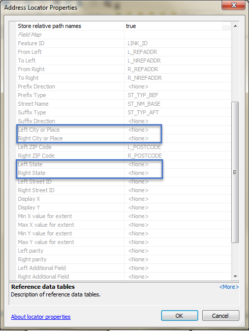
I just create Address Locator by using Streets feature class from HERE data.

But, in this HERE data, Streets Feature Class not have field for City and State. If you notice, Left City or Place. Right City or Place, Left State and Right State is blank.
- Mark as New
- Bookmark
- Subscribe
- Mute
- Subscribe to RSS Feed
- Permalink
Are these AdminBody# feature classes polygons? Are they the cities and states you desire? If so, you can do a series of spatial joins to get the polygon data on to your centerline data. Or you can do it manually by selecting the polygon you want and calculating the approriate field(s) on your centerlines.
- Mark as New
- Bookmark
- Subscribe
- Mute
- Subscribe to RSS Feed
- Permalink
Hello
You will need to dig into the data model for HERE's raw supply and figure out where to get the left and right city and state names. My first guess is the ADMINID field will join the streets to the Admin table where ORDER1_NAME will be State and ORDER8_NAME will be City but I'm very rusty on this.