- Home
- :
- All Communities
- :
- Products
- :
- ArcGIS Network Analyst
- :
- ArcGIS Network Analyst Questions
- :
- Configuring Historical Traffic (ARCMAP 10.2.2)
- Subscribe to RSS Feed
- Mark Topic as New
- Mark Topic as Read
- Float this Topic for Current User
- Bookmark
- Subscribe
- Mute
- Printer Friendly Page
Configuring Historical Traffic (ARCMAP 10.2.2)
- Mark as New
- Bookmark
- Subscribe
- Mute
- Subscribe to RSS Feed
- Permalink
Dear All,
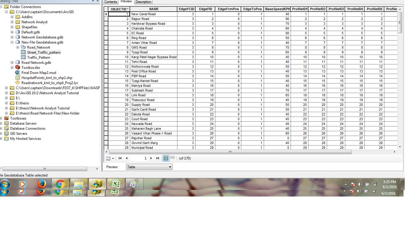
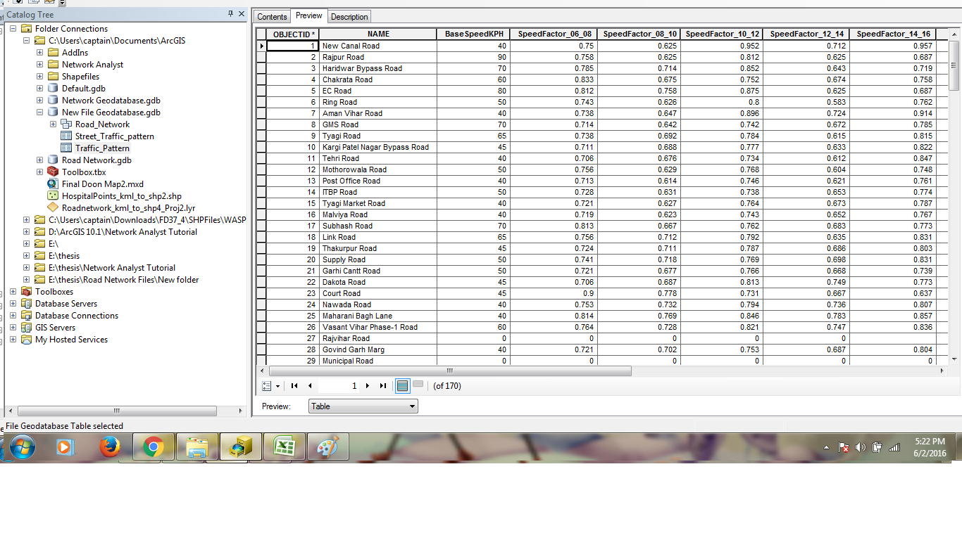
I am having difficulty configuring historical traffic within my Geodatabase. I had mentioned in a previous post regarding this issue but was unable to attach a zipped file or access the advanced editor, hence i am having to repost the thread. The area is taken from a small portion of roads clipped out of a Road Network as an area of interest. Please find attached the feature class table, as well as the Street_DailyProfiles and DailyProfiles table.
Regards
Ali
- Mark as New
- Bookmark
- Subscribe
- Mute
- Subscribe to RSS Feed
- Permalink
I m also suffering from this problem, if u have found any solution, please tell here and also i want to know from you that how to find the network Id and EdgeFID attribute for the street daily profile. i'll be highly thankful to you.
With Regards,
- Mark as New
- Bookmark
- Subscribe
- Mute
- Subscribe to RSS Feed
- Permalink
Hi,
Take a look at the next diagram, it might be helpful:

The Edge FCID can be found in the ArcCatalog ==> the Network's Streets Feature Class properties ==> General tab ==> three points next to the Name:

Good luck,
Asaf.
- Mark as New
- Bookmark
- Subscribe
- Mute
- Subscribe to RSS Feed
- Permalink
@ASAF,
Thank you so much for your help. I have a question in my mind can i use object ID field value from profile table into the EdgeFID field of Join table.
Additionally, I have been trying to create a network dataset with a street feature and these two required tables, but at the time of creation it is not asking for any historical data. Can you suggest me that what can be the possible problem. I have attached these
tables, please have a look.
With Thanks.
- Mark as New
- Bookmark
- Subscribe
- Mute
- Subscribe to RSS Feed
- Permalink
Pranav,
The Historical Traffic data (with its 2 related tables) has to be in a very specific form. That means that all the names and even more important, the fields format has to be the same as you will find in the next link:
http://www.arcgis.com/home/item.html?id=e11126ea20e941bd9644046e62e2bdbe
When that will be done, and the tables of course will be in your other network's data GDB, The "New Network Dataset" wizard will add an extra step for the Historical Data configuration.
Asaf.
- Mark as New
- Bookmark
- Subscribe
- Mute
- Subscribe to RSS Feed
- Permalink
Thank you Asaf,
I got the point, but one of my question remains the same, that EdgeFID
value can be filled with objectID value or not and if not how to calculate
it. I know about FCID value but I have a doubt over FID.
And secondly, my field format are not the same as given in Arcgis tutorial,
becoz when I was loading my data for these tables it is matching with the
field only when all field's format is "double". Can you please help me on
this two issue.
I am really thankful to your help.
Thanks a ton.
With Thanks.
- Mark as New
- Bookmark
- Subscribe
- Mute
- Subscribe to RSS Feed
- Permalink
Look at the tables diagram I attached before (try to enlarge it). The EdgeFID in the Join table is the Object ID of the Streets FC (this table relates the right profile to the corresponding street segment).
- Mark as New
- Bookmark
- Subscribe
- Mute
- Subscribe to RSS Feed
- Permalink
For your second question, I think that the easiest solution is to copy the table from the link above (http://www.arcgis.com/home/item.html?id=e11126ea20e941bd9644046e62e2bdbe) empty it (Truncate Table), and then load your own data.
Asaf.
- Mark as New
- Bookmark
- Subscribe
- Mute
- Subscribe to RSS Feed
- Permalink
Asaf,
I am really thankful to you, you have cleared my doubts, your idea sounds well, i'll work as you have suggested.
Thank you so much!!
Pranav Gairola
- Mark as New
- Bookmark
- Subscribe
- Mute
- Subscribe to RSS Feed
- Permalink
Hey Asaf,
can you explain me that why the street profile table is taking values only for the fields having datatype as double, for integer values it is not loading any value at all, However, it is modelling historical traffic with this table but errors are there as some values are missing. So can you tell me how this can be resolved.
Regards,
Pranav gairola