- Home
- :
- All Communities
- :
- Products
- :
- ArcGIS Network Analyst
- :
- ArcGIS Network Analyst Questions
- :
- Can stops be automatically restricted from snappin...
- Subscribe to RSS Feed
- Mark Topic as New
- Mark Topic as Read
- Float this Topic for Current User
- Bookmark
- Subscribe
- Mute
- Printer Friendly Page
Can stops be automatically restricted from snapping to a certain part of a network?
- Mark as New
- Bookmark
- Subscribe
- Mute
- Subscribe to RSS Feed
- Permalink
I do a lot of analysis with routing and ridership, and I run into this problem regularly. Let's say there are 5 addresses on a cul-de-sac and one of the houses back up to an interstate. If I create a route and use these addresses as stops, Network Analyst believes 1 address is on the interstate and routes equipment to the interstate.
Is there a way to use the interstate for routing purposes, but restrict stops from being placed on the closest road? I'm dealing with about 45,000 addresses. I provided an example of this problem. There are points (these are all random) and the closest to I-95, not the neighborhood street, so it assigns these points to the wrong facility.
Based on the picture you may ask, "why not just draw a service road these addresses and that would be used during the analysis." That would be ok, except I'm dealing with about 45,000 points and I don't maintain the centerline layer.
Solved! Go to Solution.
Accepted Solutions
- Mark as New
- Bookmark
- Subscribe
- Mute
- Subscribe to RSS Feed
- Permalink
This is an interesting question. I don't know the exact answer offhand, but I did find some ideas on StackExchange that look like they would work:
Also, let me tag someone who may already know a way to solve this, as he does emergency response routing with Network Analyst: jborgion
Chris Donohue, GISP
- Mark as New
- Bookmark
- Subscribe
- Mute
- Subscribe to RSS Feed
- Permalink
This is quite a problem, but I've never actually seen in manifested in the routing I've done. I've actually moved on from the 9-1-1 scene so I can't look at how I set things up.
- Mark as New
- Bookmark
- Subscribe
- Mute
- Subscribe to RSS Feed
- Permalink
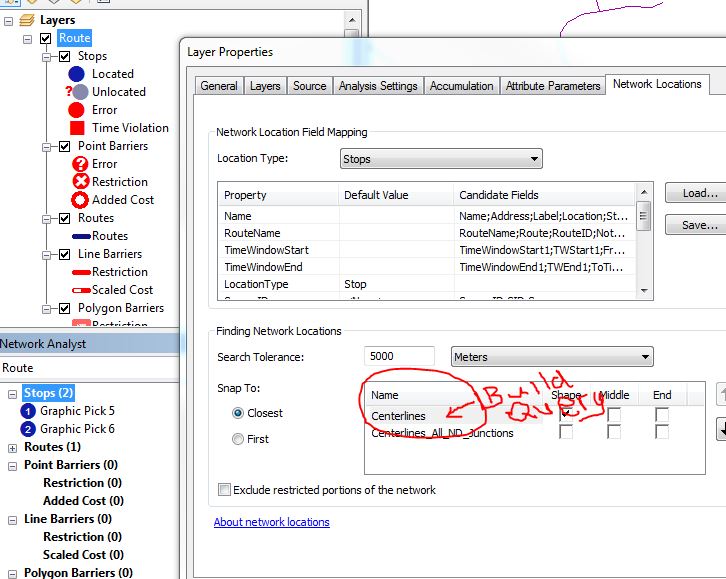
You can control the stop locations by specifying a query on what line features to exclude. To do that, on the route analysis properties, click on the Network Locations tab and then in the Snap To area, right-click on the Streets feature to bring up the Build Query dialog. Then specify the query. For example with the San Fran tutorial data, I could specify NET2CLASS > 1 to not locate on any highway.
You can read more about this capability in the "Snapping environment with Build Query" section here:
What are network analysis objects?—Help | ArcGIS Desktop
Jay Sandhu
- Mark as New
- Bookmark
- Subscribe
- Mute
- Subscribe to RSS Feed
- Permalink
Hey Jay- I'm curious about this; I could specify NET2CLASS > 1 to not locate on any highway.
Obviously plenty of incidents are in fact on a freeway; would this approach effect those or would it?
- Mark as New
- Bookmark
- Subscribe
- Mute
- Subscribe to RSS Feed
- Permalink
Joe,
The NET2CLASS > 1 will not locate on any feature that is a highway. It was an example of what/how a query could be specified. If you have data that does snap on highways, you should use some other type of query based on your data. But if your application is residential deliveries, then excluding features of type ramps, highways, etc., should be useful!
Jay
- Mark as New
- Bookmark
- Subscribe
- Mute
- Subscribe to RSS Feed
- Permalink
Thanks for everyone's suggestions. Despite having many years of experience creating network, I never had a need to restrict some stops to certain parts of the network. Even though this restriction should have been anticipated.
For the newbies out there, here's how I solved this problem. From my centerline file I made a new column called StopRestrict. If 0, a stop can be placed on the road, if 1 then the stop cannon be placed on the road. Then, on my stop layer (from a new route analysis), select the centerline layer and build a query where StopRestrict = 0. I included a screenshot.
Again, I cannot believe I didn't know this. Thanks for everyone's help!
Doug