- Home
- :
- All Communities
- :
- Products
- :
- Mapping and Charting Solutions
- :
- Mapping and Charting Questions
- :
- Re: How to... convert overlay grid to features?
- Subscribe to RSS Feed
- Mark Topic as New
- Mark Topic as Read
- Float this Topic for Current User
- Bookmark
- Subscribe
- Mute
- Printer Friendly Page
How to... convert overlay grid to features?
- Mark as New
- Bookmark
- Subscribe
- Mute
- Subscribe to RSS Feed
- Permalink
- Report Inappropriate Content
Dear reader,
I have created and overlay Grid with the Grids and Graticules Wizard in the Layout View.
Looks great now, but I want to use that Grid to do some indexing on my Streets and Places feature layers.
Like:
Street 1 C14
Street 2 K25
Place A B4
etc
But I do not see and could not find any solution.
What am I missing?
Should I convert my overlay Grid?
Should I use other functionallity?
Combining Grid Index Features and the grid from the Grids and Graticules Wizard is not really an option....?
Thanks for your time and reply in advance 😉
Using: ArcGIS ArcMap 10.4.1 Standard license
- Mark as New
- Bookmark
- Subscribe
- Mute
- Subscribe to RSS Feed
- Permalink
- Report Inappropriate Content
If I every need a grid pattern... Fishnet
- Mark as New
- Bookmark
- Subscribe
- Mute
- Subscribe to RSS Feed
- Permalink
- Report Inappropriate Content
Fishnet as Dan say, also try Grid Index Features—Help | ArcGIS Desktop , then use Spatial Join—Help | ArcGIS Desktop for Grid and streets layers.
- Mark as New
- Bookmark
- Subscribe
- Mute
- Subscribe to RSS Feed
- Permalink
- Report Inappropriate Content
Dan_Patterson and @Abdullah Anter : thank you both for your replies.
Those options I am familiar with.
But if you have created a fishnet how do you use that as an overlay like the option of a Grids and Graticules Measured Grid? Is there a way to combine those two ?
- Mark as New
- Bookmark
- Subscribe
- Mute
- Subscribe to RSS Feed
- Permalink
- Report Inappropriate Content
As a polyline or polygon... you wanted to use it for indexing... you could spatially join or perhaps intersect to pull your attributes over to the fishnet. Xander Bakker posted some code sample for labelling the fishnet in variety of ways, I can't put my hands on it at present. Of course, rectangles and squares are so yesterday... you could mess with those and other shapes as well  Phishnyet creating sampling grids using numpy
- Mark as New
- Bookmark
- Subscribe
- Mute
- Subscribe to RSS Feed
- Permalink
- Report Inappropriate Content
There are two that I can remember:
How can I assign grid values to the squares of a fishnet grid?
... and the hexagon example:
How do I create and display the row and column of a hexagon grid
... and Dan_Patterson himself has an example here:
- Mark as New
- Bookmark
- Subscribe
- Mute
- Subscribe to RSS Feed
- Permalink
- Report Inappropriate Content
forgot about that one... that was during my 2 space indentation phase
- Mark as New
- Bookmark
- Subscribe
- Mute
- Subscribe to RSS Feed
- Permalink
- Report Inappropriate Content
, then use Spatial Join—Help | ArcGIS Desktop for Grid and streets layers.
- Mark as New
- Bookmark
- Subscribe
- Mute
- Subscribe to RSS Feed
- Permalink
- Report Inappropriate Content
Dan Patterson and Abdullah Anter thanks for your replies.
I know your tips. But it is still not what I want, my client actually 😉
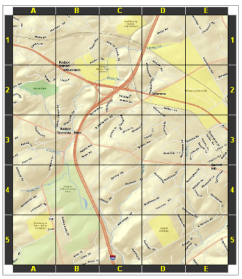
In the help on the grids and graticules topic shows the first image what I have created:
http://desktop.arcgis.com/en/arcmap/10.3/map/page-layouts/GUID-9D4FC69A-69CF-43F5-8195-D92500A5C8B5-...
Then it says: " Often, the row and column labels of a reference grid identify locations listed in a map index"
And my question then is: how ?
Maybe using the "custom overlay reference grids" option...?
- Mark as New
- Bookmark
- Subscribe
- Mute
- Subscribe to RSS Feed
- Permalink
- Report Inappropriate Content
Did you find a solution to this? I'm trying to do the same thing now but I can't get my head around it.