- Home
- :
- All Communities
- :
- Products
- :
- Mapping and Charting Solutions
- :
- Mapping and Charting Questions
- :
- Re: which Coordinate Reference System (CRS) and/or...
- Subscribe to RSS Feed
- Mark Topic as New
- Mark Topic as Read
- Float this Topic for Current User
- Bookmark
- Subscribe
- Mute
- Printer Friendly Page
which Coordinate Reference System (CRS) and/or Projection?
- Mark as New
- Bookmark
- Subscribe
- Mute
- Subscribe to RSS Feed
- Permalink
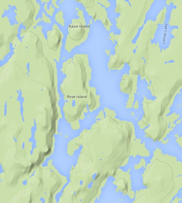
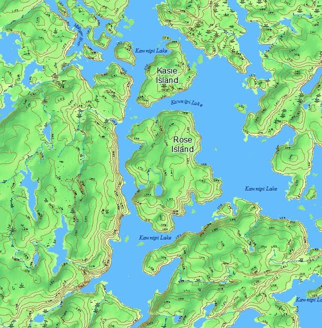
The images of below are from my map and from another online topo map. All the maps I have checked show Rose Island long and skinny like it does in the first map below. I think the Coordinate Reference System (CRS) or the Projection on my map is not correct. I am using ArcMap If I change the CRS, to UTM NAD 83 Zone 15, then Rose Island will look like it does on the first map, however, the data source says that the CRS for the data is: NAD83 (EPSG:4269) EPSG which is what my map is set to.
ArcMap shows my Data Frame and my vector data layers as below:
GCS_North_American_1983
WKID: 4269 Authority: EPSG
Angular Unit: Degree (0.0174532925199433)
Prime Meridian: Greenwich (0.0)
Datum: D_North_American_1983
Spheroid: GRS_1980
Semimajor Axis: 6378137.0
Semiminor Axis: 6356752.314140356
Inverse Flattening: 298.257222101
I would think that the information supplied with the vector data specifying the CRS would be correct but the shape doesn't seem right.
I assume all the online and printed maps that I have checked are displaying Rose Island in the correct long and skinny shape. Should I change the CRS on my map to make the Island look the way it does on other maps?
Also, I am new at this and I'm not sure what the difference is between CRS and "Projection" are they the same? Or, maybe I have the CRS correct and the Projection wrong?
All the printed and online maps that I checked show Rose Island as below.

Below is my map with CRS GCS_North_American_1983 WKID: 4269 Authority: EPSG

Solved! Go to Solution.
- Mark as New
- Bookmark
- Subscribe
- Mute
- Subscribe to RSS Feed
- Permalink
Thank you Dan and Melita for all your help. I think the problem is that there is a small part of the map that
is based on a different coordinate system. I will look for different data. I used the Define Projection tool to make all the layers 4269, as most of the layers are supposed to be, and the map looked correct until I Defined the Projection of the data frame to 4269, then the map got out of shape, so, for now, I will leave the data frame with a different projection than all the layers. Data Frame is NAD_1983_UTM_Zone_15N WKID: 26915 Authority: EPSG. I plan to study this more and at some point, re-do the map correctly.
- « Previous
-
- 1
- 2
- Next »
- « Previous
-
- 1
- 2
- Next »