- Home
- :
- All Communities
- :
- Products
- :
- Mapping and Charting Solutions
- :
- Mapping and Charting Questions
- :
- How do I create a fishnet grid that aligns with a ...
- Subscribe to RSS Feed
- Mark Topic as New
- Mark Topic as Read
- Float this Topic for Current User
- Bookmark
- Subscribe
- Mute
- Printer Friendly Page
How do I create a fishnet grid that aligns with a 15 minute data frame grid?
- Mark as New
- Bookmark
- Subscribe
- Mute
- Subscribe to RSS Feed
- Permalink
I'm using ArcGIS 10.4.1. I need to create a grid that will allow me to join spatial data to cells, while also aligning with 15 minute marks on the perimeter. My biggest issue is the spacing between the latitudinal lines going south. I cannot get my fishnet to line up to the 15 minute marks, the grid is always just a bit off. Projection: WGS 84.
Is my projection incorrect? If so, what should it be?
Is it possible to create a fishnet with grids ever 15 minutes?
Do I need to reproject my fishnet to align to my 15 minute data frame grid? and if so, how do I reproject it?
Can I save my data frame grid as a shapefile or feature class to join spatial data to it?
I do not have access to Data Reviewer.
#create fishnet #grid format #esri services #support services blog #esri support site #help please
- Mark as New
- Bookmark
- Subscribe
- Mute
- Subscribe to RSS Feed
- Permalink
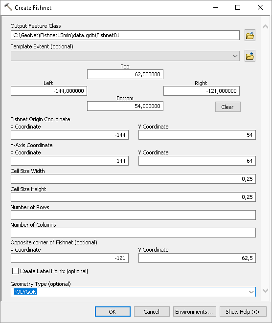
How did you create the Fishnet and what spatial reference is your dataframe using (is it GCS WGS 1984)? I just did a test:
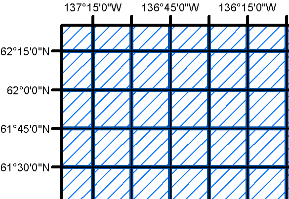
... and it seems to align correctly with a graticule in my layout: