- Home
- :
- All Communities
- :
- Products
- :
- Mapping and Charting Solutions
- :
- Mapping and Charting Questions
- :
- Re: Creating a map of defined Postcode Sectors
- Subscribe to RSS Feed
- Mark Topic as New
- Mark Topic as Read
- Float this Topic for Current User
- Bookmark
- Subscribe
- Mute
- Printer Friendly Page
Creating a map of defined Postcode Sectors
- Mark as New
- Bookmark
- Subscribe
- Mute
- Subscribe to RSS Feed
- Permalink
Hi all,
quick newbie question:
Is it possible to create a basemap of the UK showing only certain specific postcode areas:
- CB
- CO
- IP
- NR
- PE
- SG
- SM
- SS
I need to create this primarily to print and stick on the wall. To my constant shame!
Thanks
James
- Mark as New
- Bookmark
- Subscribe
- Mute
- Subscribe to RSS Feed
- Permalink
do you have the data? Or are you looking for it?
- Mark as New
- Bookmark
- Subscribe
- Mute
- Subscribe to RSS Feed
- Permalink
Hi Dan,
No, I don't have the data, other than those are the only postcode areas I'd like to display
- Mark as New
- Bookmark
- Subscribe
- Mute
- Subscribe to RSS Feed
- Permalink
You can download postcode sector data from the ONS website:
Office for National Statistics
Just search for poscode - there are two variations released each month - you'll have to search for the documentation if you want to read up about the differences but from your question it sounds like either will do; just go for the latest version.
- Mark as New
- Bookmark
- Subscribe
- Mute
- Subscribe to RSS Feed
- Permalink
Thanks Dan, that looks just the ticket!
- Mark as New
- Bookmark
- Subscribe
- Mute
- Subscribe to RSS Feed
- Permalink
Well ... I just googled and came up with a large number of hits. You can explore, but if you can even get the data in shapefile format that will be a start... for example, here is one link Data | Open Door Logistics
- Mark as New
- Bookmark
- Subscribe
- Mute
- Subscribe to RSS Feed
- Permalink
If you download the data from the link suggested by Dan (http://www.opendoorlogistics.com/wp-content/uploads/Data/UK-postcode-boundaries-Jan-2015.zip , do read the usage terms) there will be 3 shapefiles in the ZIP:
Areas, Districts and Sectors.
Depending on the level of detail required, you can directly use the areas using a definition query:
"name" in ('CB','CO','IP','NR','PE','SG','SM','SS')
For Districts and Sectors you will probably have to create an additional text field, fill it with: left( [name], 2) and then point the definition query shown above to that new field.
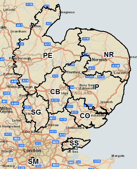
Example (areas in black, districts in blue and sectors in red with labels):

source: Open Door Logistics | Specialists in open source solutions for transport logistics
Areas:

source: Open Door Logistics | Specialists in open source solutions for transport logistics