- Home
- :
- All Communities
- :
- Products
- :
- ArcGIS Living Atlas of the World
- :
- Living Atlas Questions
- :
- USA NLCD Impervious Surface Time Series ImageServe...
- Subscribe to RSS Feed
- Mark Topic as New
- Mark Topic as Read
- Float this Topic for Current User
- Bookmark
- Subscribe
- Mute
- Printer Friendly Page
USA NLCD Impervious Surface Time Series ImageServer missing Northwestern US!
- Mark as New
- Bookmark
- Subscribe
- Mute
- Subscribe to RSS Feed
- Permalink
- Report Inappropriate Content
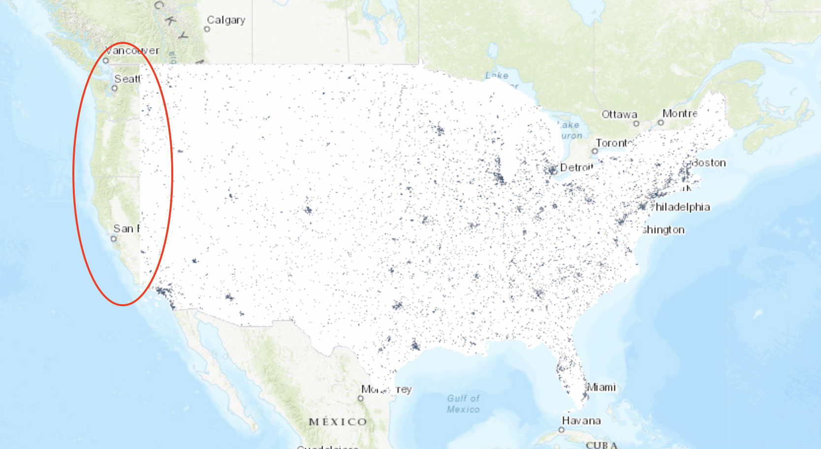
A huge swath of Northern/Central California, western Oregon and western Washington are missing from the "Authoritative" USA NLCD Impervious Surface Time Series Image Server. It is clearly visible in this map with all time series dates included. We use this layer for a ton of daily/dynamic processing in our org and lots of things are broken as of late as a result of this layers issues. Please advise.
- Mark as New
- Bookmark
- Subscribe
- Mute
- Subscribe to RSS Feed
- Permalink
- Report Inappropriate Content
I checked the image service, and it all seems to be working just fine. Here's the map I just viewed using that service:


I'd suggest the obvious - clear browser cache and give it another go.
- Mark as New
- Bookmark
- Subscribe
- Mute
- Subscribe to RSS Feed
- Permalink
- Report Inappropriate Content
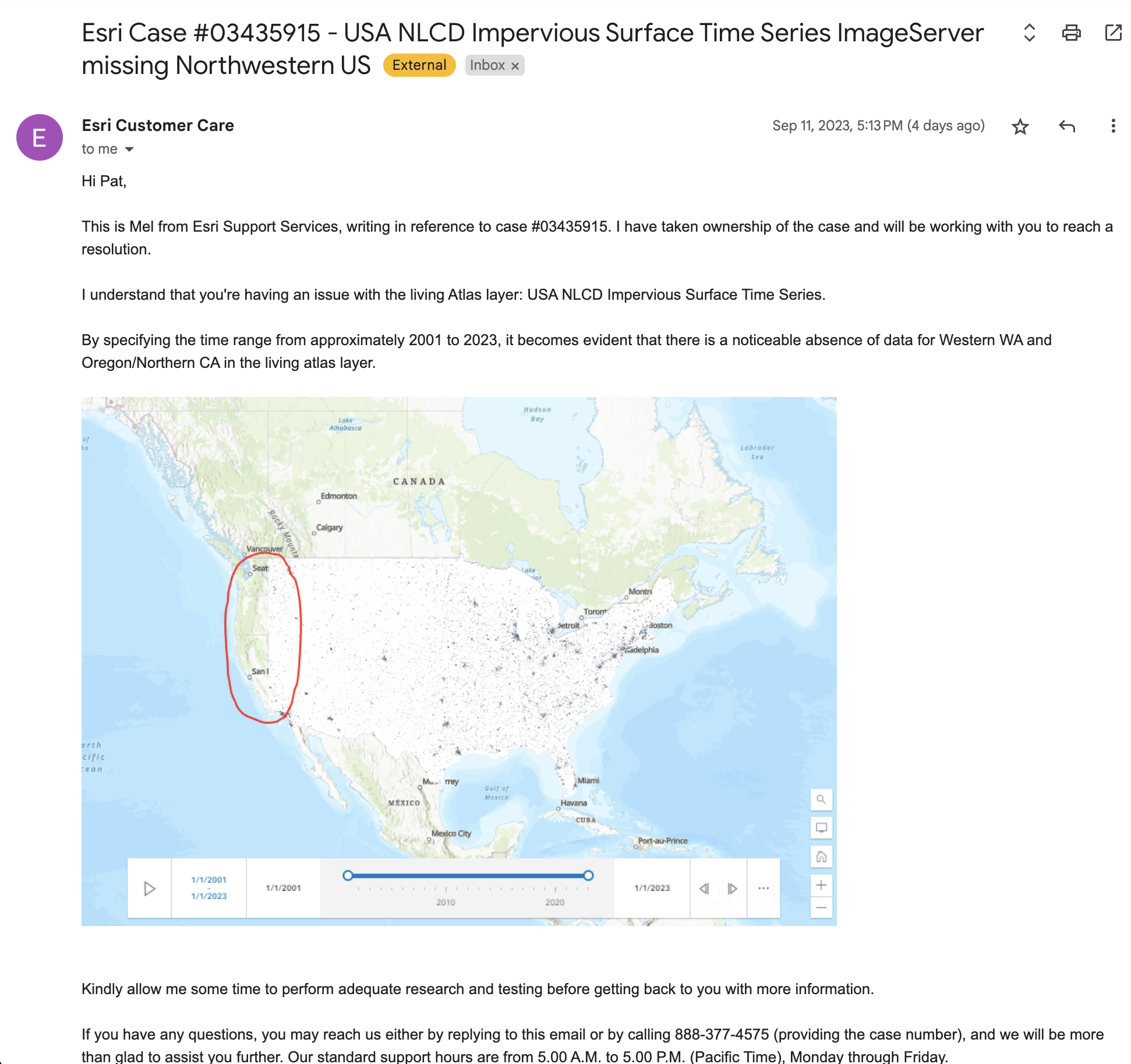
Hi Bernie - It was confirmed by Esri Agol staff to me that this service did in fact have the portion I showed missing for about a 3day period 9/9 to 9/12. It's since been fixed but I have yet to receive an answer for why an 'authoritative' layer had such a massive gap in coverage for that period. Bummer for any folks who use this layer for any kind of automated extraction process. Not having that reliability leave our org with two not great options 1) download and host the NLCD impervious layer ourselves 2) pray the esri living atlas layer doesn't glitch again. I have attached correspondence with tech support here confirming they could reproduce the issue I highlighted in the original post as of 9/11. Some clarification on what happened and what was done to remedy it would be appreciated.
- Mark as New
- Bookmark
- Subscribe
- Mute
- Subscribe to RSS Feed
- Permalink
- Report Inappropriate Content
A fair question. I'll see if I can look up your incident and see what went on behind the scenes.
- Mark as New
- Bookmark
- Subscribe
- Mute
- Subscribe to RSS Feed
- Permalink
- Report Inappropriate Content
I've gone back and reviewed your support incident and correspondence with the support analyst. I've also engaged the team in an effort to gain additional insight into that missing slice of geography. We do monitor the service, however the service did not fail so we were not alerted to any issues. That service is not updated with frequency, so it is curious that you experienced missing data - we've had no other issue reports on that service.
At this point I've exhausted what I can do to go back in time to gain additional information and am unable to provide you any additional insight on exactly what may have happened or how it resolved. Obviously should you see this again on your end, send us the request/response you see in the browser for review if possible.
- Mark as New
- Bookmark
- Subscribe
- Mute
- Subscribe to RSS Feed
- Permalink
- Report Inappropriate Content
Hi Bernie - Thanks for looking into it. So the correspondence I shared from the AGOL support analyst that they could also replicate the no data issue with the service at the time of this post and a bug ticket was submitted (9/11/23) was not true? From your research the service was working perfectly fine at the time that two separate parties, including esri support, confirmed it was not working perfectly fine?
- Mark as New
- Bookmark
- Subscribe
- Mute
- Subscribe to RSS Feed
- Permalink
- Report Inappropriate Content
Hello Pat - I just reviewed the correspondence from the support incident again. You are absolutely correct that on 9/11 a support analyst (maybe two as the case escalated and was handed off) confirmed they could repro the issue that you saw. After that on 9/12 the issue was no longer reproducible, and you agreed it looked fine again on your end of things.
As I mentioned previously, since the issue no longer exists it's impossible to figure out what exactly may have happened. The servers are monitored, but in this case the server did not have a complete fail - our monitoring would have caught that. However, as you documented and support concurred, during that period the image service seemed to be missing content at specific time ranges and LODs.
After checking directly with the team from my end, I will agree with the final communication from your support analyst on 9/14 stating the issue is no longer reproducible, the service is currently operating as expected, and it's not possible to figure out why there was a glitch during that time.
I'm expecting you're still not satisfied with this response, but I've exhausted what I am able to learn and help you with. Again, if you notice anything odd in the future, additional details about what you see in the browser request/response would provide a course for further investigation.
- Mark as New
- Bookmark
- Subscribe
- Mute
- Subscribe to RSS Feed
- Permalink
- Report Inappropriate Content
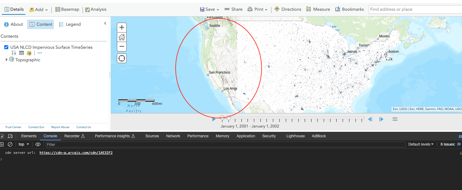
@BernSzukalski this issue appears to be happening again. Attached is the screen shot of what I see when opening living atlas NLCD impervious surface. No errors being logged to console but visually AND when I attempt to run zonal stats against image service for anywhere in western US there is no data to summarize.
- Mark as New
- Bookmark
- Subscribe
- Mute
- Subscribe to RSS Feed
- Permalink
- Report Inappropriate Content
Thanks for reporting, will have a look...
- Mark as New
- Bookmark
- Subscribe
- Mute
- Subscribe to RSS Feed
- Permalink
- Report Inappropriate Content
Also, please connect with technical support just so we can continue to follow up on this.