- Home
- :
- All Communities
- :
- Products
- :
- ArcGIS Living Atlas of the World
- :
- Living Atlas Questions
- :
- Is the USA Flood Risk Layer out of sync with the F...
- Subscribe to RSS Feed
- Mark Topic as New
- Mark Topic as Read
- Float this Topic for Current User
- Bookmark
- Subscribe
- Mute
- Printer Friendly Page
Is the USA Flood Risk Layer out of sync with the FEMA National Flood Hazard Layer?
- Mark as New
- Bookmark
- Subscribe
- Mute
- Subscribe to RSS Feed
- Permalink
Living Atlas Team -
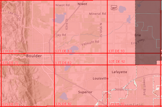
We noticed today that the US Flood Risk layer is missing areas for Boulder, Colorado. Is it possible that the US Flood Risk layer is out of sync with the FEMA National Flood Hazard Layer?
We were planning to use this layer during an upcoming flood exercise.
Esri Layer
www.arcgis.com/home/item.html?id=6b09b1c163c740559dc31cce9144222e
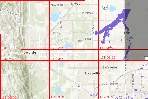
FEMA NHFL (Red indicates availability - zoom in to see detailed layer)
https://hazards.fema.gov/gis/nfhl/rest/services/public/NFHL/MapServer
Thank you for looking into this and please let us know what you find
pdoherty@publicsafetygis.org and tricec@bouldercolorado.gov
Solved! Go to Solution.
Accepted Solutions
- Mark as New
- Bookmark
- Subscribe
- Mute
- Subscribe to RSS Feed
- Permalink
Hi Paul,
Thanks for your inquiry. We are currently in discussion with FEMA about either updating our services on a more frequent basis, or retiring our services and showcasing FEMA's official web services in the Living Atlas. I am not sure how quickly we will get to a resolution, but in the meantime FEMA does have a service here public/NFHL (MapServer) which you can use.
hazards.fema.gov/gis/nfhl/rest/services/public/NFHL/MapServer
There is also this app: ArcGIS Web Application for downloading shapefiles
hazards-fema.maps.arcgis.com/apps/webappviewer/index.html?id=8b0adb51996444d4879338b5529aa9cd
But, this is on our radar, and we will do our best to work with FEMA to provide a valuable map and image service for our existing user base.
Thanks,
Caitlin
- Mark as New
- Bookmark
- Subscribe
- Mute
- Subscribe to RSS Feed
- Permalink
Thanks Caitlin for the prompt response we really appreciate it.
Since the NFHL layer that FEMA publishes only displays when zoomed in (large scale), we may have to re-host the data for visualization when zoomed out.
Keep up the great work, the Living Atlas is really curating a lot of great information for emergency managers.
- Mark as New
- Bookmark
- Subscribe
- Mute
- Subscribe to RSS Feed
- Permalink
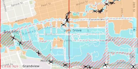
Hi, I know this is an old post, but I've noticed that this new layer USA Flood Hazard Areas layer is also missing areas when compared to the FEMA National Flood Hazard Layer. Is this still due to the less frequent updates?
Example of some areas where data is missing.
NFHL layer. The blue areas are mapped and have flood data.

ESRI USA Flood Hazard Areas layer. All of Clark County NV is missing.

Thanks,
Edward