- Home
- :
- All Communities
- :
- Developers
- :
- JavaScript Maps SDK
- :
- JavaScript Maps SDK Questions
- :
- Webapp- Show points within a selected polygon
- Subscribe to RSS Feed
- Mark Topic as New
- Mark Topic as Read
- Float this Topic for Current User
- Bookmark
- Subscribe
- Mute
- Printer Friendly Page
Webapp- Show points within a selected polygon
- Mark as New
- Bookmark
- Subscribe
- Mute
- Subscribe to RSS Feed
- Permalink
I have over 3 million points. I cannot have my server displaying all these points on a map a the same time.
What I want to do is when a building is selected, show all points within that polygon.
I know about this example:
Select with Feature Layer | ArcGIS API for JavaScript
I am not sure that will work because I don't want a buffer I want to use another Layer.
Thank you
Solved! Go to Solution.
Accepted Solutions
- Mark as New
- Bookmark
- Subscribe
- Mute
- Subscribe to RSS Feed
- Permalink
Yep you can use the same idea as the sample you linked to but instead of using a buffer you'll just use the geometry of the other layer. Here's an example that selects all the points within a census block group.
If you look at the code you'll see that we setup a click handler for the block feature layer and when its clicked we query the point feature layer using the clicked geometry.
- Mark as New
- Bookmark
- Subscribe
- Mute
- Subscribe to RSS Feed
- Permalink
That should work!
Thank you!
- Mark as New
- Bookmark
- Subscribe
- Mute
- Subscribe to RSS Feed
- Permalink
I was wondering if there is a way to have the selected census block highlighted as well?
It would be nice to know the boundary is for the block.
Is there a reason why when a geocoder is added it will not zoom to location?
Thank you!
- Mark as New
- Bookmark
- Subscribe
- Mute
- Subscribe to RSS Feed
- Permalink
That is exactly what I was looking for thank you!
- Mark as New
- Bookmark
- Subscribe
- Mute
- Subscribe to RSS Feed
- Permalink
So I am using polygons not points. Some polygons (soils) overlap some of the boundaries(taxlots).
For the life of me I cannot figure out how to change the color to indicate what polygon is selected(cyan outline).
It is confusing because there are so many features being selected.

The red taxlot is a boundary. Then two different features (soils) overlap that polygon are selected, indicated by a red dash.
When I select either polygon a cyan outline appears. This works when the map is zoomed out but when it is zoomed in it is impossible to tell what one is selected.
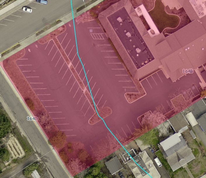
How do i change the color of the soils layer to indicate which one is selected?
Thank you
- Mark as New
- Bookmark
- Subscribe
- Mute
- Subscribe to RSS Feed
- Permalink
Rickey,
If I am understanding your concern then all you need to do is set the soil layer selection symbol. Look in the existing code for "setSelectionSymbol" for an example of the code syntax.
- Mark as New
- Bookmark
- Subscribe
- Mute
- Subscribe to RSS Feed
- Permalink
Robert,
Thank you for the quick reply!
I found the "setSelectionSymbol" you are talking about. When I add a color it changes the color of both polygons(soils) not the selected one.
// selection symbol used to draw the selected census block points within the buffer polygon
var symbol3 = new SimpleFillSymbol(SimpleFillSymbol.STYLE_SOLID,
new SimpleLineSymbol(SimpleLineSymbol.STYLE_DASHDOT,
new Color([247, 34, 101]), 2), new Color([247, 34, 101, 0.25]));
censusPoints.setSelectionSymbol(symbol3);
I am looking for the selected one (cyan border) to change fill color when selected.
- Mark as New
- Bookmark
- Subscribe
- Mute
- Subscribe to RSS Feed
- Permalink
Rickey,
You have do the setSelectionSymbol for the soils layer the cyan outline is the selection symbol.