- Home
- :
- All Communities
- :
- Developers
- :
- JavaScript Maps SDK
- :
- JavaScript Maps SDK Questions
- :
- Re: Public Notification: General JS Guidance... ge...
- Subscribe to RSS Feed
- Mark Topic as New
- Mark Topic as Read
- Float this Topic for Current User
- Bookmark
- Subscribe
- Mute
- Printer Friendly Page
Public Notification: General JS Guidance... geometry display and locator outSR
- Mark as New
- Bookmark
- Subscribe
- Mute
- Subscribe to RSS Feed
- Permalink
I have 2 issues with my public notification app that I think I understand, but I need some guidance going about fixing them...
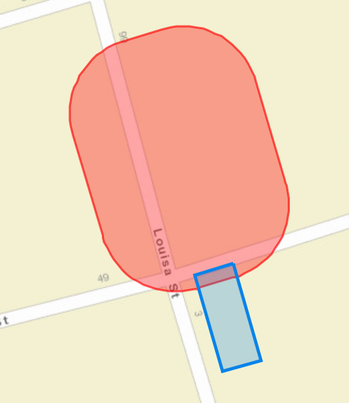
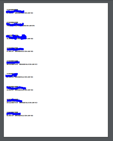
1) after selecting a parcel and choosing a buffer then executing the geoprocess... a buffer is drawn on the map, but only one property appears highlighted on the map (appears to just be the first returned), however the mailing labels and/or csv are complete with all the expected results of the buffer... its just not drawing them all on the map?!
Map Result
PDF Produced
2) the search query task works but when it goes to draw it on the map it doesnt reproject the layer. The service is published in UTM 17N. I believe the query just needs &outSR=102100 appended to it, but I am unsure how to go about this in the code for the locator widget.
its all internal so no link 
any help is appreciated.
Cheers
NOTE
Just to clarify the Public Notification app is a Local Government Template
Public Notification | ArcGIS for Local Government
Live demo
- Mark as New
- Bookmark
- Subscribe
- Mute
- Subscribe to RSS Feed
- Permalink
Hello Evan,
It would be really helpful, if you could share some code and also let us know which version of the api you are using.
1) From what you are explaining, it looks like you might be using same variable to create new graphic before adding it to map. So, it might be updating the same graphic and only the last graphic is visible on the map. Please share some code.
Regards,
Thejus
- Mark as New
- Bookmark
- Subscribe
- Mute
- Subscribe to RSS Feed
- Permalink
Thanks...
Just to clarify the Public Notification app is a Local Government Template
Public Notification | ArcGIS for Local Government
Live demo
The code is all default per the template, I just entered my services in the config.... and everything seems to work except these quirks I mentioned above...
My service shares all the results to create the pdf, but not to draw it on the map?
- Mark as New
- Bookmark
- Subscribe
- Mute
- Subscribe to RSS Feed
- Permalink
Hello Evan,
Were you able to resolve the issue?
What configuration do have for "parcelInformation.LowParcelIdentification" in config.js? If my understanding is correct, there will be only one graphic added to the map for each LowParcelIdentification id, whereas the result will be for all the features returned from the query. Does your data has the same value for that field?
~ Thejus
- Mark as New
- Bookmark
- Subscribe
- Mute
- Subscribe to RSS Feed
- Permalink
I've seen this before, but it's been a while, so I'm a little fuzzy on the fix. Is your basemap also in UTM 17N?
I know that all your layers and the basemap need to use the same coordinate system. I do not remember if that can be any coordinate system, or if it must be web mercator.
-Allison
- Mark as New
- Bookmark
- Subscribe
- Mute
- Subscribe to RSS Feed
- Permalink
Thanks Allison Muise and thejus kambi
I had originally quoted out low parcel, because it is in the Local Gov model but not the Canadian Local Gov (CMDM) that I'm using... I used the same attribute for Low Parcel and it seems to now draw all the parcels when buffering.
config.js ORIGINAL
//Fields information for parcels
ParcelInformation: {
//LowParcelIdentification: "LOWPARCELID",
ParcelIdentification: "ParcelID",
AliasParcelField: "Parcel Identification Number",
SiteAddress: "FullAddress"
},
config.js UPDATED
//Fields information for parcels
ParcelInformation: {
LowParcelIdentification: "ParcelID",
ParcelIdentification: "ParcelID",
AliasParcelField: "Parcel Identification Number",
SiteAddress: "FullAddress"
},
Also, I think I'll publish all the layers in web mercator, I expect this should work based on what I'm experiencing....
I'll provide an update later...
Thanks again
- Mark as New
- Bookmark
- Subscribe
- Mute
- Subscribe to RSS Feed
- Permalink
Hello,
In January 2018, the Public Notification application has been replaced by a new Web AppBuilder configuration.
Public Notification | ArcGIS for Local Government
The version referenced in this post has been moved into mature support.
Thanks,
Chris