- Home
- :
- All Communities
- :
- Developers
- :
- JavaScript Maps SDK
- :
- JavaScript Maps SDK Questions
- :
- Identify tool wont display attributes
- Subscribe to RSS Feed
- Mark Topic as New
- Mark Topic as Read
- Float this Topic for Current User
- Bookmark
- Subscribe
- Mute
- Printer Friendly Page
Identify tool wont display attributes
- Mark as New
- Bookmark
- Subscribe
- Mute
- Subscribe to RSS Feed
- Permalink
I'm teaching myself GIS Web Development. Below is a snippet of code for an Identify tool i'm building. Not a part of any project to be implemented. Just for learning. None of the attributes for the fields used as content parameters on line 25 display with exception of the first two that i have set to display in bold. if I use
var SL_infoTemplate = new esri.InfoTemplate("Sewer Lines", "${*}");
they all display. Also, the arguments on line 17 work with exception of the "Install Date"
Can anyone explain this to me? What am I missing?
// dojo.require() calls the necessary map-related references(libraries? modules?) from the API library to the application:
dojo.require("esri.map");
dojo.require("esri.layers.featurelayer");
dojo.require("esri.InfoTemplate");
dojo.require("esri.dijit.Legend");
function startup() {
     // create the map object and load it in "mymap" div element
     var map = new esri.Map("mymap",{
                             // Parameters below added by me based on argis js API
                             center: [-92.315097, 34.733316],
                             zoom: 16,
                             basemap: "topo",
                             });
     //load the manhole layer into an object
     var lyrManholes = new esri.layers.FeatureLayer("http://app7:6080/arcgis/rest/services/MoreLayers/MapServer/0", {outFields: ["*"]});
          //Indetify the Manhole and display attributes
          var tMH = "<b>${MH_NO}</b><br>" + "Depth: ${MHDPTH}<br>" + "Install Date: ${INSDATE}<br>" + "Unit Type: ${UNITTYPE}<br>" + "ServStat? ${SERVSTAT}<br>";
          //create the MH_infoTemplate object and pass the template
          var MH_infoTemplate = new esri.InfoTemplate("Manholes", tMH);
          //assign the MH_infoTemplate so it applies on every feature in this layer
          lyrManholes.setInfoTemplate(MH_infoTemplate);
    //load the sewer lines layer into an object
     var lyrSewers = new esri.layers.FeatureLayer ("http://app7:6080/arcgis/rest/services/MoreLayers/MapServer/1", {outFields: ["*"]});
          //Indetify the Sewer lines and display attributes
          var tSL = "<b>${UPS_MH}</b>" + "<b> - </b>" + "<b>${DWN_MH}</b><br>" + "Pipe Length: ${PIPELEN}<br>";
          //create the info template object and pass the template
          var SL_infoTemplate = new esri.InfoTemplate("Sewer Lines", tSL);
          //assign the infotemplate so it applies on every feature in this layer
          lyrSewers.setInfoTemplate(SL_infoTemplate);
     // Add the legend. map:map is which map will have the lengend.  "mylegend" is the legend div element.
     var legend = new esri.dijit.Legend({map: map}, "mylegend");
     legend.startup();
//Add the layers to the map
.addLayer(lyrSewers);
map.addLayer(lyrManholes);
}
//dojo.addOnLoad(startup) will tell the browser to call the startup function upon starting.
- Mark as New
- Bookmark
- Subscribe
- Mute
- Subscribe to RSS Feed
- Permalink
Brad,
Are you sure that those are the correct field names for those layers (CaSe is important)?
- Mark as New
- Bookmark
- Subscribe
- Mute
- Subscribe to RSS Feed
- Permalink
Field names are correct
- Mark as New
- Bookmark
- Subscribe
- Mute
- Subscribe to RSS Feed
- Permalink
I originally had about 7 fields and took it down to 3 total to make it easier to debug.
- Mark as New
- Bookmark
- Subscribe
- Mute
- Subscribe to RSS Feed
- Permalink
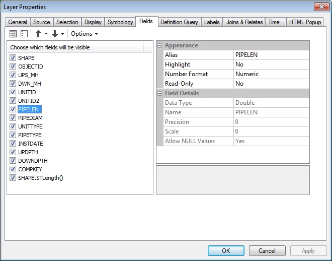
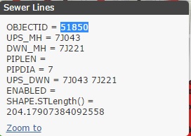
I stand corrected. When I choose display all field attributes they do not all display as can be seen in the screen capture. Both PIPELEN and PIPEDIA are both "double" data types.
- Mark as New
- Bookmark
- Subscribe
- Mute
- Subscribe to RSS Feed
- Permalink
Brad,
If you are just learning JS API then you should not be learning Legacy style coding (which is what you have right now). You need to be learning AMD Style coding. Here is a sample with your layers using AMD and I have simplified the info template text:
<!DOCTYPE html>
<html>
  <head>
    <meta http-equiv="Content-Type" content="text/html; charset=utf-8">
    <meta name="viewport" content="initial-scale=1, maximum-scale=1,user-scalable=no">


    <title>Info Window Lite</title>

    <link rel="stylesheet" href="https://js.arcgis.com/3.15/esri/css/esri.css">
    <style>
      html, body, #mapDiv { height: 100%; margin: 0; padding: 0; }
    </style>

    <script src="https://js.arcgis.com/3.15/"></script>
    <script>

      require([
        "esri/map",
        "esri/dijit/InfoWindow",
        "esri/InfoTemplate",
        "esri/layers/FeatureLayer",
        "dojo/dom-construct",
        "dojo/domReady!"
      ], function(
          Map,
          InfoWindow,
          InfoTemplate,
          FeatureLayer,
          domConstruct
         ) {

        var map = new Map("mapDiv", {
          basemap: "topo",
          center: [-92.315097, 34.733316],
          zoom: 16,
          basemap: "topo"
        });


        var infoWindow = new InfoWindow(null, domConstruct.create("div", null, null, map.root));
        infoWindow.startup();
        map.setInfoWindow(infoWindow);

        var template = new InfoTemplate();
        var tMH = "<b>${MH_NO}</b><br>Depth: ${MHDPTH}<br>Install Date: ${INSDATE}<br>Unit Type: ${UNITTYPE}<br>ServStat? ${SERVSTAT}";
        template.setTitle("Manholes");
        template.setContent(tMH);

        //add a layer to the map
        var lyrManholes = new FeatureLayer("http://app7:6080/arcgis/rest/services/MoreLayers/MapServer/0", {
          infoTemplate:template,
          outFields: ["*"]
        });
        map.addLayer(lyrManholes);

        var template2 = new InfoTemplate();
        var tSL = "<b>${UPS_MH} - ${DWN_MH}</b><br>Pipe Length: ${PIPELEN}";
        template2.setTitle("Sewer Lines");
        template2.setContent(tSL);

        //add a layer to the map
        var lyrSewers = new FeatureLayer("http://app7:6080/arcgis/rest/services/MoreLayers/MapServer/1", {
          infoTemplate:template2,
          outFields: ["*"]
        });
        map.addLayer(lyrSewers);

      });
    </script>
  </head>

  <body>
    <div id="mapDiv"></div>
  </body>

</html>
- Mark as New
- Bookmark
- Subscribe
- Mute
- Subscribe to RSS Feed
- Permalink
Yeah, I see that now. And the original problem isn't as broad as I thought. The attributes show up sometime. It may have something to do with my IDE. On to AMD.