- Home
- :
- All Communities
- :
- Developers
- :
- JavaScript Maps SDK
- :
- JavaScript Maps SDK Questions
- :
- Geolocation coordinates to Point geometry to use i...
- Subscribe to RSS Feed
- Mark Topic as New
- Mark Topic as Read
- Float this Topic for Current User
- Bookmark
- Subscribe
- Mute
- Printer Friendly Page
Geolocation coordinates to Point geometry to use in buffer
- Mark as New
- Bookmark
- Subscribe
- Mute
- Subscribe to RSS Feed
- Permalink
I am a bit new to JavaScript. I want to buffer the location of a person's position when they click the Locate Button Widget.
I modified the Locate Widget in the JavaScript API 4.0 a little bit. I am trying to get the coordinates of the position when you click the button, so that I can create a point geometry to use in a buffer. I have looked around and can't find a firm answer. I saw that you need to use the getCurrentPosition function, but some reason I can't properly implement it in my code. This is what I have so far:
<!DOCTYPE html>
<html>
<head>
<meta charset="utf-8">
<meta name="viewport" content="initial-scale=1,maximum-scale=1,user-scalable=no">
<title>Final Project</title>
<link rel="stylesheet" href="https://js.arcgis.com/4.1/esri/css/main.css">
<script src="https://js.arcgis.com/4.1/"></script>
<style>
html,
body,
#viewDiv {
padding: 0;
margin: 0;
height: 100%;
width: 100%;
}
#legendDiv {
max-width: 300px;
background-color: black;
padding: 8px;
color: white;
opacity: 0.85;
}
p {
max-width: 400px;
background-color: black;
padding: 15px;
border: 1px solid white;
color: white;
opacity: 0.95;
}
#toggle {
bottom: 20px;
left: 20px;
position: absolute;
z-index: 99;
max-width: 105px;
background-color: black;
border-radius: 8px;
padding: 10px;
color: white;
opacity: 0.85;
}
.esri-locate {
font-size: 18px;
background-color: white;
color: red;
width: 120px;
height: 40px;
padding: 0;
margin: 0;
border-radius: 8px;
overflow: hidden;
cursor: pointer;
}
.esri-locate span {
display: none;
}
.esri-locate:after {
content: 'GeoProcess';
}
</style>
<script>
require([
"esri/Map",
"esri/layers/FeatureLayer",
"esri/views/MapView",
"esri/widgets/Legend",
"esri/config",
"esri/core/urlUtils",
"esri/widgets/Locate",
"esri/layers/GraphicsLayer",
"esri/Graphic",
"esri/symbols/SimpleFillSymbol",
"esri/geometry/geometryEngine",
"dojo/dom-construct",
"dojo/dom",
"dojo/on",
"dojo/domReady!"
], function(
Map,
FeatureLayer,
MapView,
Legend,
esriConfig,
urlUtils,
Locate,
GraphicsLayer,
Graphic,
SimpleFillSymbol,
geometryEngine,
domConstruct,
dom,
on) {
var floodLayer = new FeatureLayer({
url: "https://igems.doi.gov/arcgis/rest/services/igems_haz/MapServer/0",
visible: true
});
var volcanoeLayer = new FeatureLayer({
url: "https://igems.doi.gov/arcgis/rest/services/igems_haz/MapServer/1",
visible: true
});
var earthquakeLayer = new FeatureLayer({
url: "https://igems.doi.gov/arcgis/rest/services/igems_haz/MapServer/3",
visible: true
});
var hurricaneLayer = new FeatureLayer({
url: "https://igems.doi.gov/arcgis/rest/services/igems_haz/MapServer/5",
visible: true
});
var wildfireLayer = new FeatureLayer({
url: "https://igems.doi.gov/arcgis/rest/services/igems_haz/MapServer/10",
visible: true
});
var shelterLayer = new FeatureLayer({
url: "http://gis.fema.gov/REST/services/NSS/FEMA_NSS/MapServer/5",
visible: false
});
var gLayer = new GraphicsLayer({});
var map = new Map({
basemap: "dark-gray",
layers: [gLayer, shelterLayer, floodLayer, volcanoeLayer, earthquakeLayer, hurricaneLayer, wildfireLayer]
});
var view = new MapView({
container: "viewDiv",
center: [-96.050173, 39.216911],
zoom: 5,
map: map
});
var legend = new Legend({
view: view,
layerInfos: [{
layer: floodLayer,
title: "Floods"
},
{
layer: volcanoeLayer,
title: "Volcanoes"
},
{
layer: earthquakeLayer,
title: "Earthquakes"
},
{
layer: hurricaneLayer,
title: "Hurricanes"
},
{
layer: wildfireLayer,
title: "Wildfires"
}]
}, "legendDiv");
view.ui.add(legend, "bottom-right");
var info = domConstruct.create("infoDiv", {
innerHTML: "<p>This map presents the geospatial locations for current natural hazards events (such as earthquakes, hurricanes, floods, and wildfires) as well as the locations of FEMA shelters. <br> <br> By clicking the button, this application will geocode your location, create a 5-10 mile buffer around that location, and provide directions to the closest shelter.</p>",
});
view.ui.add(info, "top-right");
var shelterTog = dom.byId("shelterToggle");
var wildfireTog = dom.byId("wildfireToggle");
var hurricaneTog = dom.byId("hurricaneToggle");
var earthquakeTog = dom.byId("earthquakeToggle");
var volcanoeTog = dom.byId("volcanoeToggle");
var floodTog = dom.byId("floodToggle");
on(shelterTog, "change", function(){
shelterLayer.visible = shelterTog.checked;
});
on(wildfireTog, "change", function(){
wildfireLayer.visible = wildfireTog.checked;
});
on(hurricaneTog, "change", function(){
hurricaneLayer.visible = hurricaneTog.checked;
});
on(earthquakeTog, "change", function(){
earthquakeLayer.visible = earthquakeTog.checked;
});
on(volcanoeTog, "change", function(){
volcanoeLayer.visible = volcanoeTog.checked;
});
on(floodTog, "change", function(){
floodLayer.visible = floodTog.checked;
});
//Locate Position
var locateBtn = new Locate({
view: view,
});
locateBtn.startup();
view.ui.add(locateBtn, {
position: "top-left",
index: 0
});
//Creat a symbol for buffer
var fillSymbol = new SimpleFillSymbol({
color: [227, 139, 79, 0.8],
outline: {color: [255, 255, 255],
width: 1
}
});
//Begin geoprocessing
locateBtn.on("locate", function(geoProcess){
view.zoom = 15;
navigator.geolocation.getCurrentPosition(function(position) {
var pt = new Point ({
longitude: position.coords.longitude,
latitude: position.coords.latitude
});
var buffer = geometryEngine.buffer(pt, 100, "miles");
var bufferGraphic = new Graphic({
geometry: buffer,
symbol: fillSymbol
});
gLayer.add(bufferGraphic);
});
});
});
</script>
</head>
<body>
<div id="viewDiv"></div>
<div id="legendDiv"></div>
<span id="toggle">
<input type="checkbox" id="shelterToggle"> Shelters<br>
<input type="checkbox" id="wildfireToggle" checked> Wildfires<br>
<input type="checkbox" id="hurricaneToggle" checked> Hurricanes<br>
<input type="checkbox" id="earthquakeToggle" checked> Earthquakes<br>
<input type="checkbox" id="volcanoeToggle" checked> Volcanoes<br>
<input type="checkbox" id="floodToggle" checked> Floods
</span>
</body>
</html>Solved! Go to Solution.
Accepted Solutions
- Mark as New
- Bookmark
- Subscribe
- Mute
- Subscribe to RSS Feed
- Permalink
Taylor,
In your locateBtn locate event handler just use:
Var locPnt = locateBtn.graphic.geometry;
- Mark as New
- Bookmark
- Subscribe
- Mute
- Subscribe to RSS Feed
- Permalink
If I am understanding you correctly, you could use this widget in WAB instead of writing your own code.
- Mark as New
- Bookmark
- Subscribe
- Mute
- Subscribe to RSS Feed
- Permalink
I appreciate your answer, but I need to write this in JavaScript without Web AppBuilder.
- Mark as New
- Bookmark
- Subscribe
- Mute
- Subscribe to RSS Feed
- Permalink
Taylor,
In your locateBtn locate event handler just use:
Var locPnt = locateBtn.graphic.geometry;
- Mark as New
- Bookmark
- Subscribe
- Mute
- Subscribe to RSS Feed
- Permalink
I added that text, and nothing happens with my buffer. It appears the point won't buffer at all. Is there maybe something wrong with my code for the buffer?
- Mark as New
- Bookmark
- Subscribe
- Mute
- Subscribe to RSS Feed
- Permalink
Taylor,
Did you use the new locPnt bar in the buffer?
- Mark as New
- Bookmark
- Subscribe
- Mute
- Subscribe to RSS Feed
- Permalink
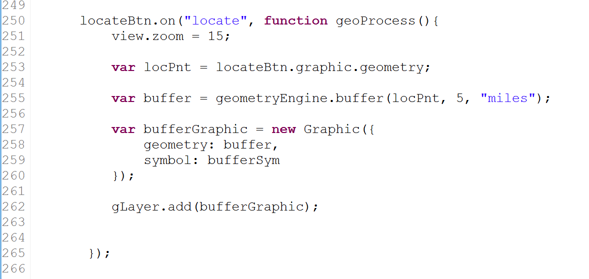
Yes, I did. See below:
- Mark as New
- Bookmark
- Subscribe
- Mute
- Subscribe to RSS Feed
- Permalink
Just checked the console and I am getting an error when I try to buffer:
"The input unit and the spatial reference unit are not of the same unit type.ie Linear vs.Angular"
Any ideas?
- Mark as New
- Bookmark
- Subscribe
- Mute
- Subscribe to RSS Feed
- Permalink
Ok so the likely issue is that the locate graphic is geographic and the map is web Mercator so you need to use webmercatorutils to project the point to web Mercator before you bugger it.
- Mark as New
- Bookmark
- Subscribe
- Mute
- Subscribe to RSS Feed
- Permalink
Stupid autocorrect that was buffer.