Turn on suggestions
Auto-suggest helps you quickly narrow down your search results by suggesting possible matches as you type.
Cancel
- Home
- :
- All Communities
- :
- Products
- :
- ArcGIS GeoStatistical Analyst
- :
- ArcGIS GeoStatistical Analyst Questions
- :
- Re: Automation of Kriging using model builder or p...
Options
- Subscribe to RSS Feed
- Mark Topic as New
- Mark Topic as Read
- Float this Topic for Current User
- Bookmark
- Subscribe
- Mute
- Printer Friendly Page
Problem with Geostatistical Analyst Tutorial GA Layers to pints
Subscribe
4622
4
07-19-2013 08:12 AM
07-19-2013
08:12 AM
- Mark as New
- Bookmark
- Subscribe
- Mute
- Subscribe to RSS Feed
- Permalink
Hi guys!!!!
Im doing the tutorial Geostatistical Analyst, in the exercise 1 after that kriging-cokriging in the step validation/prediction whith Default Kriging, i have aproblem whith the process, the result is the next: Dataset does not contain enough data to do calculations.
Thanks
Im doing the tutorial Geostatistical Analyst, in the exercise 1 after that kriging-cokriging in the step validation/prediction whith Default Kriging, i have aproblem whith the process, the result is the next: Dataset does not contain enough data to do calculations.
Thanks
4 Replies
07-19-2013
12:22 PM
- Mark as New
- Bookmark
- Subscribe
- Mute
- Subscribe to RSS Feed
- Permalink
I cannot reproduce this problem. Did you get this error when running GA Layer to Points geoprocessing tool?
07-19-2013
12:55 PM
- Mark as New
- Bookmark
- Subscribe
- Mute
- Subscribe to RSS Feed
- Permalink
Hi
I get Kriging/Cokriging using Geostatisitical Wizard then and i did validation/predicition
[ATTACH=CONFIG]26075[/ATTACH]
GA layers to points
[ATTACH=CONFIG]26076[/ATTACH]
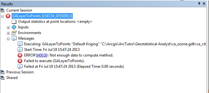
finally i get a error number 040039
[ATTACH=CONFIG]26077[/ATTACH]
Thanks!!!!
I get Kriging/Cokriging using Geostatisitical Wizard then and i did validation/predicition
[ATTACH=CONFIG]26075[/ATTACH]
GA layers to points
[ATTACH=CONFIG]26076[/ATTACH]
finally i get a error number 040039
[ATTACH=CONFIG]26077[/ATTACH]
Thanks!!!!
07-19-2013
01:06 PM
- Mark as New
- Bookmark
- Subscribe
- Mute
- Subscribe to RSS Feed
- Permalink
Ok, I see the problem. We have a known issue with using spaces in output feature class names. If you remove the spaces from the name of your shapefile, it should work.
Sorry for the inconvenience, and we're working on a fix for this problem.
Sorry for the inconvenience, and we're working on a fix for this problem.
09-11-2013
10:43 AM
- Mark as New
- Bookmark
- Subscribe
- Mute
- Subscribe to RSS Feed
- Permalink
I am using arcmap 10.2.
My project deals with the prediction of PM and Ozone concentrations for 2004-2006 (1098 days) using known concentrations of them at
99 grids throughout the county.
I am trying to predict the unknown concentrations at mother's residences using ordinary kriging.
This is what I am doing:
1. Use Geostatistical Wizard
2. Select kriging cokriging
3. Input the Data layers and specifications
4. Select Finish
5. Read the model parameters and click OK
6. Generate Kriged predictions
7. Right click on Kriged data and convert to raster
8. Use spatial analyst tool Extraction
9. Select "Extract values to points"
10. Generate Extracted values of kriged predictions
11. Select conversion tool
12. Choose convert From Raster to Ascii
13. Generate the Ascii table.
14. Alternatively use Sample tool and input multiple rasters to generate an output table.
My question:
1. I need some guidance for automating this kriging process using model builder or python?
2. Is there any way to directly copy and paste the raster values to excel?
Can any one provide me a lead into this