- Home
- :
- All Communities
- :
- Products
- :
- ArcGIS GeoEvent Server
- :
- ArcGIS GeoEvent Server Questions
- :
- Re: GIS/Scada Integration
- Subscribe to RSS Feed
- Mark Topic as New
- Mark Topic as Read
- Float this Topic for Current User
- Bookmark
- Subscribe
- Mute
- Printer Friendly Page
- Mark as New
- Bookmark
- Subscribe
- Mute
- Subscribe to RSS Feed
- Permalink
Hello I want to integrate my GIS and SCADA System.Has anybody done this? How can i do it with Geoevent Processor and is there any SCADA sensor connetor for Geoevent Processor?
Thanks For Helping
Solved! Go to Solution.
Accepted Solutions
- Mark as New
- Bookmark
- Subscribe
- Mute
- Subscribe to RSS Feed
- Permalink
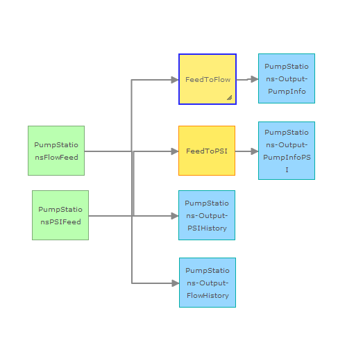
As part of the ArcGIS for Utilities Solution, I just spotted a Water SCADA Processor solution.
This also appears under the Local Government Solution as well.
This solutions provides:
- Map services for pumps, tanks, flow meters, daily tank changes and daily flow summary
- Limited view into historical data
- Real time calculations
- Mark as New
- Bookmark
- Subscribe
- Mute
- Subscribe to RSS Feed
- Permalink
OSISoft is working on their PI Connector to bring in both real-time and data from Historian into ArcGIS. The real-time part will be streaming via WebSocket or the new Stream Service in ArcGIS Server. I am working with a utility district in Tennessee to bring in SCADA data from Wonderware into GEP.
- Mark as New
- Bookmark
- Subscribe
- Mute
- Subscribe to RSS Feed
- Permalink
As part of the ArcGIS for Utilities Solution, I just spotted a Water SCADA Processor solution.
This also appears under the Local Government Solution as well.
This solutions provides:
- Map services for pumps, tanks, flow meters, daily tank changes and daily flow summary
- Limited view into historical data
- Real time calculations
- Mark as New
- Bookmark
- Subscribe
- Mute
- Subscribe to RSS Feed
- Permalink
Simon Thank you!
I'll try this solution.Thanks for helping.