- Home
- :
- All Communities
- :
- Products
- :
- ArcGIS Field Maps
- :
- ArcGIS Field Maps Questions
- :
- Field maps and Trimble DA2 catalyst
- Subscribe to RSS Feed
- Mark Topic as New
- Mark Topic as Read
- Float this Topic for Current User
- Bookmark
- Subscribe
- Mute
- Printer Friendly Page
Field maps and Trimble DA2 catalyst
- Mark as New
- Bookmark
- Subscribe
- Mute
- Subscribe to RSS Feed
- Permalink
- Mark as New
- Bookmark
- Subscribe
- Mute
- Subscribe to RSS Feed
- Permalink
Best practice with devices like Catalyst is to crosscheck with few control points before starting work. Catalyst probably works on ITRF Current Epoch which will not match with your local reference. Trimble offers several output CRS options but you should make sure that the correct positions are passed to Esri from here. I am assuming that you see close to 30cm accuracy while working but this is not stored in GNSS metadata fields in the layer. Is this the case?
- Mark as New
- Bookmark
- Subscribe
- Mute
- Subscribe to RSS Feed
- Permalink
Thanks Chau, yes cross checking with a few control points is a great idea. Hindsight is a beautiful thing! Will definitely do this next week for the next survey. Yes there are several different CRS options and I think I overlooked this when setting up the new Catalyst as it had already been done on the previous one I was using.
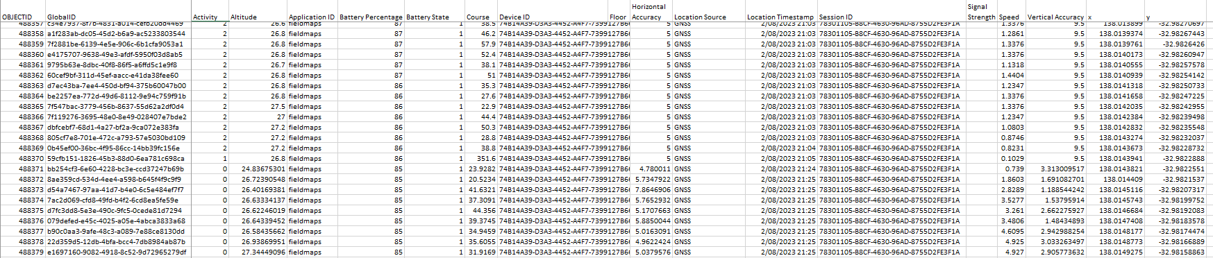
I have taken a snip from the output from the Catalyst which has been generated when I upload the data collected in Field Maps to ArcGIS online. Whilst I see the reported GPS accuracy in the top bar of Field Maps in the data file the values don't seem to be correct. ie they are metres instead of cm. I would be expecting less than 50 cm with the 30 cm subscription service that I was using and where I was conducting the survey. So I am not entirely sure what these accuracy columns refer to (image below and attached)?

thanks for your assistance.
- Mark as New
- Bookmark
- Subscribe
- Mute
- Subscribe to RSS Feed
- Permalink
Have you had any luck with this? I have a similar bust. Could it be the ITRF2014 to Auxiliary Sphere?
- Mark as New
- Bookmark
- Subscribe
- Mute
- Subscribe to RSS Feed
- Permalink
@EddieWBanks From the names of the fields, these do not look like standard Esri GNSS metadata fields. How did you get these fields? Standard Esri fields should look like below.

What is the value in "Fix Type" field for you? I want to know if the smartphone was receiving corrections via Catalyst or just using the internal autonomous GNSS. The accuracy values look more like the phone GNSS. That could also explain the shift from local control points.
Sincerely
- Mark as New
- Bookmark
- Subscribe
- Mute
- Subscribe to RSS Feed
- Permalink
Hi Y Chau,
Yes I just used the default settings that were provided. I see that if I go to the desktop version of Field Maps I can adjust some of these settings in the table. To me it is not clear though how Field Maps on the device is pulling the data from the Catalyst?
I have used both IOS and Android devices and the fix type seems to mostly 'fused'. However, sometimes you see that the vertical accuracy is better than the horizontal which shouldnt be the case. Also this was using the 10cm subscription service. I understand it takes some time to lock in but this is an area with plenty of 4G/5G phone coverage.
Whether this is because I have been setting the collection settings to 1 sec. Although the table shows that data is not collected at this frequency generally several seconds.
If you have any suggestions that would be great
Thanks
Eddie

- Mark as New
- Bookmark
- Subscribe
- Mute
- Subscribe to RSS Feed
- Permalink
Hi Matthew,
No not much success on this yet. I have now set the dataframe in Trimble mobile manager to ITRF2014, Geoid to EGM96 (Global) and making sure field maps is also using WGS84.
I just collected some new data last week and the downloaded data file from Field Maps shows vertical accuracies are greater than horizontal? WTF? So still not sure what and how Field Maps is capturing the data from the Catalyst.
In the top window of Field Maps while collecting data it reports the GPS accuracy, which seems to be that of the Catalyst subscription but looking at the data file it is very different.
I also require that my gps positions are collected every second, which it allows me to do so in the setup menu but it only reports the data every 2-3 seconds in the data table????. I realise that the accuracy might not be as good whilst walking along but my other gps has no issue in sending high frequency data.
If you have any suggestions that would be great on how to resolve the issue that would be awesome.