- Home
- :
- All Communities
- :
- Products
- :
- ArcGIS Field Maps
- :
- ArcGIS Field Maps Questions
- :
- Collect one point per second
- Subscribe to RSS Feed
- Mark Topic as New
- Mark Topic as Read
- Float this Topic for Current User
- Bookmark
- Subscribe
- Mute
- Printer Friendly Page
Collect one point per second
- Mark as New
- Bookmark
- Subscribe
- Mute
- Subscribe to RSS Feed
- Permalink
I need to develop a workflow where a user collects one point per second as they meander along a path. The reason I need points as opposed to lines is because I need the time recorded with every point so that I can join the data (via timestamp) with data from another device. It would also be nice to have the GPS metadata recorded for each point too so we can evaluate it for poor accuracy. The only workflow I can envisage is to stream a line with the relevant stream settings, then post-processing afterwards (feature vertices to points). Then somehow assigning the time based on the time recorded with the line. Though I haven't actually looked in how to do that yet and could imagine there might be time issues between the device and the time assigned to the line. This would also lack GPS metadata (but that's not essential).
Does anybody have any ideas on workflows to achieve this?
- Mark as New
- Bookmark
- Subscribe
- Mute
- Subscribe to RSS Feed
- Permalink
This is like survey kind of data collection. Indeed it will be useful to have in Field Maps.
Sincerely
- Mark as New
- Bookmark
- Subscribe
- Mute
- Subscribe to RSS Feed
- Permalink
Time recorded GPS and video / other devices is well documented in many websites that collect pathways for fun. professional data collectors also do this from what I read. 1 second GPS recording is already setup in Field maps. Are you asking how to join it to your other device?
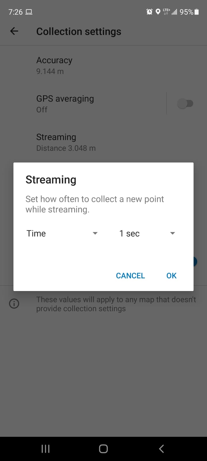
go into the app before you enter a map, under your profile picture select settings > Collection Settings > Streaming. I believe this will complete your Field Maps requirements.
- Mark as New
- Bookmark
- Subscribe
- Mute
- Subscribe to RSS Feed
- Permalink
Thanks for the response. I am aware of the collection settings in Field Maps, but this applies to the vertices of a line with the result being one line feature with vertices collected at 1 second intervals. I need the points collected at 1 point per second so each has a time stamp and can be joined to aspatial data that is collected at the same time.
As the vertices are collected at 1 point per second, I could do a post-processing workflow where I use the feature vertices to points tool, but then to apply the timestamp I would have to calculate it for each point based on something like the creation date which I feel might have some error (e.g. if it takes a few seconds to sync with the server upon submission, the data will be out be a few seconds).
- Mark as New
- Bookmark
- Subscribe
- Mute
- Subscribe to RSS Feed
- Permalink
I might have to see the data but I'm sure the Vertex should have the normal GPS data stored with it including GPS Sat Time stamp. Mobile Mapping systems, and most GPS will store location and Time as time is one of the key foundations of GPS. Maybe one of the experts in field maps can confirm.
If you are using the phone or device field maps runs on the time trigger should be close and if you use an upgraded GPS unit or better yet a multi-device trigger system that pushes a single time to each device per trigger event (second) you wouldn't have a problem.
Depending on your need for accuracy, cellphone / second is pretty good for most data collection. If you need better than about 3-5 meters you should consider higher accuracy GPS
For Sub meter & Sub second requirements I wouldn't count on a cell phone alone... EOS has some cool video's on accurate data collection with their Arrow I would consider for an upgrade. Esri has so many partners that are skilled in improving the basic's from just a cell phone.
Last , just double check you are asking to store the GPS time in your table for a simply way to join it to the other devices data.
- Mark as New
- Bookmark
- Subscribe
- Mute
- Subscribe to RSS Feed
- Permalink
Unfortunately that's the problem. The vertices of a line do not save the GPS metadata. Only points do. And it isn't possible to stream points.
And you predicted it correctly, we are using an EOS Arrow Gold for location data collection. We also have another device (not related to location) that is also collecting data.
And yes, I am trying to join the data from the other device to the data collected by the Arrow based on time.
- Mark as New
- Bookmark
- Subscribe
- Mute
- Subscribe to RSS Feed
- Permalink
Would using the Location Tracking capability in ArcGIS Field Maps (formerly ArcGIS Tracker app) work for your workflow? I understand that the location tracking layer is stored as points but visualized as a a line.
Track location with Field Maps (esri.com)
Best regards,
Kanin
If this answer solved your question, please mark it as "Accept as Solution" to help others who have the same question.
- Mark as New
- Bookmark
- Subscribe
- Mute
- Subscribe to RSS Feed
- Permalink
Thanks for the response. It would work well except:
- I don't think the recording frequency goes as low as 1 point per second,
- Last I checked, to save battery, if the operator doesn't move it doesn't record points which would throw off the time sync in our case,
- Ideally (but not essentially) it would record the attributes we were collecting.
- Mark as New
- Bookmark
- Subscribe
- Mute
- Subscribe to RSS Feed
- Permalink
Were you able to come up with a solution for this? I'm trying to do the very same thing.
- Mark as New
- Bookmark
- Subscribe
- Mute
- Subscribe to RSS Feed
- Permalink
Sorry. Unfortunately not. The recommendation to use tracker is a reasonable one, but as I mentioned in my reply, the point frequency isn't great enough to sync to my other device data. Nevertheless, recording one point per 60 seconds would help, but still make post-processing a bit difficult.