- Home
- :
- All Communities
- :
- Products
- :
- ArcGIS Field Maps
- :
- ArcGIS Field Maps Questions
- :
- Clustering Symbology Not Available in Field Maps M...
- Subscribe to RSS Feed
- Mark Topic as New
- Mark Topic as Read
- Float this Topic for Current User
- Bookmark
- Subscribe
- Mute
- Printer Friendly Page
Clustering Symbology Not Available in Field Maps Mobile App?
- Mark as New
- Bookmark
- Subscribe
- Mute
- Subscribe to RSS Feed
- Permalink
Hello -
I've recently begun experimenting with designing maps and forms in the dedicated Field Maps web platform.
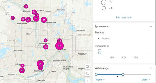
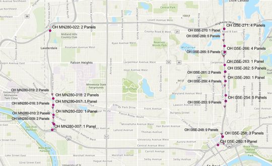
I'm customizing a map (using the new web viewer, not classic) with a single set of data that I've duplicated three times: once to symbolize all the layer's features with clustering when zoomed out to a city view (see below) and beyond, and then twice more (with different symbol shapes to account for two different collection priority levels) with individual feature symbols for viewing while zoomed in.
(clustering at small scales)
(individual features at larger scales)
All three layers symbolize properly in the new map viewer (both in AGOL proper and via the Field Maps web app interface), but when I open the map in the Field Maps mobile app, the version of the layer that's meant to appear as clustered instead symbolizes each individual feature (see below).
Is it a known limitation that Field Maps Mobile can't display clustered symbology yet? I know that's the default for Survey123's map interface, so I wanted to make sure. I know it is the smaller-scale layer that's still appearing while zoomed out, because that layer has different per-feature labels than the two larger-scale layers.
Thanks!
Galen S.
MnDOT
- Mark as New
- Bookmark
- Subscribe
- Mute
- Subscribe to RSS Feed
- Permalink
+1
Yes, I am also interested in this functionality. Is it supported in Field Maps or on the roadmap?
- Mark as New
- Bookmark
- Subscribe
- Mute
- Subscribe to RSS Feed
- Permalink
Yes, that would be great!


