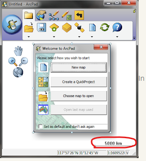
When doing locates in field maps with a R2 or a Catalyst antenna, it would be nice to have the zoom scale dynamically displayed. This is a good reference point for using the GPS unit for locating objects such as a waterline. Without a scale you have no refence to tell if your in tight enough or not. This is a feature on ARCPAD which is what we are migrating from, and it would make the field staffs transition a lot easier, as ARCPAD already can display the scale.