- Home
- :
- All Communities
- :
- Products
- :
- ArcGIS Explorer
- :
- ArcGIS Explorer Questions
- :
- Re: ArcGIS Explorer for iPhone support attachments...
- Subscribe to RSS Feed
- Mark Topic as New
- Mark Topic as Read
- Float this Topic for Current User
- Bookmark
- Subscribe
- Mute
- Printer Friendly Page
ArcGIS Explorer for iPhone support attachments?
- Mark as New
- Bookmark
- Subscribe
- Mute
- Subscribe to RSS Feed
- Permalink
Can anyone tell me if ArcGIS Explorer for iPhone supports attachments from an enterprize Db shared to ArcGIS Online? I can see them from the AGO viewer but not from Explorer.
Solved! Go to Solution.
- Mark as New
- Bookmark
- Subscribe
- Mute
- Subscribe to RSS Feed
- Permalink
Build your webmap using that URL.
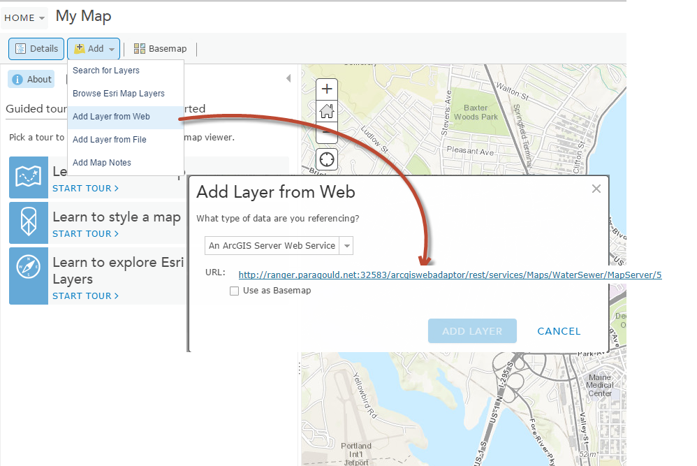
Configure the popup, save the map, and see if the Attachments are listed in the popup.
Mark
- Mark as New
- Bookmark
- Subscribe
- Mute
- Subscribe to RSS Feed
- Permalink
BINGO!! That did it.
Will I need to add a layer separately in my AGO map for each layer that has attachments? Currently I have all my water and sewer layers in one WaterSewer.mxd and each utility is in its own group...so nice and tidy. If I have to do this separately, is there a way to group the layers together in AGO as I did in the mxd file?
Lane
- Mark as New
- Bookmark
- Subscribe
- Mute
- Subscribe to RSS Feed
- Permalink
Lane,
That is wild !!! I just finished doing the same and it does work. The question does remain about having "datasets" or "groups" ? We only have one layer with attachments and adding another map service doesn't seem to affect the performance of the app so far.
We are a natural gas distribution company and we have attached PDF's to about 80% of our meter location point features (we have approx. 14,000 service locations).
We are also working with our county water department and have started mapping some of their assets. We are doing that randomly and we don't have a clue about water data models, but I have tried to study a little about water.
Thanks, JeffJ
- Mark as New
- Bookmark
- Subscribe
- Mute
- Subscribe to RSS Feed
- Permalink
Jeff,
This may be a good resource for you. http://downloads2.esri.com/support/TechArticles/Water_Utilities_Data_Model.pdf
Lane H.
GIS Coord.
PLWC, Paragould, AR
870-239-7721
- Mark as New
- Bookmark
- Subscribe
- Mute
- Subscribe to RSS Feed
- Permalink
Hi Heather,
Is this something that will be fixed in a future release?
- Mark as New
- Bookmark
- Subscribe
- Mute
- Subscribe to RSS Feed
- Permalink
Lane,
Same issue with us. Published map service from 10.2.1 enterprise server and no attachment links visible in Explorer (iPad). I understand Mark and Heather about the full REST URL to the layer, but we are publishing from a dataset in the MXD and I'm not sure we want to break those features apart and publish a ton of different services. Our attachments work fine with the AGO viewer and the old ArcGIS app. Seems like it might be a bug.
JeffJ
- Mark as New
- Bookmark
- Subscribe
- Mute
- Subscribe to RSS Feed
- Permalink
Jeff Johnson wrote:
...but we are publishing from a dataset in the MXD and I'm not sure we want to break those features apart and publish a ton of different services. Our attachments work fine with the AGO viewer and the old ArcGIS app. Seems like it might be a bug.
We're doing the same thing Jeff.
- Mark as New
- Bookmark
- Subscribe
- Mute
- Subscribe to RSS Feed
- Permalink
Lane and Jeff,
You don't have to re-publish your services. It just a matter of building your web map differently from the services you already published.
As Heather wrote when using the rest URL make sure you include the layer number.
Mark
- Mark as New
- Bookmark
- Subscribe
- Mute
- Subscribe to RSS Feed
- Permalink
hi
I have attachments that are PDFs and they show up in explorer but the ones that are .TIFS do not.
I am working on an iPad, is there any reason they wouldn't at least show up in the list.
also
I too just added the REST service for the entire mapservice, not each individual layer.
this is what I did for the layer that is displaying the PDF attachments.
- Mark as New
- Bookmark
- Subscribe
- Mute
- Subscribe to RSS Feed
- Permalink
update
I just added the layer again to the webmap using the complete rest url with the number at the end
and the TIF attachment now shows up.
issues-- all the labeling and symbology that I had set in the MXD are gone and I have to use the POOR choices in the webmap. I don't even see the labels that I supposedly configured.
so
why do I see attachments for one layer and not the others, like the one I just tested? it is the first one in the list of layers.
is there any ESRI documentation regarding the need to add the layer with the full URL?