Turn on suggestions
Auto-suggest helps you quickly narrow down your search results by suggesting possible matches as you type.
Cancel
- Home
- :
- All Communities
- :
- Products
- :
- ArcGIS Explorer Desktop (Retired)
- :
- ArcGIS Explorer Desktop Questions
- :
- Layer file info
Options
- Subscribe to RSS Feed
- Mark Topic as New
- Mark Topic as Read
- Float this Topic for Current User
- Bookmark
- Subscribe
- Mute
- Printer Friendly Page
Layer file info
Subscribe
846
0
11-30-2012 08:25 AM
11-30-2012
08:25 AM
- Mark as New
- Bookmark
- Subscribe
- Mute
- Subscribe to RSS Feed
- Permalink
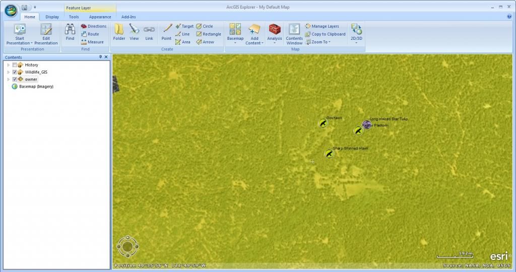
So I created a layer file in ArcGIS so that my co-workers can open the layerfile in ArcGIS Explorer. It is a wildlife database with various attributes. Which one "Category" is a subtype using coded values so 1= Mammal 2= bird 3= Amphibian 4= etc. etc. then under the subtype I have species using a domain with coded values. so underneath the mammals subtype I have species 1= Black Bear 2= Sierra Nevada Red Fox 3= Fisher 4 = Etc. etc.
After my cowworkers open the new layer file which is symbolised by category. They can click on each point which is labeled
when they click on one of the points this image appears
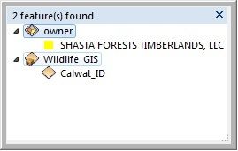 Wildlife_GIS is the file Im interested in, below it it labels it as CalWat_ID (Which is actually a field name) It would be cool if someone could teach me how to label using one of the attributes.
Lastly, When I click on CalWat_ID to display the attributes it gives me this image of the attributes within the point
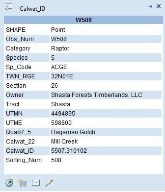 It labels the top as Calwat_Id (again I would like it to say Wildlife_GIS which is the name of the layer file).
Then in Bold it says W508 which is fine but why does it doe this? Could I change it to say The category? Which is Raptor?
Also to the right I Species it puts "5" which was a coded value in ArcGIS but does not recognize 5 =Goshawk.
Any help is greatly appreciated. Thanks
Blaine
PS I did search the forums and came up empty. Thanks
After my cowworkers open the new layer file which is symbolised by category. They can click on each point which is labeled
when they click on one of the points this image appears
Wildlife_GIS is the file Im interested in, below it it labels it as CalWat_ID (Which is actually a field name) It would be cool if someone could teach me how to label using one of the attributes. Lastly, When I click on CalWat_ID to display the attributes it gives me this image of the attributes within the point
It labels the top as Calwat_Id (again I would like it to say Wildlife_GIS which is the name of the layer file).Then in Bold it says W508 which is fine but why does it doe this? Could I change it to say The category? Which is Raptor?
Also to the right I Species it puts "5" which was a coded value in ArcGIS but does not recognize 5 =Goshawk.
Any help is greatly appreciated. Thanks
Blaine
PS I did search the forums and came up empty. Thanks
0 Replies