Turn on suggestions
Auto-suggest helps you quickly narrow down your search results by suggesting possible matches as you type.
Cancel
- Home
- :
- All Communities
- :
- Products
- :
- ArcGIS Explorer Desktop (Retired)
- :
- ArcGIS Explorer Desktop Questions
- :
- Re: Interactive geotagging doesn't place photo at ...
Options
- Subscribe to RSS Feed
- Mark Topic as New
- Mark Topic as Read
- Float this Topic for Current User
- Bookmark
- Subscribe
- Mute
- Printer Friendly Page
Interactive geotagging doesn't place photo at clicked point
Subscribe
1364
11
07-03-2011 03:19 AM
07-03-2011
03:19 AM
- Mark as New
- Bookmark
- Subscribe
- Mute
- Subscribe to RSS Feed
- Permalink
- Report Inappropriate Content
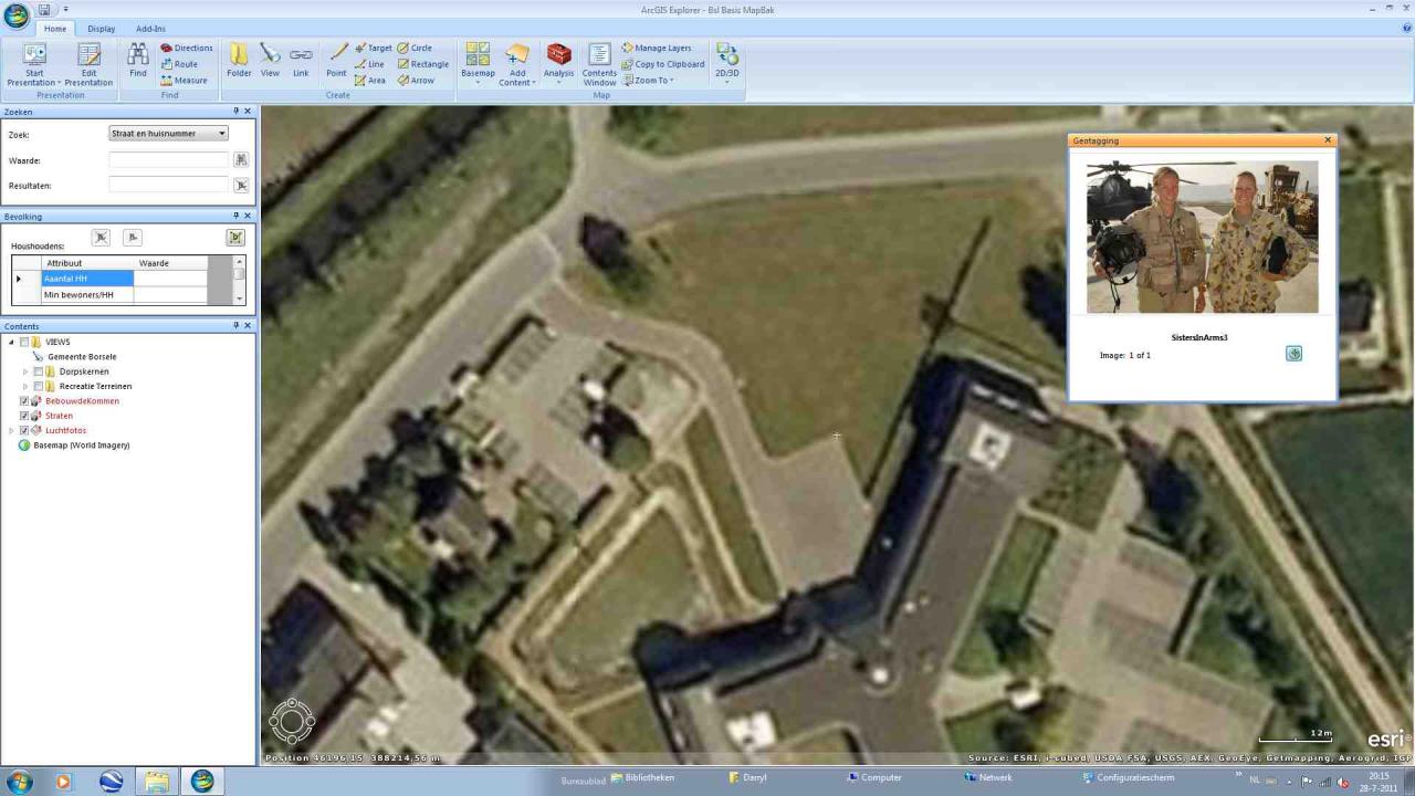
We have found that when interactively placing non-geotagged photos that Explorer places the point about 95 meters south of the clicked point. Is there some way to fix this problem?
We use a 2D coordinate system with the RD_New projection for the Netherlands. There is an attachment with our .nmf in the thread I started about notes not being available for point layers in spatial selection. If you folks would like a new attachment for testing, just let me know ....
We use a 2D coordinate system with the RD_New projection for the Netherlands. There is an attachment with our .nmf in the thread I started about notes not being available for point layers in spatial selection. If you folks would like a new attachment for testing, just let me know ....
11 Replies
07-04-2011
10:22 AM
- Mark as New
- Bookmark
- Subscribe
- Mute
- Subscribe to RSS Feed
- Permalink
- Report Inappropriate Content
Darryl, thanks for reporting the issue. We will take a look at it.
07-05-2011
07:45 AM
- Mark as New
- Bookmark
- Subscribe
- Mute
- Subscribe to RSS Feed
- Permalink
- Report Inappropriate Content
According to my (geographic) calculations, you were working on 4th July when you replied, Andriy.
Thanks and look forward to hearing the results, and hopefully a solution.
Thanks and look forward to hearing the results, and hopefully a solution.
07-08-2011
07:21 AM
- Mark as New
- Bookmark
- Subscribe
- Mute
- Subscribe to RSS Feed
- Permalink
- Report Inappropriate Content
aivanov
Darryl, thanks for reporting the issue. We will take a look at it.
Have the folks at ESRI made any headway with this yet?
07-27-2011
03:56 AM
- Mark as New
- Bookmark
- Subscribe
- Mute
- Subscribe to RSS Feed
- Permalink
- Report Inappropriate Content
It's been more than 3 weeks since this was posted. The guys at ESRI were going to look into it.
Will ESRI kindly break radio silence and let me know if there are any developments?
Will ESRI kindly break radio silence and let me know if there are any developments?
07-27-2011
09:31 AM
- Mark as New
- Bookmark
- Subscribe
- Mute
- Subscribe to RSS Feed
- Permalink
- Report Inappropriate Content
08-01-2011
12:18 AM
- Mark as New
- Bookmark
- Subscribe
- Mute
- Subscribe to RSS Feed
- Permalink
- Report Inappropriate Content
Andrij,
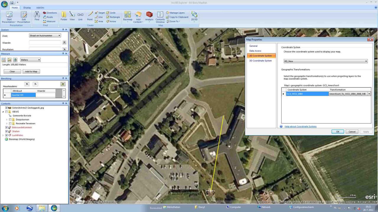
It seems to depend on which computer we use. Enclosed are screenshots of geotagging on computer 1 and geotagging on computer 2. Both have the same 2D coordinate system. Screenshot 2A shows the setting on computer 2. I was unable to load the 6th screenshot (1A) which proves this. Apparently the limit is 5 uploads. If you want, I can send a second post with that 1 screenshot.
Any idea why it works on one computer and not on the other?
08-01-2011
10:35 AM
- Mark as New
- Bookmark
- Subscribe
- Mute
- Subscribe to RSS Feed
- Permalink
- Report Inappropriate Content
Darryl,
I took a look at this, and found that I could not reproduce the problem if I set the map coordinate system to RD_New.. similar to what Andrei reported. However, If I set a transformation (Amersfoort to wgs 1984), I do see the photograph placed, away from where I clicked.
To explain the difference between your two computers, it may be a difference of the map and specifically whether a transformation is being used or not.
Mark
08-01-2011
11:30 AM
- Mark as New
- Bookmark
- Subscribe
- Mute
- Subscribe to RSS Feed
- Permalink
- Report Inappropriate Content
Mark,
Thanks for looking at our problem.
The coordinate system for each map on both computers is the same and all content on both (except for the basemap ESRI World Imagery) is in RD_New.
Can you advise me how to go about looking for where the difference might be lurking?
Thanks for looking at our problem.
The coordinate system for each map on both computers is the same and all content on both (except for the basemap ESRI World Imagery) is in RD_New.
Can you advise me how to go about looking for where the difference might be lurking?
08-03-2011
10:40 AM
- Mark as New
- Bookmark
- Subscribe
- Mute
- Subscribe to RSS Feed
- Permalink
- Report Inappropriate Content
I notice in one of the screen shots that you sent that the transformation had been set, and that is what I did to reproduce the problem. When the transformation is set to "none" the photo is geotagged at the clicked location.
http://forums.arcgis.com/attachment.php?attachmentid=8014&d=1312186167
http://forums.arcgis.com/attachment.php?attachmentid=8014&d=1312186167