Turn on suggestions
Auto-suggest helps you quickly narrow down your search results by suggesting possible matches as you type.
Cancel
- Home
- :
- All Communities
- :
- Products
- :
- ArcGIS Explorer Desktop (Retired)
- :
- ArcGIS Explorer Desktop Questions
- :
- Feature location problem in KMZ files
Options
- Subscribe to RSS Feed
- Mark Topic as New
- Mark Topic as Read
- Float this Topic for Current User
- Bookmark
- Subscribe
- Mute
- Printer Friendly Page
Feature location problem in KMZ files
Subscribe
2373
2
08-11-2010 04:58 AM
08-11-2010
04:58 AM
- Mark as New
- Bookmark
- Subscribe
- Mute
- Subscribe to RSS Feed
- Permalink
When converting data from ArcMap to a KMZ for use in AGX, I'm noticing that all the features are shifted from their true location by several feet. Also, when I add point graphics or run the Buffer Feature analysis tool that is included with AGX 1200, they also shift off the point where I actually clicked.
Has anyone else experienced this? Maybe I have a problem in my coordinate system settings?
Has anyone else experienced this? Maybe I have a problem in my coordinate system settings?
2 Replies
08-11-2010
11:52 PM
- Mark as New
- Bookmark
- Subscribe
- Mute
- Subscribe to RSS Feed
- Permalink
Nicholas,
The ArcMap > KML/KMZ shift sounds like it could be a projection issue between the coordinate system you are using in ArcMap, perhaps any transformation you have set for the data frame and the client application (presumed to be ArcGIS Explorer based on the forum), it's coordinate system and again any transformations that are active.
However, the Buffer tool click point shift sounds odd - it should capture the point exactly where you click. My guess here would be some issue between capturing the screen click point and converting it to real world coordinates. Perhaps a screen/dpi issue?
Regards
Mike
08-12-2010
04:10 AM
- Mark as New
- Bookmark
- Subscribe
- Mute
- Subscribe to RSS Feed
- Permalink
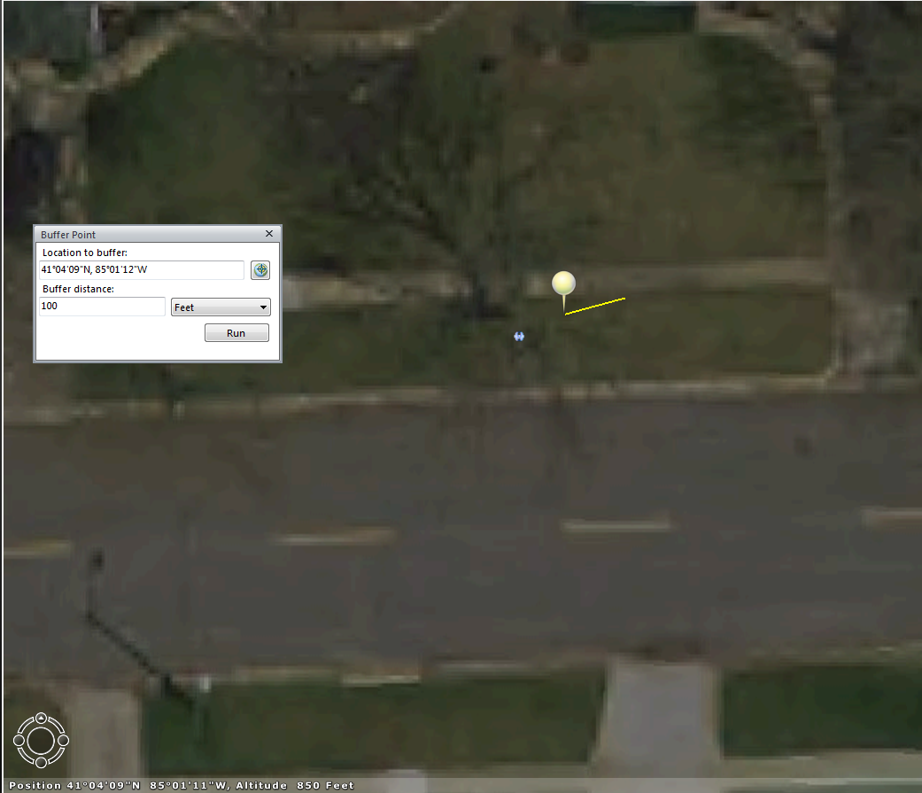
Attached are some screenshots showing the "shifts" I'm seeing. "Buffer_Shift_1.PNG" and "Buffer_Shift_2.PNG" show the before and after of the buffer tool. I placed the buffer point directly on top of the blue symbol, but it displayed several feet off. And then, after clicking "Run" on the Buffer Point window, the pin symbol jumped way over to the west.
"KMZ_Shift.PNG" shows the difference between the same layer when it is displayed as a layer package vs. a KML. The blue point on the left is KML and the one on the right is LPK. The yellow line is a measurement I took, which you can also see didn't display where I actually clicked.
"Transformation.PNG" is just a screenshot of the 3D coordinate system settings. I've also noticed that these settings aren't being saved across Explorer sessions, I have to keep resetting them.
Here is the coordinate system properties of the data frame containing the layers the the KML/KMZ was created from:
NAD_1983_StatePlane_Indiana_East_FIPS_1301_Feet
Projection: Transverse_Mercator
And the coordinate system in the layer properties (in ArcMap):
Projected Coordinate System: NAD_1983_StatePlane_Indiana_East_FIPS_1301_Feet
Projection: Transverse_Mercator
Here is what is listed in the Map Properties of Explorer:
Coordinate System: GCS_North_American_1983, Transformation: NAD_1983_To_WGS_1984_5
And in the layer properties in Explorer for the layer package (the KML doesn't have a coordinate system listed under it's layer properties):
Coordinate System: NAD_1983_StatePlane_Indiana_East_FIPS_1301_Feet