Turn on suggestions
Auto-suggest helps you quickly narrow down your search results by suggesting possible matches as you type.
Cancel
- Home
- :
- All Communities
- :
- Products
- :
- ArcGIS Enterprise
- :
- ArcGIS Enterprise Questions
- :
- PrintingTools omits referenced map symbols
Options
- Subscribe to RSS Feed
- Mark Topic as New
- Mark Topic as Read
- Float this Topic for Current User
- Bookmark
- Subscribe
- Mute
- Printer Friendly Page
PrintingTools omits referenced map symbols
Subscribe
1742
0
03-10-2016 01:56 AM
03-10-2016
01:56 AM
- Mark as New
- Bookmark
- Subscribe
- Mute
- Subscribe to RSS Feed
- Permalink
I've implemented PrintingTools in my JavaScript application to offer users the capability to export a map to a PNG file. It worked quite well for months. But suddenly, exported maps don't show map symbols anymore. Instead, the only thing visible is the default symbol delivered by my ArcGIS service.
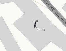
This is how it is supposed to be and how looks like in my app:
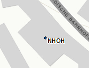
And this is what I get in the png file:
Background info:
- The symbol files (PNG) are stored on a different web server, not on the ArcGIS server machine.
- References to the symbol files are set with JavaScript, overriding the default symbol delivered by the map service.
- The symbol files location is accessible without restrictions for user's clients. This is obvious, because the app is working on the clients (except exporting, though). Also, I'm able to see the symbol if I navigate to the symbol file URL in a browser.
- The symbol files location is also accessible without restrictions from our ArcGIS server machine. This is required to make PrintingTools work. To test whether they are accessible, I navigate to the symbol file URL in a browser and can see the symbol. So: Port is open.
But despite the symbols seem to be accessible, the symbol is omitted when exporting.
I've looked at PrintingTools logs, but this error seems not to be logged. The file is just ignored.
Any ideas or hints where to search next?
Regards
Tobias
0 Replies