- Home
- :
- All Communities
- :
- Products
- :
- ArcGIS Enterprise
- :
- ArcGIS Enterprise Questions
- :
- PrintingTools (GP server) Export Web Map Task - Sc...
- Subscribe to RSS Feed
- Mark Topic as New
- Mark Topic as Read
- Float this Topic for Current User
- Bookmark
- Subscribe
- Mute
- Printer Friendly Page
PrintingTools (GP server) Export Web Map Task - Scaling Issues?
- Mark as New
- Bookmark
- Subscribe
- Mute
- Subscribe to RSS Feed
- Permalink
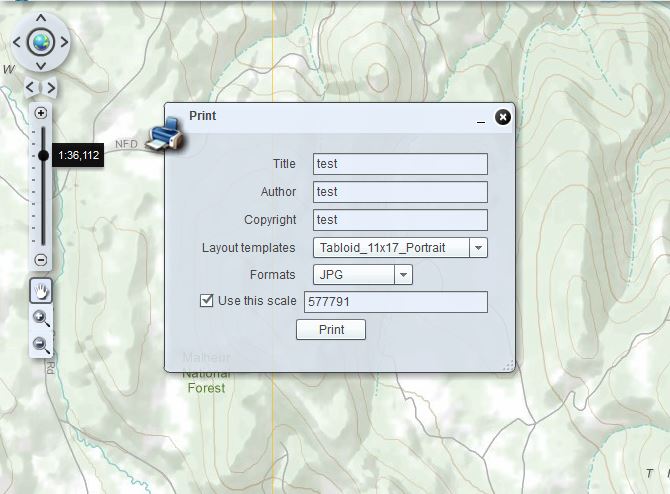
When printing, if the user does not check ???use this scale??? box in the Flex Print Widget, it will print out a map at slightly larger scale (and scale with the map viewer), one that doesn???t match any of the standard ArcGIS Online/ Bing Maps/ Google Maps scales and seems arbitrary. If you click ???use this scale??? then zoom in and out the scale does not automatically change, and will print at fixed scale even though the user is zoomed in. So say a user is zoomed in at 1:36,112 and the ???use this scale??? is checked at 577791, the output map is nothing like what the user is looking at on the screen. This is confusing to the user.
Is this a known issue?
[ATTACH=CONFIG]22713[/ATTACH]
Also, the legend outputs are inconsistent. Sometimes they print out a nice graphic of the legend, other times the graphic is barely legible.
It would be also nice if there was something on the resources/help that states all of the acceptable
layout sizes you can use through the PrintingTools(GP Server)
- Mark as New
- Bookmark
- Subscribe
- Mute
- Subscribe to RSS Feed
- Permalink
I am testing 10.1 PrintService (both the default and custom Export Web Map Task) with the Flexviewer 3.0 Print Widget.
When printing, if the user does not check �??use this scale�?� box in the Flex Print Widget, it will print out a map at slightly larger scale, one that doesn�??t match any of the standard ArcGIS Online/ Bing Maps/ Google Maps scales and seems arbitrary. If you click �??use this scale�?� then zoom in and out the scale does not automatically change, and will print at fixed scale even though the user is zoomed in. So say a user is zoomed in at 1:36,112 and the �??use this scale�?� is checked at 577791, the output map is nothing like what the user is looking at on the screen. This is confusing to the user.
Is this a known issue?
[ATTACH=CONFIG]22713[/ATTACH]
Also, the legend output are inconsistent. Sometimes the print out a nice graphic of the legend, other times the graphic is barely
legible.
- Mark as New
- Bookmark
- Subscribe
- Mute
- Subscribe to RSS Feed
- Permalink
Is this a know issue ESRI? what is the solution?
- Mark as New
- Bookmark
- Subscribe
- Mute
- Subscribe to RSS Feed
- Permalink
When printing, if the user does not check �??use this scale�?� box in the Flex Print Widget, it will print out a map at slightly larger scale (and scale with the map viewer), one that doesn�??t match any of the standard ArcGIS Online/ Bing Maps/ Google Maps scales and seems arbitrary.
If you don't specify a fixed state, it will print the extent of the map ... and thus you are likely to see the scale being a bit different.
If you click �??use this scale�?� then zoom in and out the scale does not automatically change, and will print at fixed scale even though the user is zoomed in. So say a user is zoomed in at 1:36,112 and the �??use this scale�?� is checked at 577791, the output map is nothing like what the user is looking at on the screen. This is confusing to the user.
If you check the "Use this scale" AND specify a fixed scale, e.g. 1:50000, then that is the scale that will be used.
If you check the "Use this scale" AND empty the scale to use, then it will use the current scale of whatever scale/zoom you are at. I think this is the functionality you are asking for.
- Mark as New
- Bookmark
- Subscribe
- Mute
- Subscribe to RSS Feed
- Permalink
If you don't specify a fixed state, it will print the extent of the map ... and thus you are likely to see the scale being a bit different.
Right, but these are major differences. If I'm at a scale of 1:144,449 the print output is 1:124,135. If I'm at 1:9,028 print output is 1:7758. This seems random and not really an adequate representation of the map the user is looking at on screen.
If you check the "Use this scale" AND specify a fixed scale, e.g. 1:50000, then that is the scale that will be used.
If you check the "Use this scale" AND empty the scale to use, then it will use the current scale of whatever scale/zoom you are at. I think this is the functionality you are asking for.
You are correct, but how does the user know to empty the scale. This is not intuitive.
How about the legend outputs being inconsistent? Still a vast improvement over printing at 10.0, but still looks like 10.1 printing services need some improvement. SP2?
- Mark as New
- Bookmark
- Subscribe
- Mute
- Subscribe to RSS Feed
- Permalink
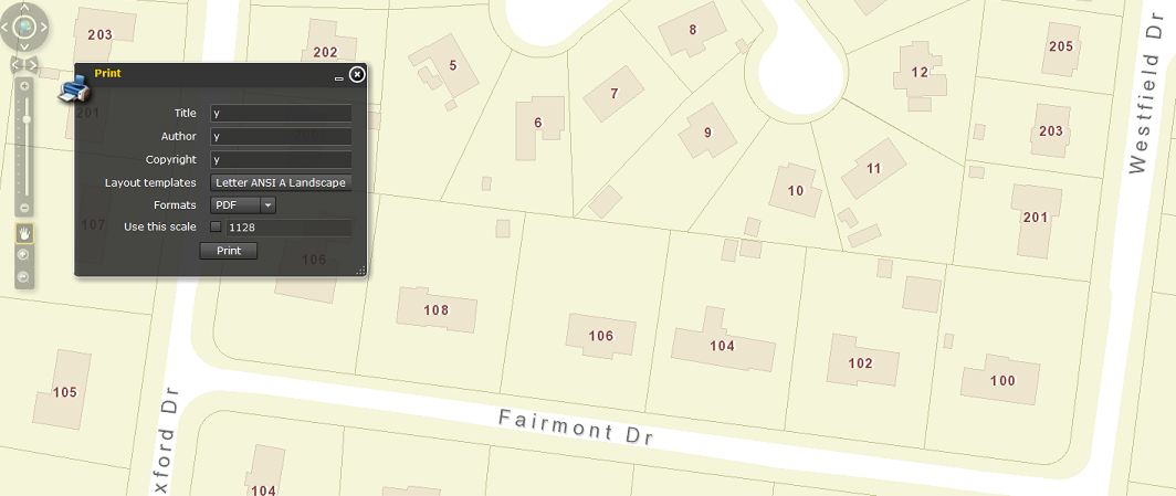
I am having a very similar issue with flexviewer 3.6 and ArcGIS Server 10.2. I recently upgraded a test server to version 10.3 and tested this by pointing the print service to the 10.3 version but I am still getting an issue where the extent at which I print differs from the print page that is created. Typically I am zoomed into a scale of 1128 and click the print button and the page that is created zooms out one scale to 2257 where my addresses labels are turned off.
Here is the initial scale at level 1128 without the option to print at this scale
(InitialScale.png)
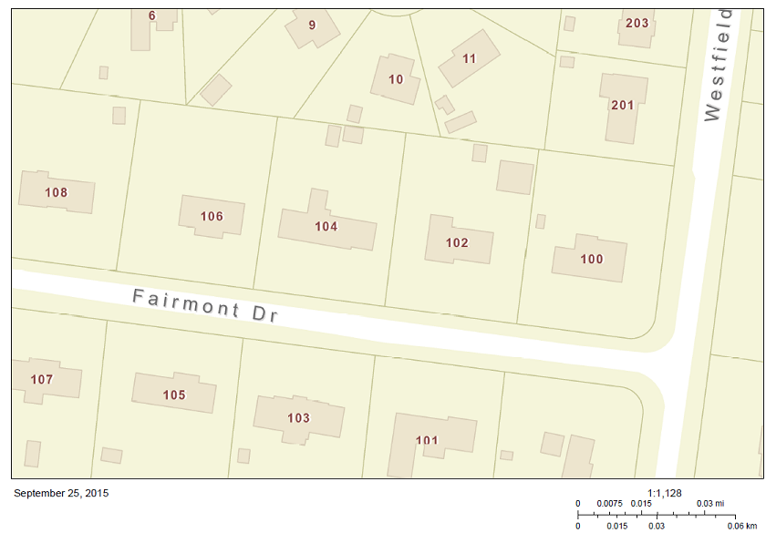
The resulting print page zooms out one level to 2257 which my address label are turned off at
(PrintPage.png)
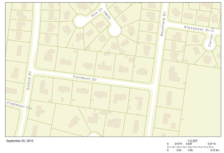
With the option checked to print at set scale and 1128 entered the resulting image appears to be taken at 564 versus 1128
(PrintPageSetScale.png)
I was hoping the jump to 10.3 would rectify this but it appears it does not. Has anyone found a work around or fix for this?
Thank you,
Chris