- Home
- :
- All Communities
- :
- Products
- :
- ArcGIS Enterprise
- :
- ArcGIS Enterprise Questions
- :
- Re: caching symbols at same scale at different siz...
- Subscribe to RSS Feed
- Mark Topic as New
- Mark Topic as Read
- Float this Topic for Current User
- Bookmark
- Subscribe
- Mute
- Printer Friendly Page
caching symbols at same scale at different sizes?
- Mark as New
- Bookmark
- Subscribe
- Mute
- Subscribe to RSS Feed
- Permalink
Hello,
You have defined layer symbologies for one layer or two different..
check symbol size.
- Mark as New
- Bookmark
- Subscribe
- Mute
- Subscribe to RSS Feed
- Permalink
Can you provide some more information? As Avinash suggested - are these symbols in one layer or two? Is there a reference scale set on the data frame? Are the symbol sizes the same in the map document before the cache?
- Mark as New
- Bookmark
- Subscribe
- Mute
- Subscribe to RSS Feed
- Permalink
OK here is some details
The layers is copied 7 times and visibility is set on each layer at different symbol sizes, added as a group layer. Zooms in just fine in the mxd. The layer was created as an empty feature class and points were added to it during an edit session. I tried setting a spatial index, same result.
Scales set on layers:
No reference scale is set on the dataframe
Scales set on cache (latest, I've tired different values = same result):
- Mark as New
- Bookmark
- Subscribe
- Mute
- Subscribe to RSS Feed
- Permalink
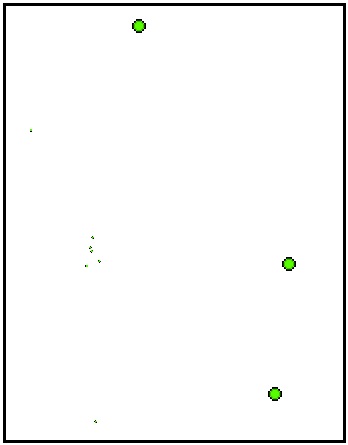
When I tested in a web map the symbols would get big, then small, then big again as I zoom in (maybe this is normal behavior?) and in ArcMap the symbols are different sizes at the same scale. in both cases some of the points on the outside are cut in half, like the extent chopped them off. I set the extent to zoom to layer.
- Mark as New
- Bookmark
- Subscribe
- Mute
- Subscribe to RSS Feed
- Permalink
Since the data is cached, it acts like an image or graphic. Let's say your cache levels are 1:1000, 1:2000, 1:4000 - if you view the cache at 1:2000 the symbols should look fine (as expected). If you were to view the cache at 1:2500 or 1:3000 for example - scales that are not cached - the symbols will distort from the original cache scale.
Saying this, how do your symbols look at one of your exact cache scales? Do they appear as expected?
For the issue regarding the cut-off symbols, are you setting a caching Area of Interest? When you zoomed to the layer before publishing the service, did you also set this extent as the data frame extent in the Data Frame properties?
- Mark as New
- Bookmark
- Subscribe
- Mute
- Subscribe to RSS Feed
- Permalink
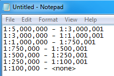
I was looking at the cache scales you set:

If these are the scales you are going with, I would recommend that you set you visible ranges for the layers in ArcMap so that the caching scale is in the middle of the layer visibility range in ArcMap. Example:
1:15,000,000 - 1:6,500,001
1:6.500,000 - 1:2,000,001
1:2,000,000 - 900,001
1:900,000 - 1:650,001
1:650,000 - 1:400,001
1:400,000 - 1:175,001
1:175,000 - none
- Mark as New
- Bookmark
- Subscribe
- Mute
- Subscribe to RSS Feed
- Permalink
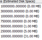
From above statement looks like your cache tiles are not completed yet,
Please check and share complete statues and scale range.