Turn on suggestions
Auto-suggest helps you quickly narrow down your search results by suggesting possible matches as you type.
Cancel
- Home
- :
- All Communities
- :
- Products
- :
- ArcGIS Enterprise
- :
- ArcGIS Enterprise Portal Questions
- :
- green mystery lines in layout view
Options
- Subscribe to RSS Feed
- Mark Topic as New
- Mark Topic as Read
- Float this Topic for Current User
- Bookmark
- Subscribe
- Mute
- Printer Friendly Page
green mystery lines in layout view
Subscribe
21106
24
08-22-2012 08:59 AM
08-22-2012
08:59 AM
- Mark as New
- Bookmark
- Subscribe
- Mute
- Subscribe to RSS Feed
- Permalink
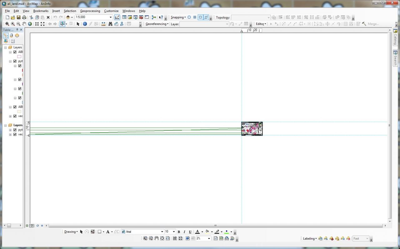
What the heck are these?
This map was fine the last time I opened it, but now there are these green lines. I've run a basic python script to update layer symbology in between opening the map before and opening it now, but these lines haven't appeared in any of the other maps I ran the same script on.
The green mystery lines only appear in the layout view and they seem to go on forever. They don't seem to be associated with any of the layers in my map (I tried turning them off one at a time in the TOC). I can't select them or identify them. Closing and reopening the mxd doesn't help.
thanks,
Angela
24 Replies
08-19-2013
02:09 PM
- Mark as New
- Bookmark
- Subscribe
- Mute
- Subscribe to RSS Feed
- Permalink
I've also experienced the same problem, but also in plotting. In a normal ANSI-D plot, everything seemed to be fine except for USGS quads, there would be two lines that might start at the NW corner at maybe 30 degree angles, and of course get wider the further away they moved from the origin. When going to a tiled plot (larger than ANSI D with multiple pages), random lines would often appear at the point of origin on different feature classes and go all over the map. NONE of these could be seen on the preview so I never knew if or why they would appear.
12-04-2013
02:22 PM
- Mark as New
- Bookmark
- Subscribe
- Mute
- Subscribe to RSS Feed
- Permalink
This issue just happened on my co-worker's workstation (ArcGIS 10 on Windows 7 Pro)...
I've never seen this happen before but it is definitely not related to any layer geometry issues nor page layout guides... Those are completely different issues and have no value to this thread. I see no real resolution provided in this forum except copying the project into a new .mxd file (not really a "solution")...
I believe somehow a phython logic error is occurring within ArcMap's layout rendering commands. In my coworker's project, the green lines appear after using the select element arrow to adjust the size and position of the data frame. I can make the lines disappear temporarily by simply opening the layout properties dialogue and immediately clicking "okay" (which closes the dialogue and I believe resets the entire Layout View rendering script that is part of ESRI's base ArcGIS code). I then hit the refresh view button and the lines are gone. I can then make the lines reappear by adjusting the size and position of the data frame again using the select element arrow... Nothing else I do seems to remove the lines besides opening the layout properties dialogue (which again I think completely reloads ESRI layout rendering script).
One interesting note - my coworker has "rotated" the data frame view under the layout properties dialogue for this project. I'm not sure if that is a variable involved in the issue or not. I think Duncan is on to the issue in dealing with his python script generating the green lines. I hope ESRI will look into this issue more and resolve it via an update as I believe it is a software bug.
hms4th
03-31-2014
05:37 AM
- Mark as New
- Bookmark
- Subscribe
- Mute
- Subscribe to RSS Feed
- Permalink
If this issue hasn't been solved, here's how I fixed mine when I encountered this same problem. Draw a rectangle on the line(s), like if you're selecting elements. You won't see any visible indication that it's selected but that�??s okay. Mouse right click on the white portion of the screen and choose Delete.
10-02-2014
12:59 PM
- Mark as New
- Bookmark
- Subscribe
- Mute
- Subscribe to RSS Feed
- Permalink
thanks Beverly - fixed it!!
09-04-2015
06:18 AM
- Mark as New
- Bookmark
- Subscribe
- Mute
- Subscribe to RSS Feed
- Permalink
This worked! Thanks
01-27-2016
02:30 PM
- Mark as New
- Bookmark
- Subscribe
- Mute
- Subscribe to RSS Feed
- Permalink
This worked perfectly, thanks!
04-27-2016
06:49 AM
- Mark as New
- Bookmark
- Subscribe
- Mute
- Subscribe to RSS Feed
- Permalink
Thank you Beverly. This solved my problem. I would still love to know WHAT causes this so that it may be avoided in the future. Thanks again,
Stacy
10-12-2016
06:01 AM
- Mark as New
- Bookmark
- Subscribe
- Mute
- Subscribe to RSS Feed
- Permalink
worked for me!! thanks Bev!!
05-01-2019
04:20 AM
- Mark as New
- Bookmark
- Subscribe
- Mute
- Subscribe to RSS Feed
- Permalink
Yes!! Thank you. This worked for me as well.
04-04-2014
02:02 AM
- Mark as New
- Bookmark
- Subscribe
- Mute
- Subscribe to RSS Feed
- Permalink
If this issue hasn't been solved, here's how I fixed mine when I encountered this same problem. Draw a rectangle on the line(s), like if you're selecting elements. You won't see any visible indication that it's selected but that�??s okay. Mouse right click on the white portion of the screen and choose Delete.
I hade the exact same issue, and pinay1975's solution solved it perfectly. Thank you!