- Home
- :
- All Communities
- :
- Products
- :
- ArcGIS Earth
- :
- ArcGIS Earth Questions
- :
- Re: Basemaps unavailable at 1.8
- Subscribe to RSS Feed
- Mark Topic as New
- Mark Topic as Read
- Float this Topic for Current User
- Bookmark
- Subscribe
- Mute
- Printer Friendly Page
Basemaps unavailable at 1.8
- Mark as New
- Bookmark
- Subscribe
- Mute
- Subscribe to RSS Feed
- Permalink
Similarly to an issue I see below, we don't have basemaps available. Some of this will be known, but is documented for completeness
- In both ArcGIS Earths (1.6.1 and 1.8) services from https://services.arcgisonline.co.nz cannot be loaded, probably because of proxy issues.
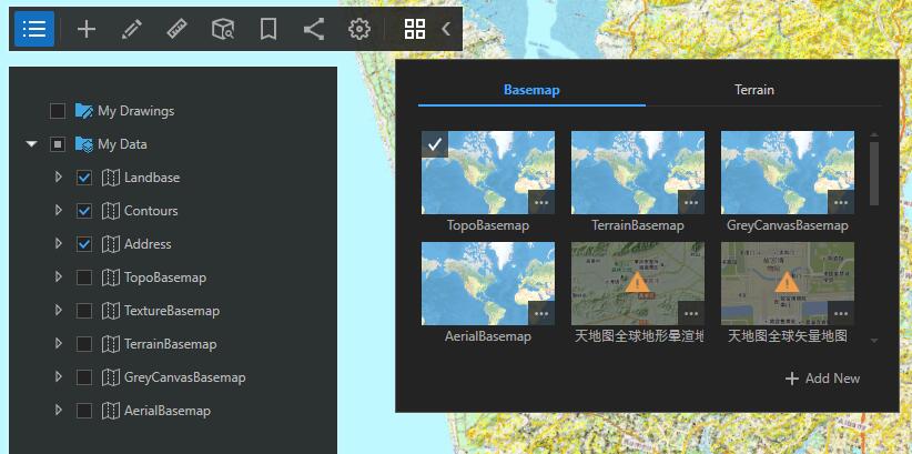
- In ArcGIS Earth 1.6.1 these basemaps are simply not shown
- In ArcGIS Earth 1.8 these basemaps are shown with an exclamation
- In ArcGIS Earth 1.6.1 Basemaps from Auckland Council (https://mapspublic.aklc.govt.nz/) are shown and work
- In ArcGIS Earth 1.8 Basemaps from Auckland Council (https://mapspublic.aklc.govt.nz/) are shown but with an exclamation and do not work.
- In this case, 1.8 does not seem to like mixing it’s WGS84 Web Mercator projection with the AKLC NZTM based tile services.
Has1.8 introduced this restriction?
Re the ‘Proxy’ issue for external services from https://services.arcgisonline.....
If I add proxy info to ArcGIS Earth 1.8 I can add the external basemap, but can’t connect to Enterprise on premises Portal (version 10.6.1)
If I remove proxy info to ArcGIS Earth 1.8 I can’t add the external basemap, but can connect to Enterprise on premises Portal (version 10.6.1)
Which leaves us between a rock and a hard place.
We currently have no basemaps available for users
Any help would be greatly appreciated
Thanks
- Mark as New
- Bookmark
- Subscribe
- Mute
- Subscribe to RSS Feed
- Permalink
Hi Anna,
Thanks for your feedback.
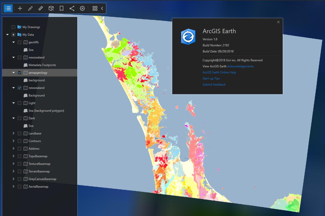
I have tried the services from https://mapspublictest.aklc.govt.nz/arcgis/rest/services/Basemap in ArcGIS Earth 1.8, they can be added and show successfully as basemap or TOC layers. No matter the spatial reference of ArcGIS Earth is Web Mercator or WGS84, there is no exclamation for the basemap.
For the services from https://services.arcgisonline.co.nz/arcgis/rest/services, they also work well at my side.
Because the spatial reference of the tile services is 2193 which is not Web Mercator(102100 or 3857) or WGS84(4326), ArcGIS Earth display the layers as dynamic layers, rather than according to the tile info. It could be a bit slow to show the layers.
For the proxy issue, it might be caused by your proxy rules? Please try to connect to the internal and external services from IE to check if it works. ArcGIS Earth uses the default Internet Settings (IE) proxy, so if it works fine from Internet Explorer on the server, it should be OK from ArcGIS Earth as well.
Thanks,
Xuewen
- Mark as New
- Bookmark
- Subscribe
- Mute
- Subscribe to RSS Feed
- Permalink
Hi,
Thanks for your response, however the test you did didn't quite fit our scenario, in fact you proved you have the same issue in your first screenshot where you have warning symbols over your local basemaps
- You added the URLs manually to the basemap widget which works, and we can confirm that
- We need to 'fix' where those same tiled basemaps are automatically made available to ArcGIS Earth via the basemap switcher from the basemap group in the active portal. Not manually added.
- It seems that in this scenario, the ability to switch to dynamic images isn't available as it is when adding the URLs in manually.
- The proxy is not an issue
The workaround for us is to let all users know how to manually add the basemaps, but that is not an elegant solution.
Many thanks
Anna
- Mark as New
- Bookmark
- Subscribe
- Mute
- Subscribe to RSS Feed
- Permalink
Hi Anna,
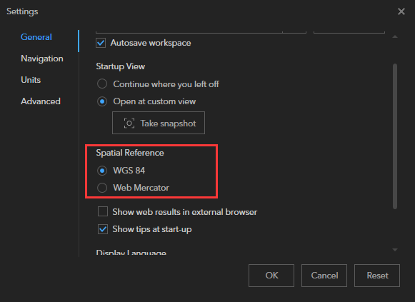
Thanks for bringing it up. Indeed, the startup experience is different from adding layers manually. At startup, if you have mixed spatial reference basemaps (WGS84, Web Mercator) in the active portal's basemap group, only basemaps whose spatial reference are the same as current application spatial reference setting are well displayed, and others are marked with warning symbol. The mechanism is adopted for multiple reasons but is also for improving the startup performance. Current workaround is to either adding other basemaps manually, or startup Earth with either of the spatial reference settings.
- Mark as New
- Bookmark
- Subscribe
- Mute
- Subscribe to RSS Feed
- Permalink
Hi Anna,
Thanks for your detailed information. I misunderstood your question before.
We will try to remove the warning symbols for basemaps though the spatial reference does not match the spatial reference setting of ArcGIS Earth. The change will be applied in V1.9.
Thanks,
Xuewen
- Mark as New
- Bookmark
- Subscribe
- Mute
- Subscribe to RSS Feed
- Permalink
Hi Anna,
ArcGIS Earth V1.9 is live and includes some enhancements for basemaps and tile layers. Could you help to check if your issue can be addressed in V1.9? Thanks.
You can get ArcGIS Earth V1.9 from ArcGIS Earth | ArcGIS
Thanks,
Xuewen