- Home
- :
- All Communities
- :
- Products
- :
- ArcGIS Reality
- :
- ArcGIS Drone2Map
- :
- ArcGIS Drone2Map Questions
- :
- Failed to export Image Collection
- Subscribe to RSS Feed
- Mark Topic as New
- Mark Topic as Read
- Float this Topic for Current User
- Bookmark
- Subscribe
- Mute
- Printer Friendly Page
Failed to export Image Collection
- Mark as New
- Bookmark
- Subscribe
- Mute
- Subscribe to RSS Feed
- Permalink
Drone2Map version 2025.2.0
Project has 251 images over lake surface + shoreline.
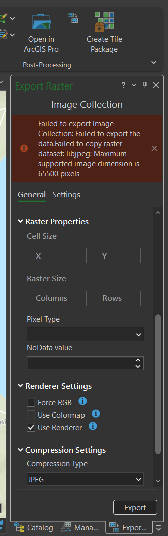
I am attempting to export a basic orthomosaic through the image collection export. Originally, I tried to export as a TIF but that failed, so I changed the output format to JPG and lowered the compression quality to see if that would work. Each time I received the following error:
"Failure to export Image Collection: Failed to export the data. Failed to copy raster dataset: libjpeg: Maximum supported image dimension is 65500 pixels"
I produced a true ortho of the data set first, but due to issues with the flight that day + glare on the water surface a majority of the images were not included in the final map. This was the first flight on that lake so this is mostly needed to see how we can improve subsequent surveys conducted there in the future.
- Mark as New
- Bookmark
- Subscribe
- Mute
- Subscribe to RSS Feed
- Permalink
Hi @TaraBeckman,
Would you mind sharing the exact settings you were using within the Export Raster pane before the error occurs? Feel free to include a screenshot.
I have a few other questions for you as well:
- Are the TIFF and JPEG formats the only ones not allowing a proper export? (i.e. have you tried PNG, GIF, etc.)
- Is this occurring on other projects as well?
- Is there a reason you haven't applied the patch yet for 2025.2.1?
Thank you,
Mark