- Home
- :
- All Communities
- :
- Products
- :
- ArcGIS Drone2Map
- :
- ArcGIS Drone2Map Questions
- :
- 'Create Orthomosaic' is checked in Processing Opti...
- Subscribe to RSS Feed
- Mark Topic as New
- Mark Topic as Read
- Float this Topic for Current User
- Bookmark
- Subscribe
- Mute
- Printer Friendly Page
'Create Orthomosaic' is checked in Processing Options, but none is actually created
- Mark as New
- Bookmark
- Subscribe
- Mute
- Subscribe to RSS Feed
- Permalink
- Report Inappropriate Content
Hey everyone,
I'm using a d2m trial, and am having trouble getting it to create my orthomosaic. 'Create Orthomosaic' and 'Merge Tiles' are checked in processing options, I can watch it being processed in the Processing Log without any errors, but no ortho is actually added to the project, nor is it anywhere to be found in my project folder.
The processing report shows a preview of everything as it should look, including the ortho, but only the DSM and DTM are actually created and added to the project.
In case any of this helps:
- I'm running on Drone2Map 1.3.1.226
- The project is 133 images (1.11gb)
- Images were taken by a Mavic Air, and the flight plan was drawn up using Pix4D Capture
- Average GSD is 2.04 cm
Has anyone else run into this issue / know how to fix it?
Thanks!
Solved! Go to Solution.
- Mark as New
- Bookmark
- Subscribe
- Mute
- Subscribe to RSS Feed
- Permalink
- Report Inappropriate Content
Hey Angela,
I was not able to resolve the issue in Drone2Map. I was able to find a workaround by using ArcGIS Pro. If you have the image analyst extension in ArcGIS Pro then you can use it to create an imagery workspace that allows you to go step by step through creating the Orthomosaic. Hope that helps.
- Mark as New
- Bookmark
- Subscribe
- Mute
- Subscribe to RSS Feed
- Permalink
- Report Inappropriate Content
Hi everyone
First, I apologize for the slow response on this. The good news is we have found the problem, and we have a fix for you.
We have found a bug that relates to newer cameras and an outdated copy of the camera database. This has been fixed with Drone2Map version 1.3.2 which will be available on or before November 14. We'll have a blog here (and your software will notify you) when the new version is available.
If any of you are working on urgent projects and cannot wait until next week, we can give you a workaround that involves manually replacing system files. Since that is a bit risky, we’d recommend you wait for the new version, but if anyone on this thread needs the workaround urgently, email us at drone2map@esri.com and we'll send you the steps to fix this problem.
Thanks for your patience.
Cody Benkelman
- Mark as New
- Bookmark
- Subscribe
- Mute
- Subscribe to RSS Feed
- Permalink
- Report Inappropriate Content
I have experienced this same problem this week with some drone imagery. I am using Drone2Map version 1.3.2.232.
After 2 days of processing, I have a folder full of ortho tiles that I can individually add, but no full orthomosaic. The processing report shows an image of an orthomosaic and I don't see any major issues with the image in the pdf...
Is there a chance that the orthomosaic was going to be too large? I feel like I've done a similarly sized area before, but I'll try a portion of this project and see how the process works.
- Mark as New
- Bookmark
- Subscribe
- Mute
- Subscribe to RSS Feed
- Permalink
- Report Inappropriate Content
April
As noted above, we had a known bug that could cause this, but we believed it had been fixed in 1.3.2. If you're getting tiles in the orthomosaic_tiles folder, this sounds like a different problem.
How big is your project in terms of # of images? If it's more than ~1500-2000 photos, you may be having memory problems, so may need to split it into two subprojects - ensure some images overlap (~2 flightlines) and include ground control in the overlap region.
Did the processing complete normally and declare "success"? If you have ArcGIS Pro (or ArcMap), you should be able to load the tiles into a mosaic dataset and review them - are there tiles missing?
Best would be if you can send us the log file - Go to Processing Options/Resources and find the link to the log.
Cody B
- Mark as New
- Bookmark
- Subscribe
- Mute
- Subscribe to RSS Feed
- Permalink
- Report Inappropriate Content
Cody, thanks for looking into my issue! 
I've attached the logs. There are 747 images in this project. The project took 2 days to compile everything and stitch things together. The drone that was used to fly is a DJI Inspire 2. The computer doing the work is dedicated to Drone2Map and is a Dell Optiplex 7040, i7-6700 CPU @3.40GHz with 16GB of RAM running Windows 7.
I've started a new project using only the first 399 images. It is currently at 56%.
- Mark as New
- Bookmark
- Subscribe
- Mute
- Subscribe to RSS Feed
- Permalink
- Report Inappropriate Content
April
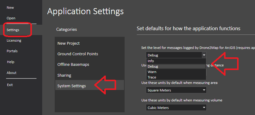
it appears you do not have your logging set to "debug" - we can't see anything useful in these log files but if you could enable debug mode and try again, let us know the results.
If this continues, it's probably best for you to log a support incident at http://support.esri.com/
Cody B
- Mark as New
- Bookmark
- Subscribe
- Mute
- Subscribe to RSS Feed
- Permalink
- Report Inappropriate Content
Hey April,
The Drone2Map update 1.3.2 fixed my issue completely and I am able to create Orthomosaics using images from a DJI Mavic Air without any issue. As Cody has noted above this does sound like a different issue. Hopefully separating the images into two sub projects proves successful.
Cheers,
Bryan
- « Previous
-
- 1
- 2
- Next »
- « Previous
-
- 1
- 2
- Next »