Turn on suggestions
Auto-suggest helps you quickly narrow down your search results by suggesting possible matches as you type.
Cancel
- Home
- :
- All Communities
- :
- Products
- :
- ArcGIS Dashboards
- :
- ArcGIS Dashboards Questions
- :
- Polygon centroid rendering in Ops Dashboard
Options
- Subscribe to RSS Feed
- Mark Topic as New
- Mark Topic as Read
- Float this Topic for Current User
- Bookmark
- Subscribe
- Mute
- Printer Friendly Page
Polygon centroid rendering in Ops Dashboard
Subscribe
3998
1
03-17-2015 04:49 AM
03-17-2015
04:49 AM
- Mark as New
- Bookmark
- Subscribe
- Mute
- Subscribe to RSS Feed
- Permalink
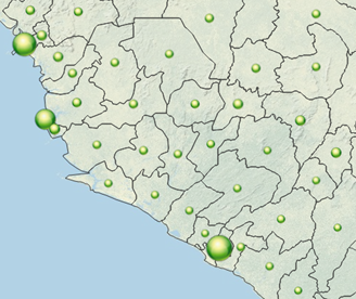
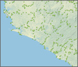
My polygon layer in a web map is using the "Counts and Amounts" symbology, and it appears as expected in the web map, with points at the polygon centroids, and the point sizes dependent on an attribute value. However, when the same web maps is viewed in Ops Dashboard, it looks like it's trying to draw all polygon vertexes with my point symbol, instead of using the centroid. Has anyone else experienced or solved this? Thanks!


1 Reply
03-24-2015
02:53 PM
- Mark as New
- Bookmark
- Subscribe
- Mute
- Subscribe to RSS Feed
- Permalink
Hi Jeff,
This is a known bug / limitation at this time. Once we have a fix in place, I'll post it on this thread.
Thanks,
Chris