Turn on suggestions
Auto-suggest helps you quickly narrow down your search results by suggesting possible matches as you type.
Cancel
- Home
- :
- All Communities
- :
- Products
- :
- ArcGIS Dashboards
- :
- ArcGIS Dashboards Questions
- :
- Re: Basemap through a looking-glass?
Options
- Subscribe to RSS Feed
- Mark Topic as New
- Mark Topic as Read
- Float this Topic for Current User
- Bookmark
- Subscribe
- Mute
- Printer Friendly Page
Basemap through a looking-glass?
Subscribe
5102
4
02-26-2013 02:56 AM
02-26-2013
02:56 AM
- Mark as New
- Bookmark
- Subscribe
- Mute
- Subscribe to RSS Feed
- Permalink
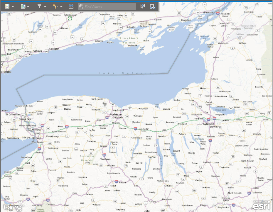
I have to say, I must have something gravely wrong with my settings because I am SURE that someone else would have brought up this problem as soon as the Operations Dashboard was launched. So, I am going to ask, and probably need a slap to the back of the head when I get the answer....
Why are the basemaps illegible through the Operations Dashboard? It seems like the zoom levels do not match the cached basemaps extent. It is almost like looking the wrong way through a pair of weak binoculars. When you zoom, everything is like expected until you get your new tiles. Many times, it makes a standard "streets" type basemap useless because you cannot read the road names, etc...
Picture below...
Thanks,
--Adam
[ATTACH=CONFIG]22168[/ATTACH]
4 Replies
02-27-2013
05:27 AM
- Mark as New
- Bookmark
- Subscribe
- Mute
- Subscribe to RSS Feed
- Permalink
Adam-
Thanks for reporting this. We'll take a look.
-Doug
Thanks for reporting this. We'll take a look.
-Doug
07-11-2013
07:54 AM
- Mark as New
- Bookmark
- Subscribe
- Mute
- Subscribe to RSS Feed
- Permalink
Adam-
Thanks for reporting this. We'll take a look.
-Doug
The problem is still with us in the multi-display device setup. Basemap labeling is almost completely useless in all readily available basemaps in the Operations Dashboard. The only way to read most labeling is to zoom in and read before the screen is refreshed.
Any answers?
Thanks,
--Adam
EDIT -- After some more investigation and an inadvertent change made before a save in ArcGIS Online, I discovered that we are working on a complex relationship of map extent, zoom level and size of viewing area - proportionally to the map widget that I am viewing the saved map from in Operations Dashboard.
To recreate, construct a map in ArcGIS Online. Make the browser window the same size as your screen. (mine is 1920x1080) Open the "Details" button to make the contents side-pane display. Set the extent of your basemap and then save. Make a new multi-display operational view with that saved map. Note the labeling and readability. Save and then close the Operations View.
Next, go back to ArcGIS Online, collapse the side-pane and re-center the map. Do not change zoom level! Save. Re-open the Operations view that was created above. Note the labeling and readability.
I would have made screenshots, but I don't have enough time at the moment.
-_Adam
07-11-2013
09:57 AM
- Mark as New
- Bookmark
- Subscribe
- Mute
- Subscribe to RSS Feed
- Permalink
One more note for my discovery above:
If you DO NOT save bookmarks with the exact same browser window size and side-pane closed, when a bookmark is used in OD multi-display view - the extent/zoom ratio will now be changed.
I am sorry if this is not easy to follow. It is hard to describe.
I believe that the problem lies in the fact that the cached basemap is stored in a raster format (jpg, etc.) and the OD in multi-display mode is out of sync with each zoom level in the cached service at the raster's native resolution. That is, unless you find the sweet-spot when you create your ArcGIS Online map.
Like looking at all of your 18 megapixel home pictures, but in a window that is 200x300 pixels.
--Adam
08-07-2013
11:41 AM
- Mark as New
- Bookmark
- Subscribe
- Mute
- Subscribe to RSS Feed
- Permalink
We have the same issue