- Home
- :
- All Communities
- :
- Products
- :
- ArcGIS Collector
- :
- ArcGIS Collector Questions
- :
- Re: Location Profile problems
- Subscribe to RSS Feed
- Mark Topic as New
- Mark Topic as Read
- Float this Topic for Current User
- Bookmark
- Subscribe
- Mute
- Printer Friendly Page
Location Profile problems
- Mark as New
- Bookmark
- Subscribe
- Mute
- Subscribe to RSS Feed
- Permalink
I recently changed the basemap on most of my maps to use my own imagery. This basemap uses NAD83 Kentucky State Plane South. My GNSS receiver uses NAD 1983 2011.
I put that information into my new location profile, says there is no need for transformation. Great.
But then when I go to open my map, it says the location profile does not match the coordinate system of the map. Why would this be? I thought all maps in AGOL took on the coordinate system of the basemap.
It I choose the Default location profile, my maps open no problem, but that assumes my GNSS coordinate system is WGS 1984, which it isn't (or shouldn't be...).
Anyone have any insight into what to do here?
- Mark as New
- Bookmark
- Subscribe
- Mute
- Subscribe to RSS Feed
- Permalink
A few questions:
The feature service that you are collecting data points from your GPS using Collector, what coordinate system was it published using?
Did you publish this "basemap" to AGOL or is this on your local system? Again, if published, to what coordinate system?
How far off is the GPS data in relation to your basemap?
NAD83 Kentucky State Plane South is not necessarily NAD 1983 2011. If you can load these features in to an ArcMap or Pro session and take a look at the coordinate systems list for each, it may become apparent where the difference is occurring.
- Mark as New
- Bookmark
- Subscribe
- Mute
- Subscribe to RSS Feed
- Permalink
The feature service and base map are both in NAD 83 Kentucky State Plane South. The basemap is an AGOL hosted tile layer. They are both using the same coordinate system when I check them in ArcMap and when I peek into each of their services directory pages on AGOL.
When I am using the Default location provider and the accuracy of my GNSS receiver is its best (7cm), it seems off by about ~2ft on the map from where the receiver actually is.
I use an NTRIP correction service through the KY CORS network for my receiver.
- Mark as New
- Bookmark
- Subscribe
- Mute
- Subscribe to RSS Feed
- Permalink
That sounds like a coordinate transformation issue between NAD83 and NAD83(2011). They are slightly different.
Please confirm your data is not:
Basemap is NAD83 (US Feet) - State Plane Kentucky South (WKID:2246)
GPS Data is NAD83 (2011) (US Feet) - State Plane Kentucky South (WKID:6475)
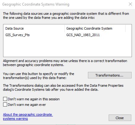
If you load both of these into a blank ArcGIS session do you get a Geographic Coordinate Systems Warning, similar to below?