Turn on suggestions
Auto-suggest helps you quickly narrow down your search results by suggesting possible matches as you type.
Cancel
- Home
- :
- All Communities
- :
- Products
- :
- ArcGIS Collector
- :
- ArcGIS Collector Questions
- :
- Exporting Features in a FGDB with Attachments
Options
- Subscribe to RSS Feed
- Mark Topic as New
- Mark Topic as Read
- Float this Topic for Current User
- Bookmark
- Subscribe
- Mute
- Printer Friendly Page
Exporting Features in a FGDB with Attachments
Subscribe
916
1
06-26-2020 08:45 AM
06-26-2020
08:45 AM
- Mark as New
- Bookmark
- Subscribe
- Mute
- Subscribe to RSS Feed
- Permalink
Background:
I collect field data with Collector in IOS and Sync it with my Portal. In Portal I export it to a FGDB and download the zip file into a folder and unzip it.
In order to get it in a coordinate system that is usable for me and get the x, y, and z values I tried to set up a model. Everything works great but the photo Attachments don't come with.
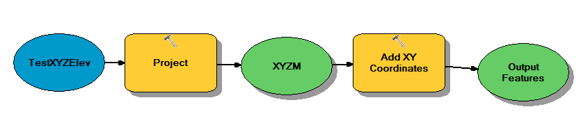
Does anyone know how to export attachments in a FGDB to another one or maybe there is another way of doing this?
1 Reply
07-01-2020
09:48 AM
- Mark as New
- Bookmark
- Subscribe
- Mute
- Subscribe to RSS Feed
- Permalink
Paul Wirth might want to check the state of this environment setting. Maintain Attachments (Environment setting)—Geoprocessing | Documentation