- Home
- :
- All Communities
- :
- Products
- :
- ArcGIS CityEngine
- :
- ArcGIS CityEngine Questions
- :
- Why do my static models become squashed when align...
- Subscribe to RSS Feed
- Mark Topic as New
- Mark Topic as Read
- Float this Topic for Current User
- Bookmark
- Subscribe
- Mute
- Printer Friendly Page
Why do my static models become squashed when aligning shapes to terrain?
- Mark as New
- Bookmark
- Subscribe
- Mute
- Subscribe to RSS Feed
- Permalink
Hi everyone,
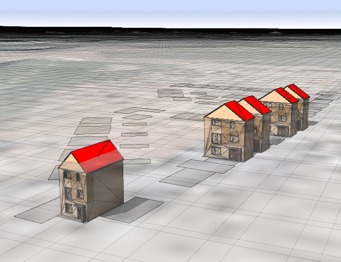
I have a scenario where I am importing a set of building footprints from a fGDB and adding static models on to each. When I'm working at y=0, everything is fine (apart from the house models obviously being below the terrain). This can be seen in the image on the left.
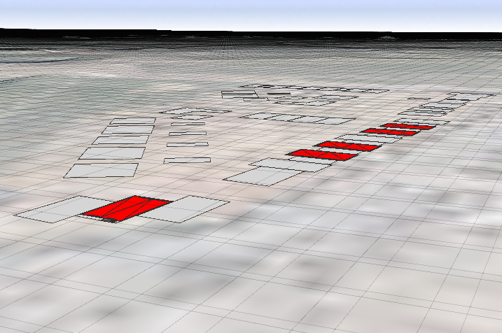
However, when I select the footprints and align them to the terrain, the house models become squashed. Why is this? I'm not doing anything clever here - I'm simply importing a model based on the start rule of the building footprint (no scaling commands involved), so I'm sure I'm missing something obvious! It doesn't matter whether I align the shapes to the terrain before or after generating the models, the results are the same.
Can anyone shed any light on this please??
Many thanks in advance,
Jack
Solved! Go to Solution.
Accepted Solutions
- Mark as New
- Bookmark
- Subscribe
- Mute
- Subscribe to RSS Feed
- Permalink
Hi Jack, I'm guessing that you may have converted your models into shapes.
Try this:
1. Click on Shapes > Align Shapes to Terrain...
2. Under Align function > Select Translate to Maximum
If that works, then you can use any of the Translate-based align functions (not the Project-based align functions) to align your objects to terrain.
- Mark as New
- Bookmark
- Subscribe
- Mute
- Subscribe to RSS Feed
- Permalink
Hello! Just bumping this one - did anyone have any thoughts? I haven't been able to solve it and it's really puzzling me...!
- Mark as New
- Bookmark
- Subscribe
- Mute
- Subscribe to RSS Feed
- Permalink
Hi Jack, I'm guessing that you may have converted your models into shapes.
Try this:
1. Click on Shapes > Align Shapes to Terrain...
2. Under Align function > Select Translate to Maximum
If that works, then you can use any of the Translate-based align functions (not the Project-based align functions) to align your objects to terrain.
- Mark as New
- Bookmark
- Subscribe
- Mute
- Subscribe to RSS Feed
- Permalink
Thanks David - that's what I was after!