- Home
- :
- All Communities
- :
- Products
- :
- ArcGIS CityEngine
- :
- ArcGIS CityEngine Questions
- :
- Extrusion based on highest vertex after alignment ...
- Subscribe to RSS Feed
- Mark Topic as New
- Mark Topic as Read
- Float this Topic for Current User
- Bookmark
- Subscribe
- Mute
- Printer Friendly Page
Extrusion based on highest vertex after alignment to terrain
- Mark as New
- Bookmark
- Subscribe
- Mute
- Subscribe to RSS Feed
- Permalink
Maybe this question was asked before but I could not find anything about it and it affects all my projects 😕
So basically I want CGA to measure my extrusion distance from the HIGHEST vertex of each shape instead of the lowest which is the rule default of extrude(world.up.flatTop). Because when the my buildings are aligned to terrain and extruded based on lowest vertex my building look shorter than they are supposed to in terms of height.
Picture attached
Solved! Go to Solution.
Accepted Solutions
- Mark as New
- Bookmark
- Subscribe
- Mute
- Subscribe to RSS Feed
- Permalink
You are applying the split along the y extent which starts at the lowest y coordinate. The orange ground floor has a height of 3, but because the initial shape is non-planar the height is lower at some vertices.
Here is a modification to you rule.
Lot-->
alignScopeToAxes(y)
Extrude(scope.sy)
Extrude(nonPlanarHeight) -->
extrude(world.up.flatTop, height + nonPlanarHeight)
Building(nonPlanarHeight)
Building(nonPlanarHeight) -->
split(y) { nonPlanarHeight : Basement | { ~floorheight : Floor. }* }
Basement --> color("#fc824e")- Mark as New
- Bookmark
- Subscribe
- Mute
- Subscribe to RSS Feed
- Permalink
Hi Jafar!
You could add the current geometry height to the extrusion height.
For example
Lot --> extrude(world.up.flatTop, myHeight + geometry.height)or
Lot --> alignScopeToAxes(y)
extrude(world.up.flatTop, myHeight + scope.sy)
Hope that helps!
- Mark as New
- Bookmark
- Subscribe
- Mute
- Subscribe to RSS Feed
- Permalink
Thanks for your answer Martin,
but this CGA adds an extra basement to my highest vertex where the extrusion is supposed to be based on. See attachment please. In this case there is a 4 floored building with floorheight of 3 meters. And I want to be extruded to 4*3=12 meters from the highest vertex of the lot.
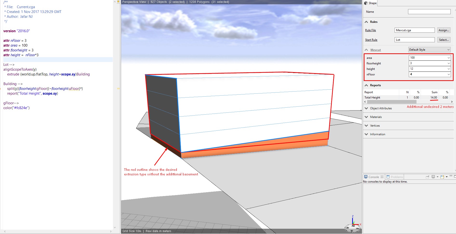 I want the total height to be not more than 12.50 meters
- Mark as New
- Bookmark
- Subscribe
- Mute
- Subscribe to RSS Feed
- Permalink
You are applying the split along the y extent which starts at the lowest y coordinate. The orange ground floor has a height of 3, but because the initial shape is non-planar the height is lower at some vertices.
Here is a modification to you rule.
Lot-->
alignScopeToAxes(y)
Extrude(scope.sy)
Extrude(nonPlanarHeight) -->
extrude(world.up.flatTop, height + nonPlanarHeight)
Building(nonPlanarHeight)
Building(nonPlanarHeight) -->
split(y) { nonPlanarHeight : Basement | { ~floorheight : Floor. }* }
Basement --> color("#fc824e")- Mark as New
- Bookmark
- Subscribe
- Mute
- Subscribe to RSS Feed
- Permalink
thank you. it worked. but I still don't get why there's not a simple option/command to choose whether you want the extrusion to be measured from the lowest or highest vertex of a nonplanar shape.
- Mark as New
- Bookmark
- Subscribe
- Mute
- Subscribe to RSS Feed
- Permalink
Happy it worked for you.
We're trying to limit the available parameters and the amount of operations if a goal can also be achieved by a combination of several simpler operations & functions.
- Mark as New
- Bookmark
- Subscribe
- Mute
- Subscribe to RSS Feed
- Permalink
one more question, is nonPlanarHeight a pre-defined function (couldn't find anything about it in CE Help) in here or it is just a symbolic word you put for sync purposes? I am trying to understand the code so I can further develop it myself. thanks in advance for your time
- Mark as New
- Bookmark
- Subscribe
- Mute
- Subscribe to RSS Feed
- Permalink
Its a parameterized rule.
See Online Manual.
So "nonPlanarHeight" in rule definition
Extrude(nonPlanarHeight) -->is just a self-chosen parameter name. Relevant is only that it is called with scope.y
Extrude(scope.sy)Because in this use case scope.y equals the height of a non-planar shape, it makes sense to give the parameter this name.
- Mark as New
- Bookmark
- Subscribe
- Mute
- Subscribe to RSS Feed
- Permalink
Can you also give me directions on how to start the extrusion from the middle vertice of parcel's street edge?
I know I already asked too many questions but I really appreciate your help:)